Supercharge Your Innovation With Domain-Expert AI Agents!

Self-adaptive GPS fusion positioning system and method and medium

A fusion positioning and self-adaptive technology, applied in satellite radio beacon positioning systems, radio wave measurement systems, instruments, etc., can solve the problems of different data accuracy and incorrect matching, and achieve the effect of accurate pose estimation

Pending Publication Date: 2022-06-24
SOUTH CHINA UNIV OF TECH
View PDF0 Cites 2 Cited by
  • Summary
  • Abstract
  • Description
  • Claims
  • Application Information

AI Technical Summary

Problems solved by technology

[0004] The present invention overcomes two existing problems in the prior art, one is the influence of the different accuracy of GPS data obtained in different environments on the accuracy of the entire multi-sensor information fusion system, and the other is the problem of wrong matching of specific areas in the visual pose estimation algorithm , provides a robust and adaptive GPS data fusion method, which can not only remove the mismatch of the sky region in the visual pose estimation, but also enable the mobile robot to obtain a better position when it is in the urban canyon state. pose estimation

Method used


Image

  • Self-adaptive GPS fusion positioning system and method and medium
  • Self-adaptive GPS fusion positioning system and method and medium
  • Self-adaptive GPS fusion positioning system and method and medium

Examples


Embodiment 1

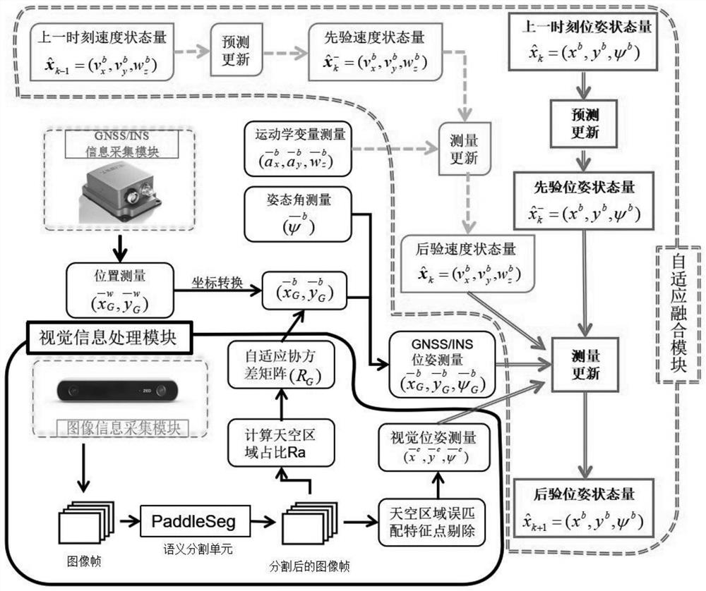
[0051] like figure 1 As shown, an adaptive GPS fusion positioning method, the hardware system includes three modules, namely a GNSS / INS information acquisition module, a visual information processing module and an adaptive fusion module, all the above modules are located on the same carrier, and the adaptive The fusion module fuses the data of the above two modules through a filtering algorithm, and calculates the optimal pose result of the carrier.

[0052] The GNSS / INS information collection module, in this embodiment, uses the xsense MTi-700 GPS / INS module for data collection.

[0053] Further, it includes a global satellite navigation system and an inertial navigation system, wherein the global satellite navigation system acquires and tracks satellites through a GNSS receiver to obtain a navigation solution, that is, the longitude and latitude data where the receiver is located, and the inertial navigation system uses a three-axis accelerometer, three Axis gyroscope, thre...

Embodiment 2

[0127] A storage medium on which a computer program is stored, wherein the computer program implements the fusion positioning method when the computer program is executed by a processor, comprising:

[0128] GNSS / INS information collection module: including global satellite navigation system and inertial navigation system;

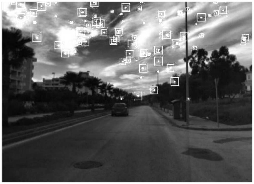
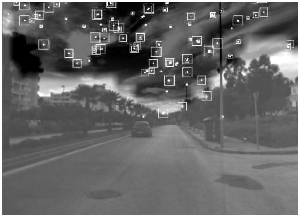
[0129] Visual information processing module: It is used to collect the image of the area in front of the carrier, and after semantic segmentation, the area ratio of the sky area in the original image is obtained, and the pose data is further obtained;

[0130] Adaptive fusion module: obtain the estimated pose after filtering by dynamically adjusting the estimated weight of GPS data in the Kalman filter fusion process based on the proportion of the sky area in the original image;

[0131] The above modules are all arranged on the same carrier.


PUM


Abstract

The invention discloses a self-adaptive GPS fusion positioning system and method and a medium. The system comprises a GNSS / INS information acquisition module, a visual information processing module and a self-adaptive fusion module. The GNSS / INS information acquisition module comprises a global satellite navigation system and an inertial navigation system; the visual information processing module is used for collecting an image of an area in front of a carrier, obtaining an area proportion of a sky area in an original image after semantic segmentation, and further obtaining pose data; the self-adaptive fusion module is used for dynamically adjusting the estimation weight of the GPS data in the fusion process of the Kalman filtering according to the area proportion of the sky area in the original image, and obtaining the filtered estimation pose; according to the method, mismatching of the sky area in visual pose estimation can be removed, and the mobile robot can obtain better pose estimation when in an urban canyon state.

Description

technical field [0001] The invention relates to the field of data fusion positioning, in particular to an adaptive GPS fusion positioning system, method and medium. Background technique [0002] In a multi-sensor information fusion system, each sensor will measure different parameters. However, the measured values ​​obtained are not only affected by the sensor's own manufacturing structure and information collection method, but also by environmental factors. GPS is a sensor that is easily affected by the environment. It cannot receive satellite signals indoors and thus cannot calculate the current position. However, when it is outdoors, the signal may still be blocked or interfered. This situation often occurs. Appears in the environment of urban canyons, because the high-rise buildings in the city will block the received signal of GPS, resulting in poor satellite tracking accuracy; the camera is a relatively stable sensor, but its positioning accuracy will be subject to som...

Claims


Application Information

Patent Timeline
Patent Type & Authority Applications(China)
IPC IPC(8): G01S19/45G01S19/39G01S19/47G01C21/16G01C21/00G06T7/70G06V10/26
CPCG01S19/45G01S19/393G01S19/47G01C21/165G01C21/005G01C21/1656G06T7/70
Inventor 叶峰李廓赖乙宗
Owner SOUTH CHINA UNIV OF TECH
Features
  • R&D
  • Intellectual Property
  • Life Sciences
  • Materials
  • Tech Scout
  • Unparalleled Data Quality
  • Higher Quality Content
  • 60% Fewer Hallucinations
Learn More