Annular region recommendation point algorithm based on elevation

A ring area and algorithm technology, applied in the algorithm field, can solve the problems of low efficiency and achieve the effect of improving elevation accuracy and accurate pixel position

Pending Publication Date: 2022-07-01
成都众享天地网络科技有限公司
View PDF0 Cites 0 Cited by
  • Summary
  • Abstract
  • Description
  • Claims
  • Application Information

AI Technical Summary

Problems solved by technology

[0005] The technical problem to be solved by the present invention is that a reasonable location needs to be selected when the equipment is arranged with the center of the position as the center of the circle. The purpose of this document is to provide an elevation-based circular area recommendation point algorithm to solve the above problems

Method used


Image

  • Annular region recommendation point algorithm based on elevation

Examples


Embodiment

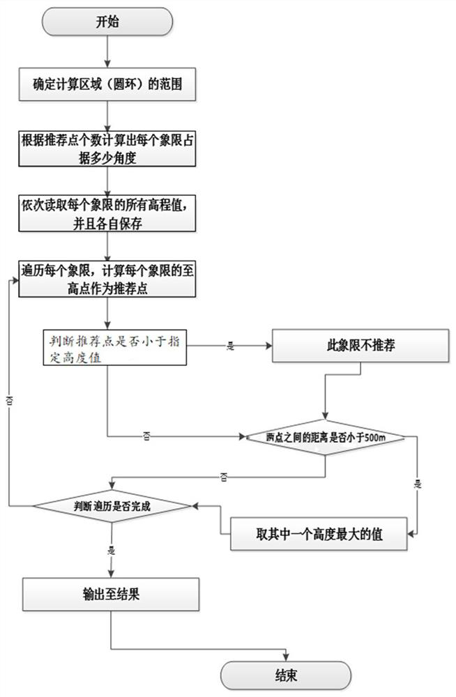
[0018] like figure 1 As shown, a kind of elevation-based annular region recommendation point algorithm of the present invention, is characterized in that, described algorithm comprises the steps: S1: obtain parameter area center data, start radius data and end radius data, according to input parameter area center, The start radius and end radius determine the area range of the ring; S2: Divide the ring into n quadrants by inputting the recommended number of parameters, and read the elevation value of each quadrant in turn. The elevation value of each quadrant is determined by relative Calculate the latitude and longitude of each point based on the azimuth and distance of the center of the area, and then read all the elevation values ​​in each quadrant; S3: traverse each quadrant, and have read the elevation values ​​of each quadrant through step S2, and then sequentially Calculate the highest point of each quadrant, and use this as the recommended point; S4: judge whether the ...


PUM


Abstract

The invention discloses a circular ring region recommendation point algorithm based on elevation, and the algorithm comprises the following steps: S1, obtaining parameter region center data, starting radius data and ending radius data, and determining the region range of a circular ring according to the input parameter region center, starting radius and ending radius; s2, equally dividing the circular ring into n quadrants by inputting the number of parameter recommendation points, sequentially reading the elevation value of each quadrant, calculating the longitude and latitude height of each point according to the elevation value of each quadrant through the azimuth angle relative to the center of the region and the distance, and then reading all the elevation values in each quadrant; s3, traversing each quadrant, sequentially calculating a high point of each quadrant according to the elevation value of each quadrant read in the step S2, and taking the high point as a recommended point; and S4, judging whether the recommendation point of the current quadrant is smaller than the specified height, and if so, not recommending the quadrant.

Description

technical field [0001] The invention relates to an algorithm, in particular to an elevation-based algorithm for recommending points in an annular area. Background technique [0002] With the development of technology, the new generation of radar has put forward higher requirements for the conditions of the site terrain, requiring a smaller shielding angle and a larger and flatter site reflector. Therefore, the terrain survey and actual lobe analysis of the radar site Ability puts forward higher requirements. [0003] At present, the method used for terrain measurement of radar positions is mainly total station + GPS, and the total station is mainly used in the measurement of shading angle. Manual observation is carried out every one degree. By adjusting the inclination angle of the eyepiece of the total station, aiming at the highest point of the obstacle, and recording the inclination of the eyepiece, the shielding angle is obtained. The paper-based radar position shieldi...

Claims


Application Information

Patent Timeline
Patent Type & Authority Applications(China)
IPC IPC(8): G06F16/29G06T17/05G06T7/62G06T7/73
CPCG06F16/29G06T17/05G06T7/62G06T7/75
Inventor 孙成刚岳红霞张剑锋周武林唐庆生吴翠
Owner 成都众享天地网络科技有限公司
Why Eureka
Try Eureka