Positioning method for manned submersible without fixed reference point

A manned submersible and inertial coordinate system technology, which is applied in the field of manned submersible positioning in the ocean, can solve the problems of fixed underwater acoustic beacons such as troublesome tracking range, and achieve the effect of avoiding the loss of underwater acoustic beacons.

Inactive Publication Date: 2006-05-31
SHENYANG INST OF AUTOMATION - CHINESE ACAD OF SCI
View PDF0 Cites 9 Cited by
  • Summary
  • Abstract
  • Description
  • Claims
  • Application Information

AI Technical Summary

Problems solved by technology

[0007] In order to avoid the trouble of launching a fixed underwater acoustic beacon and solve the problem of a small tracking range, the present invention provides a brand new positioning method for a manned submersible without a fixed reference point in the inertial coordinate system

Method used


Image

  • Positioning method for manned submersible without fixed reference point
  • Positioning method for manned submersible without fixed reference point
  • Positioning method for manned submersible without fixed reference point

Examples


Embodiment Construction

[0026] The present invention will be further described below.

[0027] The invention adopts the ultra-short baseline positioning system to determine the coordinates of the manned submersible in the inertial coordinate system, without dropping fixed underwater acoustic beacons on the sea surface or sea bottom. specifically is:

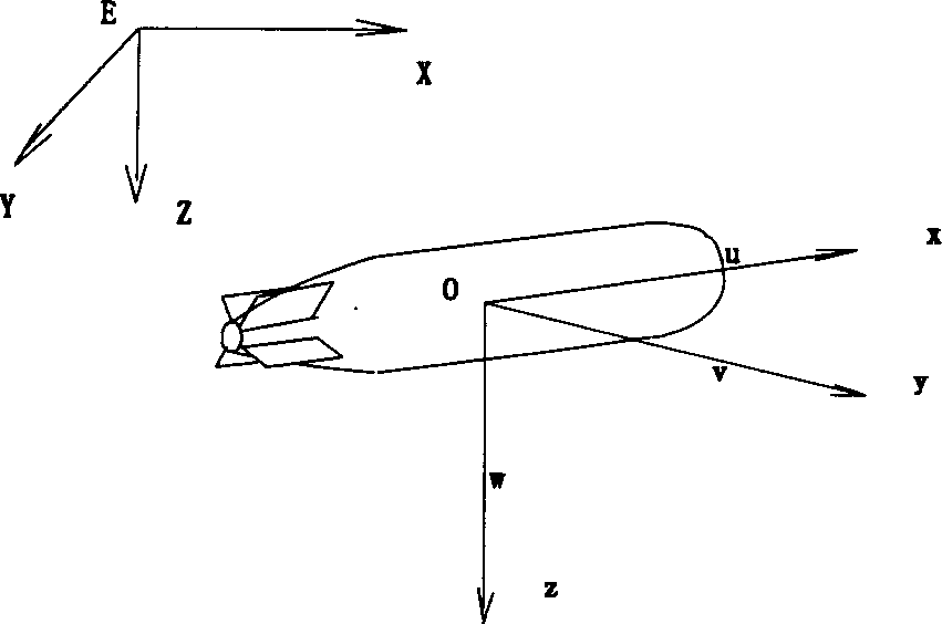
[0028] First of all, a fixed coordinate system (E-XYZ) must be determined, and the origin is E. Wherein, EZ points to the center of the earth, and the horizontal plane adopts the northeast coordinate system. In this embodiment, the mother ship is taken as the origin E of the fixed coordinate system. In addition, the dynamic coordinate system (o-xyz) must be defined, and the dynamic coordinate system is fixedly connected with the manned submersible. Such as figure 1 As shown, in principle, the origin of the moving coordinate system and the direction of the coordinate axes can be selected arbitrarily. For the sake of convenience, in this embodiment, th...


PUM


Abstract

A positioning method in inertial coordinate system of manned submersible with no fixed reference point includes confirming a fixed coordinate first then confirming inertial coordinate at certain time of mother ship and manned submersible, using position at this certain time of manned submersible as initial value to carry out flight trace calculation of manned submersible and then converting each coordinate of manned submersible to be coordinate in inertial coordinate system.

Description

technical field [0001] The present invention relates to the positioning technology of a manned submersible in the ocean, specifically a positioning method for a manned submersible without a fixed reference point in an inertial coordinate system. coordinates, determine the coordinates of the manned submersible in the inertial coordinate system. technical background [0002] When the manned submersible is moving in the ocean, not only the relative position between the manned submersible and the operating mother ship needs to be determined in real time, but also the coordinates of the manned submersible in the inertial coordinate system need to be determined in real time. In the past, to determine the coordinates of a manned submersible in the inertial coordinate system, it was necessary to place an acoustic hydroacoustic response beacon at a fixed position on the seabed or on the sea surface. The underwater acoustic receiving base array determines the coordinates of the fixed...

Claims


Application Information

Patent Timeline
Patent Type & Authority Applications(China)
IPC IPC(8): G01S15/60G01C21/00
Inventor 于开洋
Owner SHENYANG INST OF AUTOMATION - CHINESE ACAD OF SCI
Why Eureka
Try Eureka