Method for safety early warning for track curve and recording journey in navigation system

A navigation system and safety warning technology, applied in the field of navigation systems, can solve problems such as insufficient driving back-end services, wrong judgments by drivers, and high risk

Active Publication Date: 2006-07-05
IND TECH RES INST
View PDF1 Cites 24 Cited by
  • Summary
  • Abstract
  • Description
  • Claims
  • Application Information

AI Technical Summary

Problems solved by technology

[0003] Recently, the functions of the navigation system have been improved, and there are more sufficient guidance for the road conditions ahead, such as providing guidance on the legal maximum speed limit ahead, or capturing the shape of the intersection ahead, and displaying and zooming in, or guidance on the curve ahead, To provide the highest safe speed limit under this curve condition; for the design of the highest safe speed limit under the aforementioned curve conditions, such as US Patent No. 5,315,295 "VEHICLE SPEED CONTROL SYSTEM" is to use coordinate detection devices, road surface temperature sensors, After the road humidity sensor and speed sensor detect relevant information, they send back to the internal CPU for "real-time calculation (real-time calculatio

Method used


Image

  • Method for safety early warning for track curve and recording journey in navigation system
  • Method for safety early warning for track curve and recording journey in navigation system
  • Method for safety early warning for track curve and recording journey in navigation system

Examples


Embodiment Construction

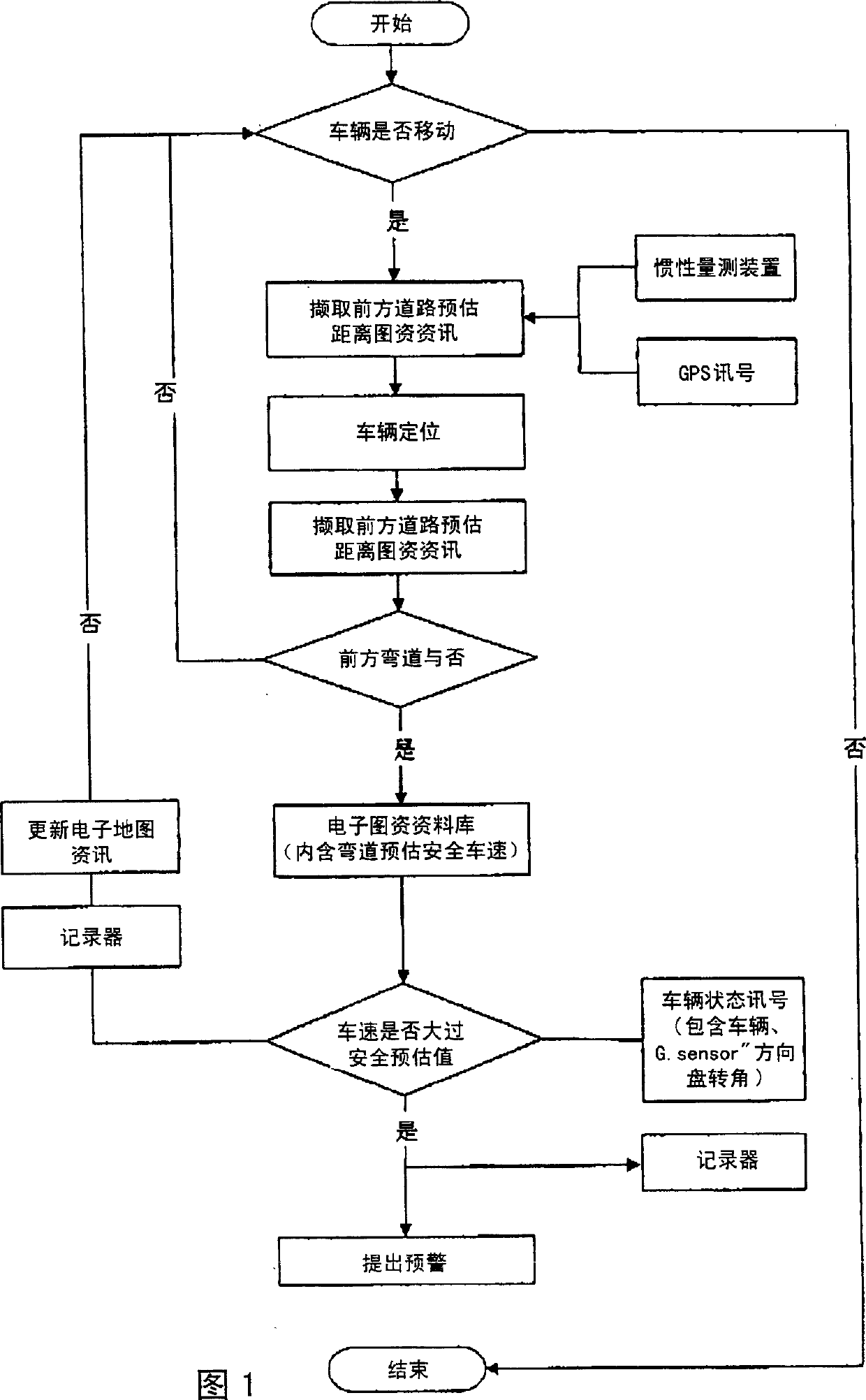
[0028] A curve safety early warning and driving recording method of a navigation system of the present invention, first in the curve safety early warning method:

[0029] Step 1: Create map information:

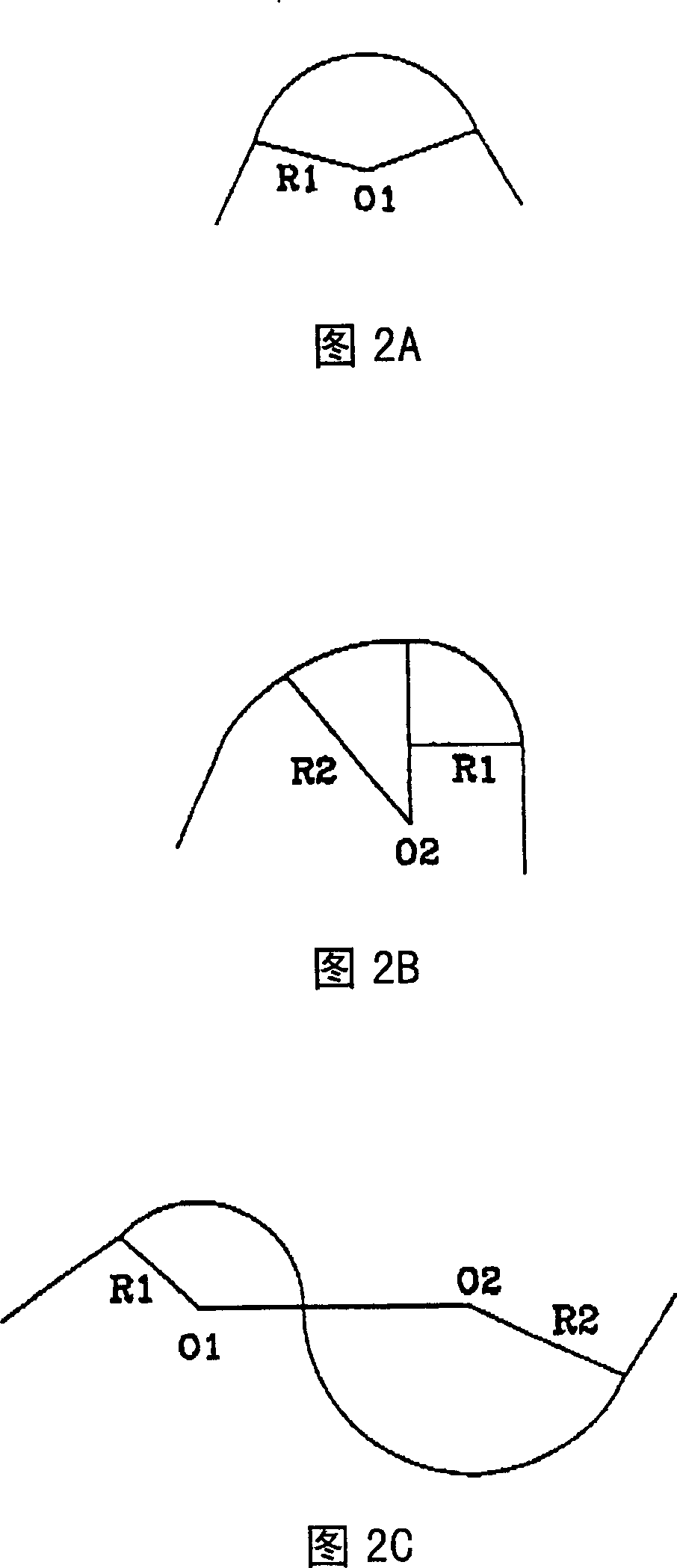
[0030] (A) at first with all roads in the regional map data, first define the single curve as shown in Figure 2A, or the compound curve as Figure 2B and or three kinds of curve combinations such as the reverse curve as Figure 2C;

[0031] (B) Define the weight of the vehicle first, and define the average outer rail superelevation rate and road surface μ value at each coordinate point according to the road engineering design specifications;

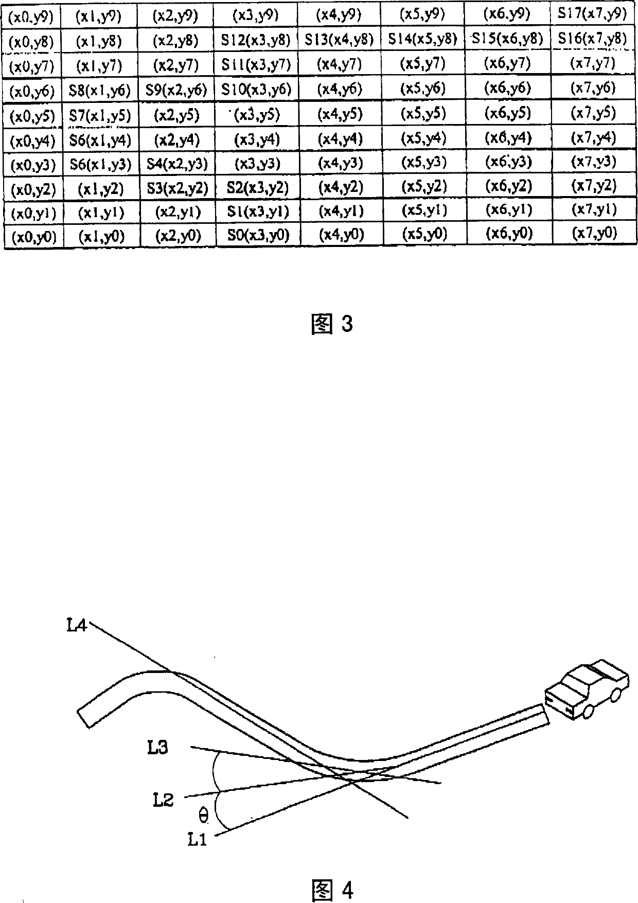
[0032] (C) As shown in Figure 3 and Figure 4, as shown in Figure 3, a total of 18 points are taken out of the example road section, that is, by S 0 to S 17 ; And according to the above combination of curves, calculate the angle between two adjacent straight lines; for example, take L1 as S 0 (X 0 , Y 0 ) to S 1 (X 1 , Y 1 ), where...


PUM


Abstract

The invention is a bend safety precaution method for a navigation system, for avoiding the damage in safety caused by fatigue or carelessness during driving in a vehicle, using GPS to learn the current coordinate point of the vehicle and using inertia measurer to learn the vehicle advancing direction, and taking a distance before the current coordinate point as a preestimated distance, comparing the current vehicle speed with the safe vehicle speed prestored in an electronic map within the preestimated distance: if the vehicle speed exceeds the safe vehicle speed, making an caution; and besides, completely recording actual vehicle speed, rotating angle of steering wheel, GPS coordinate point and time.

Description

technical field [0001] The invention relates to a navigation system, in particular to a curve safety early warning and driving recording method of the navigation system. Background technique [0002] As far as transportation is concerned, more and more users are gradually relying on navigation systems to guide driving routes and place names; however, the road information of many early navigation systems only uses images to display information. , without any guidance, so that this kind of navigation system can only provide a reference for driving direction, and its navigation value is low. [0003] Recently, the functions of the navigation system have been improved, and there are more sufficient guidance for the road conditions ahead, such as providing guidance on the legal maximum speed limit ahead, or capturing the shape of the intersection ahead, and displaying and zooming in, or guidance on the curve ahead, To provide the highest safe speed limit under this curve conditi...

Claims


Application Information

Patent Timeline
IPC IPC(8): G01C21/26G01C21/16G01S5/02G08G1/00G01S19/42
Inventor 简昌浚苏评挥黄立恭陈隆泰
Owner IND TECH RES INST
Why Eureka
Try Eureka