Celestial navigation using laser communication system

a laser communication and navigation technology, applied in the field of laser communication, can solve the problems of reducing the accuracy of the platform ins b>4/b>, the imu is not as accurate as the platform ins located elsewhere, and the platform is b>4/b> oriented much less accurately, so as to reduce the acquisition fou and quick establish the initial link

Active Publication Date: 2018-12-18
BAE SYST INFORMATION & ELECTRONICS SYST INTERGRATION INC
View PDF15 Cites 9 Cited by
  • Summary
  • Abstract
  • Description
  • Claims
  • Application Information

AI Technical Summary

Benefits of technology

[0004]One issue with the current state of the art in laser communications systems is the length of time, typically minutes, required for one vehicle or satellite to establish an initial laser communication link with a corresponding satellite / vehicle. Thus, a need exists for a solution to more quickly establish the initial link between satellites and / or airborne vehicles in high altitude environments. The present disclosure addresses this and other issues by making use of the ATS that is native to the laser communication system to also perform a star tracker celestial navigation fix to greatly reduce the acquisition FOU. This reduction of the FOU enables rapid acquisition and establishment of the laser link between the two platforms. This is an exemplary benefit of this patent disclosure. Another exemplary benefit is the use of the ATS as a star tracker for the precision position and attitude determination required to establish the laser communication link, without the need for the Global Positioning System (GPS). Thus, the celestial fix obtained with the integrated ATS enables the laser communication link to be rapidly established, even in a degraded or denied GPS environment, and without the need and expense of a separate star tracker.

Problems solved by technology

This acquisition sequence for searching the FOU 5 takes 1 to 10 minutes for typical uncertainty volumes based on GPS position data, which is generally very good, but the platform INS 4 attitude accuracy is generally much less accurate.
However, the laser communication payload with its IMU and ATS, and the platform INS are not typically co-located on the platform, but are separated by a substantial distance.
But, the IMU is not as accurate as the platform INS located elsewhere in the aircraft or satellite.
Another point relating to transfer alignment is that vibration varies at different mounting locations on the platform, and disturbances such as aircraft lifting forces or wind loads, or satellite g-release forces can cause slight bending of the platform.
However, the platform INS lacks the ability to determine the high frequency vibration experienced elsewhere at the laser communications payload, because as the separation increases the jitter and the physical bending of structure / frame sensed at the laser communications payload IMU is very different from what the remotely located platform INS is sensing.
However, there are inherent measurement inaccuracies and errors associated with the transfer alignment process that blends the precise, low frequency data from the platform INS with the local high frequency data from the laser communication payload IMU.
Thus, the beam director optical encoders reduce the absolute pointing accuracy associated with the payload-pointing gimbals.
Daytime sky radiance is more challenging than acquisition against a night sky.
Unlike a space craft star tracker or night observations on the ground, a challenge exists that an airborne star tracker must also be viable during daylight hours.

Method used


Image

  • Celestial navigation using laser communication system
  • Celestial navigation using laser communication system
  • Celestial navigation using laser communication system

Examples


Embodiment Construction

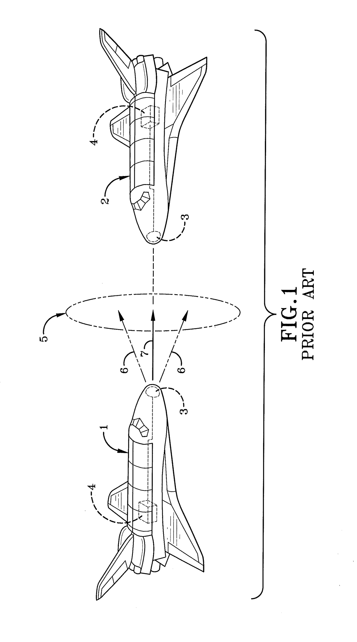
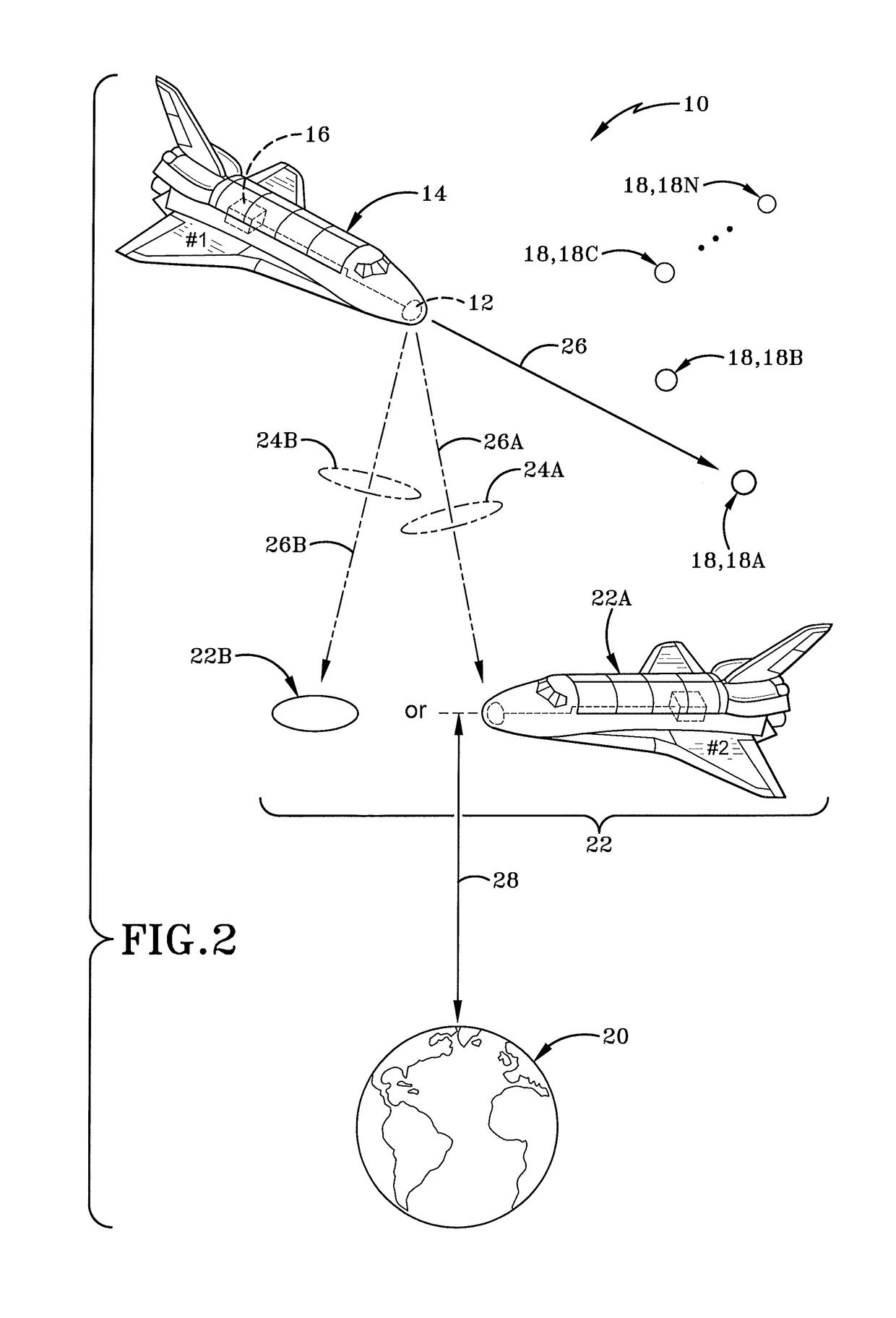
[0015]By way of additional background, and in accordance with one aspect of an embodiment, the present disclosure may provide a laser communication system for air-to-air (i.e., vehicle-to-vehicle), air-to-satellite (i.e., vehicle-to-satellite), or satellite-to-satellite laser links. In each scenario, the laser communication system of the present disclosure operates at high altitudes above atmospheric clouds, or in outer space. Regarding the laser communication link established between the vehicles / satellites, the communications over the laser could be anything similar to what is conventionally sent over an RF link between platforms (i.e. vehicles or satellites). Generally, the communication includes sensor data from surveillance sensors or earth resources / imaging. Typically the sensor data needs to go from one airborne or satellite platform to another airborne platform or satellite.

[0016]The laser beam within the laser communication system carries this prime mission sensor data or o...


PUM


Abstract

A laser communication system its integrated microradian-accuracy Acquisition and Tracking Sensor (ATS) to perform a celestial navigation fix to determine the attitude of the laser communications payload, including the integrated ATS and the co-boresighted laser beam, prior to establishing a laser communication link with a second vehicle such as a high-altitude aircraft or satellite. The laser communication system may use a legacy platform INS to initially point its narrow FOV ATS at one or more stars to obtain the vehicle's attitude therefrom. Then the precision payload attitude determined with the ATS star tracker fix is used to point the co-boresighted laser beam to establish a laser communications link with the second vehicle.

Description

BACKGROUNDTechnical Field[0001]The present disclosure relates generally to laser communication between high-altitude aircraft or space systems. More particularly, the present disclosure in one embodiment relates to a laser communication system that utilizes its embedded Acquisition and Tracking Sensor (ATS) to observe one or more stars to precisely establish the first vehicle position and attitude to enable the pointing of a very narrow laser communication beam at a second vehicle, based on the first vehicle precision attitude knowledge.Background Information[0002]One of the key technologies for optical inter-satellite communication equipment is the highly accurate acquisition and tracking of the corresponding satellite or vehicle. An integrated Acquisition and Tracking Sensor (ATS) that is part of a laser communication system on high altitude vehicles, such as spacecraft, aircraft, and satellites, enables laser-based optical inter-vehicle communication. The ATS position and jitter ...

Claims


Application Information

Patent Timeline
Patent Type & Authority Patents(United States)
IPC IPC(8): H04B10/118G01C21/02B64G3/00G01S3/786G01S5/16G01C21/16
CPCH04B10/118B64G3/00G01S5/163G01C21/165G01S3/7867G01C21/025
Inventor CARLSON, ROBERT T.
Owner BAE SYST INFORMATION & ELECTRONICS SYST INTERGRATION INC
Why Eureka
Try Eureka