Method and apparatus for building and maintaining an object-oriented geospatial database

a geospatial database and object-oriented technology, applied in the field of database construction and maintenance, can solve the problems of time-consuming and subsequently restrictive processing, limited vpf software offered by niia, and limited to simple map viewing, etc., and achieve the effect of easy data expor

Inactive Publication Date: 2005-04-28
THE UNITED STATES OF AMERICA AS REPRESENTED BY THE SECRETARY OF THE NAVY
View PDF1 Cites 110 Cited by
  • Summary
  • Abstract
  • Description
  • Claims
  • Application Information

AI Technical Summary

Benefits of technology

[0026] A primary object of the present invention is to provide a geospatial query and update mapping system that permits easy exporting of data from an object-oriented geospatial database to a relational VPF database.

Problems solved by technology

The VPF software offered by NIIA is limited to simple map viewing.
While VPFView can be used to query the VPF database, it is limited to simple inquiries because VPFView was never designed to perform sophisticated GIS functions.
Further, access to VPF data through non-NIMA software, such as ESDI's ArcView, often requires prior translation of the VPF database, a process both time-consuming and subsequently restrictive to whatever version of the VPF database existed at the time of translation.
Additionally, use of the VPF to dynamically analyze topological information is not possible with any VPF-compatible system presently available.
If the user desires to view and analyze geospatial information in the absence of the bridge, the underlying relational VPF database must first be modified to change the existence attribute for this particular feature—a complex and time-consuming process that requires the updating of all related tables and files.
These complexities place a heavy burden on the maintenance of topological relationships following changes in feature data, especially in a relational database such as the VPF database.
Furthermore, because of the number of tables involved, maintaining referential integrity of the VPF database upon an update is very difficult.
This difficulty arises because the VPF format relies on data residing within multiple specialized tables on multiple levels of the VPF relational database.
Although applications exist to view geospatial data in any of the VPF, RPF, and TPS data formats, no single software product exists to view, query, or manipulate all three formats on a one platform.
Cross-referencing data produced in different formats is difficult at best, thereby limiting the speed of assimilating the data and limiting the ability to query and display data from a variety of sources.

Method used


Image

  • Method and apparatus for building and maintaining an object-oriented geospatial database
  • Method and apparatus for building and maintaining an object-oriented geospatial database
  • Method and apparatus for building and maintaining an object-oriented geospatial database

Examples


Embodiment Construction

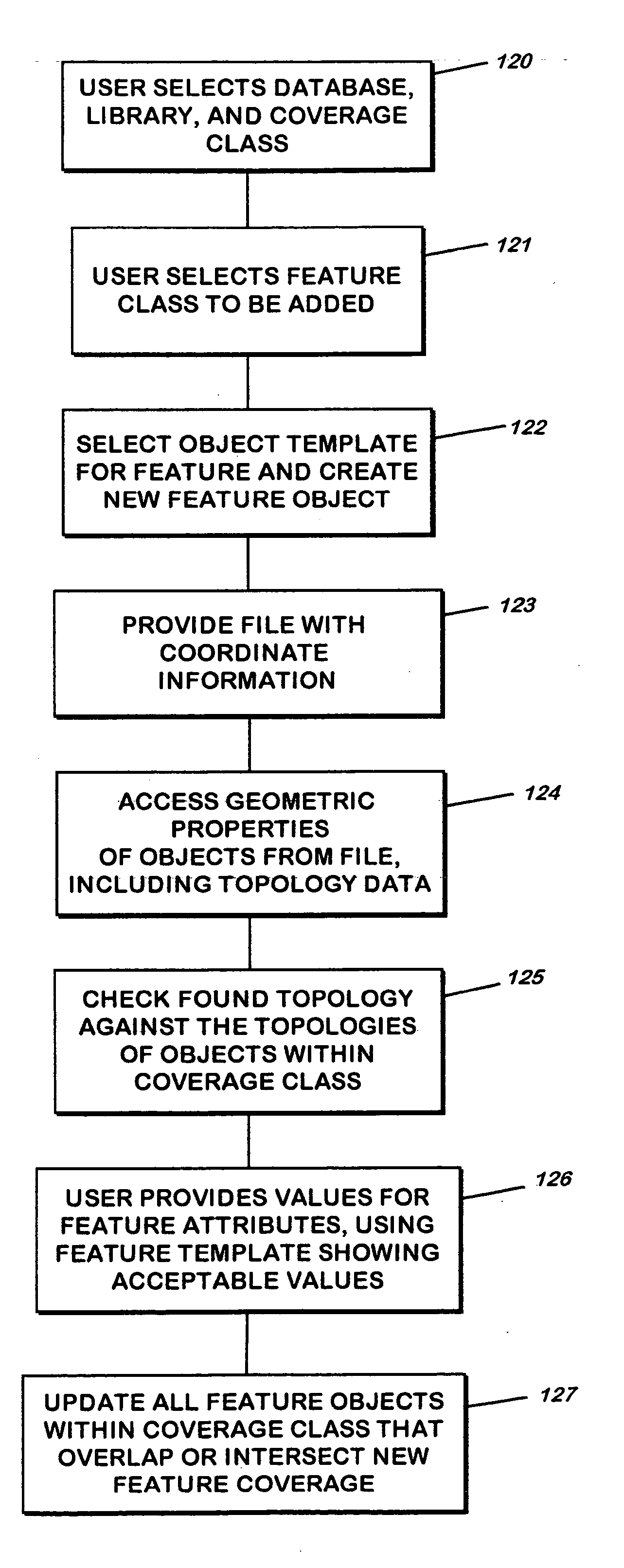
[0056] A preferred embodiment of the invention is readily implemented on existing hardware-independent processing platforms with sufficient computer-readable storage for building, maintaining, and querying a sufficiently large object-oriented database to support the data of a VPF file.

[0057] At a threshold level, it may be helpful to discuss some of the basic distinctions between the object-oriented approach to data storage and retrieval and the georelational approach as is found in the present relational VPF data structure. In the georelational approach, all data is organized into tables of rows and columns, and a given row's identity is based on its primary and secondary key values. Query and analysis procedures are external to the data tables and are maintained independently of them. As the data structures change, so must the query and analysis procedures. Also, as the data structures become more complex, keeping the data synchronized with each other through an updating process ...


PUM


Abstract

An object-oriented system for building and maintaining a spatial data structure for use in topological applications. The data is organized in a database which incorporates spatial feature location, attributes, and metadata information in a relational framework across a hierarchy. The system provides for the instantiation of the objects and levels that make up the database and for spatially indexing the data among the objects across hierarchical levels. The data can be updated while preserving the spatial linking among objects and levels, and the data can be exported to a relational vector product format database.

Description

BACKGROUND OF THE INVENTION [0001] 1. Field of the Invention [0002] The present invention relates to database construction and maintenance within object-oriented programming paradigms. More specifically, the invention relates to a method and apparatus for building and maintaining an object-oriented database of geospatial data for use with the development and maintenance of topological maps consistent with the Vector Product Format, Raster Product Format, and Text Product Standard developed for use by the U.S. Defense Mapping Agency, now known as the National Imagery and Mapping Agency. [0003] 2. Description of the Related Art [0004] The use of maps and geographical characteristics has expanded well beyond the navigator, the cartographer, and the classroom the independent field of topology, which is the study of the characteristics, such as adjacency and contiguity, of geometrical objects that are independent of the underlying coordinate system. The primary purpose for providing topo...

Claims


Application Information

Patent Timeline
Patent Type & Authority Applications(United States)
IPC IPC(8): G06F17/30
CPCG06F17/30241G06F17/30607Y10S707/915Y10S707/917Y10S707/99944Y10S707/99943G06F16/29G06F16/289
Inventor SHAW, KEVIN B.CHUNG, MIYI J.COBB, MARIA A.
Owner THE UNITED STATES OF AMERICA AS REPRESENTED BY THE SECRETARY OF THE NAVY
Why Eureka
Try Eureka