Intelligent interpolation methods for automatic generation of an accurate digital elevation model

an automatic generation and digital elevation technology, applied in the field of intelligent interpolation methods for automatic generation of accurate digital elevation models, can solve the problems of insignificant interpolation effect and the inability to apply the method to the area with open boundaries

Inactive Publication Date: 2002-03-21
KOREA ADVANCED INST OF SCI & TECH
View PDF4 Cites 9 Cited by
  • Summary
  • Abstract
  • Description
  • Claims
  • Application Information

AI Technical Summary

Problems solved by technology

For a manually generated DEM, interpolation is necessary, but the effect of interpolation is insignificant.
Since the CIMs handle less than a few hundreds of input data as an experimental trial, following problems show up when the CIMs are applied to the results of the real data; artificial lands are created with the size of the interpolation radius near coast, breakwater, lake, and river.
However, this method can not be applied to the areas with open boundaries such as the sea off the coast and a river.

Method used


Image

  • Intelligent interpolation methods for automatic generation of an accurate digital elevation model
  • Intelligent interpolation methods for automatic generation of an accurate digital elevation model
  • Intelligent interpolation methods for automatic generation of an accurate digital elevation model

Examples


Embodiment Construction

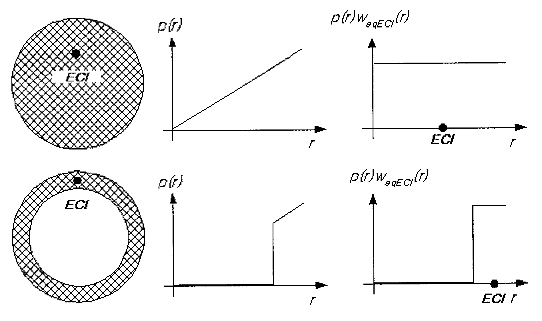
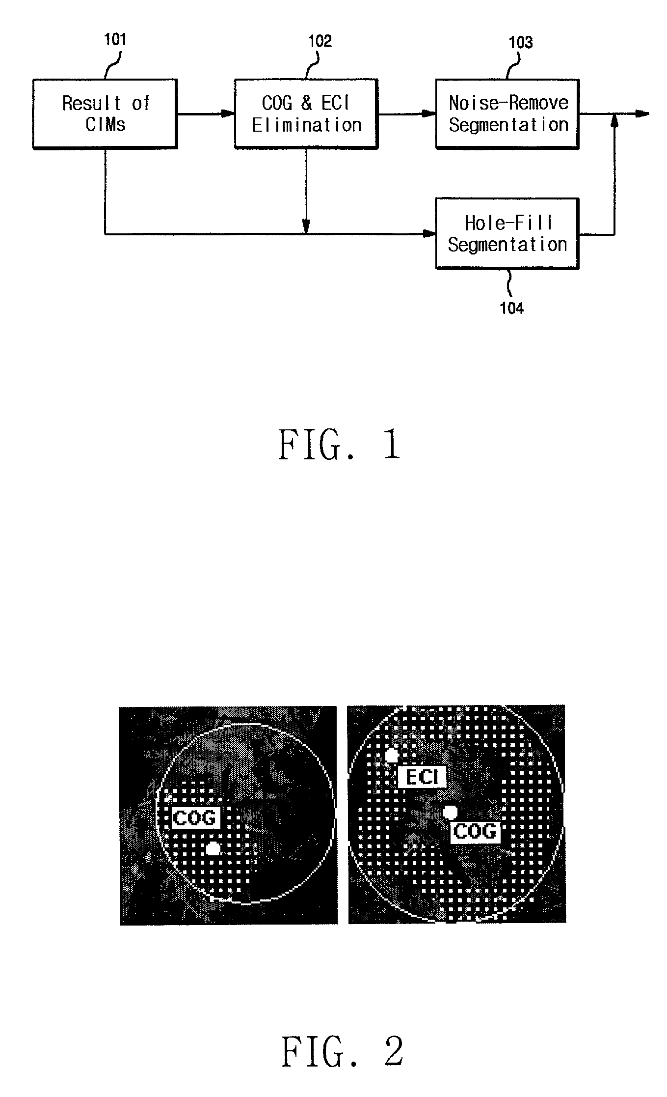
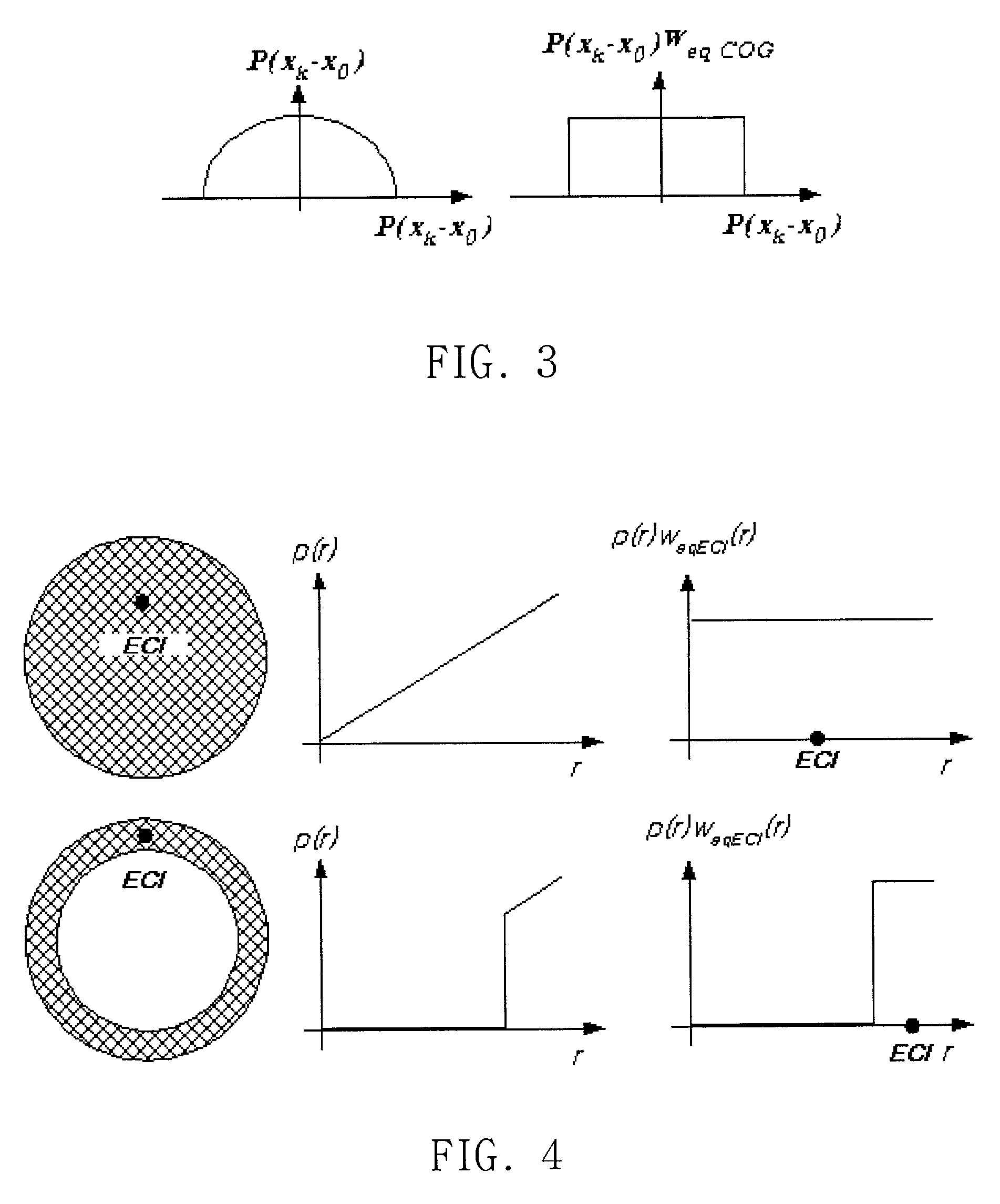
[0027] The present invention will be better understood with regard to the following description, appended claims, and accompanying figures. The present invention is composed of three basic processes: In the first process (102) of COG / ECI elimination, the artificial elevation from the result (101) of the conventional interpolation methods is eliminated if the corresponding COG or ECI is greater than a threshold. In the second process (104) of hole-fill segmentation, the eliminated region after the first process (102) is segmented, and it is decided whether the eliminated elevation should be reconstructed based upon the size of the segment. And in the third process (103) of noise-remove segmentation, the interpolated region after the first process (102) is segmented, and it is decided whether the interpolated elevation should be eliminated based upon the size of the segment.

[0028] As mentioned earlier, when the CIMs are used, artificial lands are created with the size of the interpola...


PUM


Abstract

The present invention relates generally to interpolation methods for automatic generation of an accurate digital elevation model, and more particularly relates to intelligent interpolation methods for accurate extraction of 3-dimensional digital elevation models from satellite images, aerial photographs, or land surveying. The present invention is composed of three basic processes: The first process (102) of COG / ECI elimination, the second process (104) of hole-fill segmentation, and the third process (103) of noise-remove segmentation. The invention produces an accurate digital elevation model even for the areas with open boundaries such as the sea off the coast and over a river.

Description

[0001] 1. Field of the Invention[0002] The present invention relates generally to interpolation methods for automatic generation of an accurate digital elevation model, and more particularly relates to intelligent interpolation methods for accurate extraction of 3-dimentional digital elevation models from satellite images, aerial photographs, or ground surveying.[0003] 2. Description of the Related Art[0004] Digital elevation model (DEM) is the topographic data composed of the set of horizontal coordinates (x, y) and its elevation (z) for each grid cell in a given region. The process of DEM can be summarized in three steps; (1) image-matching step to find overlapped regions from stereo images, (2) camera-modeling step to obtain (x,y,z) from the results of the image-match with a camera model relating the photo plane with the absolute ground coordinates, and (3) interpolation step to change the uneven horizontal distribution resulted from camera-model into the uniform horizontal squar...

Claims


Application Information

Patent Timeline
Patent Type & Authority Applications(United States)
IPC IPC(8): G01C11/00G06T5/00G06T17/05
CPCG01C11/00G06T7/0075G06T17/05G06T2207/10028G06T2207/10032G06T2207/30181G06T7/593Y02A90/30G06T5/00
Inventor KIM, SEUNG BUMKIM, TAG GON
Owner KOREA ADVANCED INST OF SCI & TECH
Why Eureka
Try Eureka