Region calculation method, spatial data mining apparatus, geographical information display apparatus, spatial data mining system and storage medium

Inactive Publication Date: 2002-05-16
IBM CORP
View PDF7 Cites 24 Cited by
  • Summary
  • Abstract
  • Description
  • Claims
  • Application Information

AI Technical Summary

Problems solved by technology

But since present day spatial data mining requires expensive spatial/geometrical calculations involving a huge amount of data, and since extremely difficult technical problems are frequently encountered, spatial

Method used


Image

  • Region calculation method, spatial data mining apparatus, geographical information display apparatus, spatial data mining system and storage medium
  • Region calculation method, spatial data mining apparatus, geographical information display apparatus, spatial data mining system and storage medium
  • Region calculation method, spatial data mining apparatus, geographical information display apparatus, spatial data mining system and storage medium

Examples


Embodiment Construction

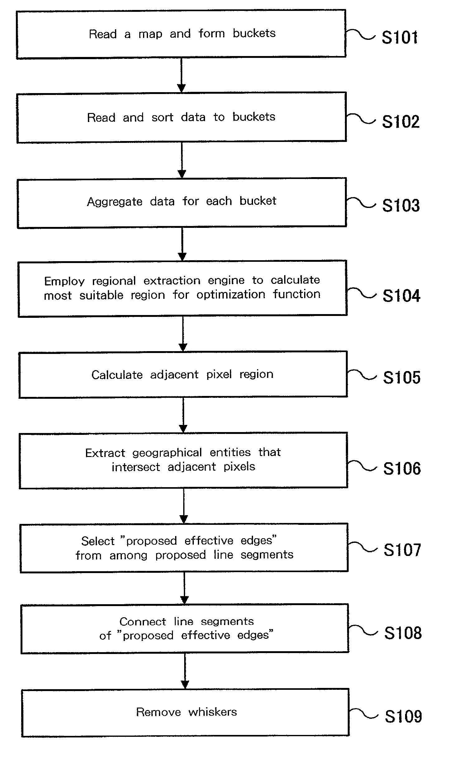
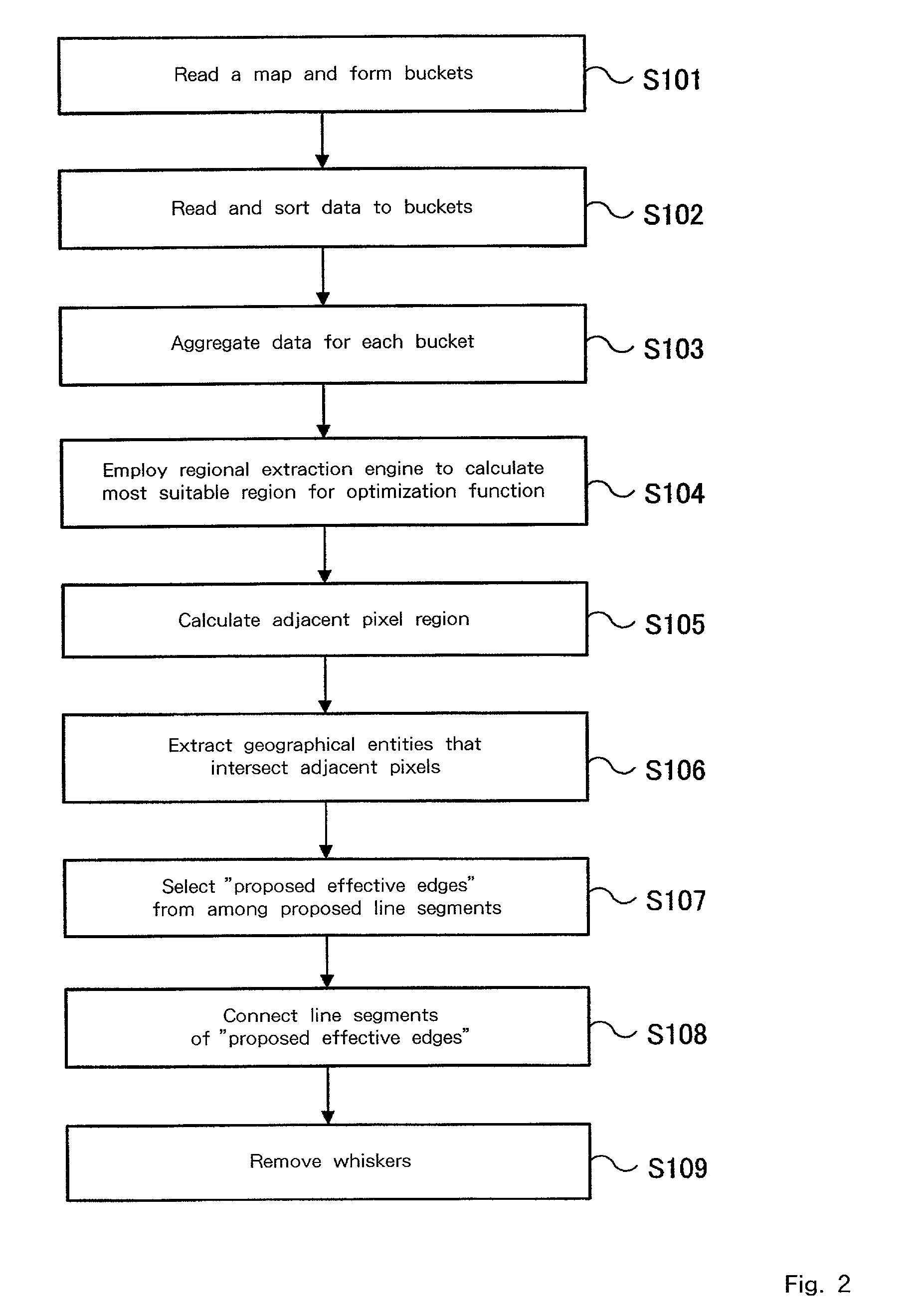
[0029] The preferred embodiment of the invention will now be described in detail while referring to the accompanying drawings.

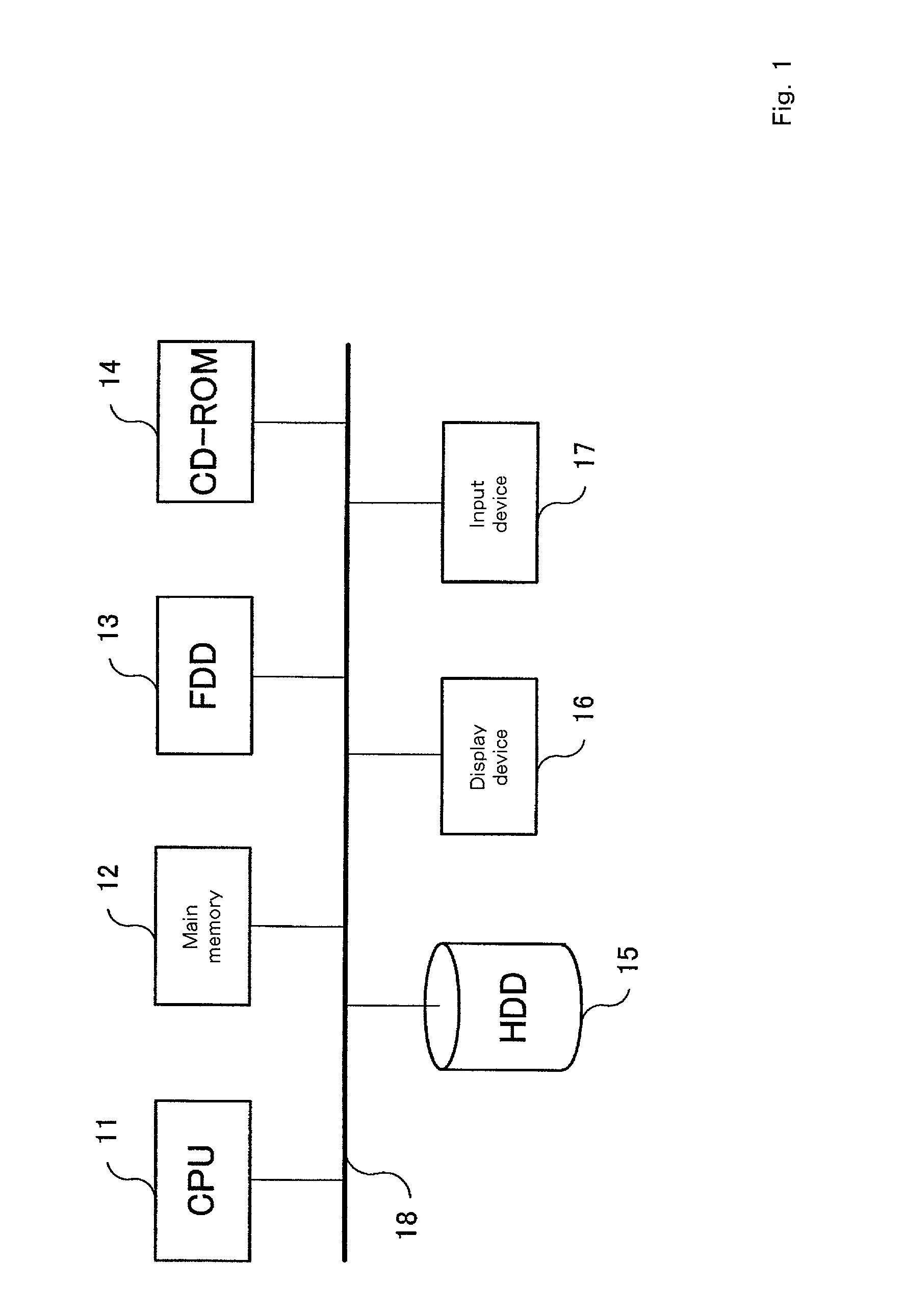
[0030] FIG. 1 is a schematic diagram for explaining a computer system that, according to the embodiment of the invention, implements an optimal region calculation method. The processing algorithm for this embodiment is contained in a program that is executed by a computer system shown in FIG. 1. The processing program is stored on a hard disk drive (HDD) 15, and is loaded into a main memory 12 whereat it is executed by a CPU 11. This processing program is then used to access a large database, which is also recorded on the HDD 15, in which are stored data that are used as geographical information for a GIS (Geographical Information System) screen, special data for geographical entities depicted on a map, such as lakes, seas, forests, roads and rivers, address information, and customer data, consisting of the total value of recorded sales and annual income info...


PUM


Abstract

It is one object of the present invention to perform regional optimization while taking spatial continuity into account, and to provide higher-level spatial data mining. A region calculation method for introducing a two-dimensional association rule, extracted from a database, that includes spatial information, such as addresses, and for applying the two-dimensional association rule for a map, comprises the steps of: defining an objective function that is used to introduce the two-dimensional association rule and that does not include regional information for which an output request has been submitted; dividing a region on the map into w pixel grids having a predetermined size to form buckets (S101); aggregating data available in the database for each bucket (S103); employing the objective function to calculate a region for the optimization of the objective function (S104); extracting entities, appearing on the map, that correspond to the obtained region (S106); and employing the extracted entities to output a region that is applied for the map.

Description

[0001] 1. Field of the Invention[0002] The present invention relates to database processing for spatial data mining, and relates more specifically to a method and an apparatus for the calculation of an optimal region, which is the basic function of spatial data mining.[0003] 2. Background Art[0004] A new processing technique has been introduced whereby spatial information, such as address data, in large databases can be interpreted by applying spatial context and spatial rules. But since present day spatial data mining requires expensive spatial / geometrical calculations involving a huge amount of data, and since extremely difficult technical problems are frequently encountered, spatial data mining has not been well studied and remains an underdeveloped field. However, spatial data mining is considered to be a feasible basic technique that can greatly assist in the development of databases capable of handling huge volumes of business data for the information industry or for the GIS (...

Claims


Application Information

Patent Timeline
IPC IPC(8): G06F17/30G06Q50/12G06Q50/00G06Q50/10G06T11/60G09B29/00
CPCG09B29/007G06F17/30241G06F16/29
Inventor MORIMOTO, YASUHIKOTEZUKA, SHUHIDAKA, KAZUYOSHI
Owner IBM CORP
Why Eureka
Try Eureka