A Drought Monitoring Method Based on Data Mining

A data mining and drought technology, applied in the field of drought monitoring based on data mining, can solve the problems of uncertainty, unable to reflect the precipitation profit and loss information of drought-causing factors, unable to reflect the surface coverage, etc., to achieve the effect of improving the accuracy

Inactive Publication Date: 2019-07-02
CHINA INST OF WATER RESOURCES & HYDROPOWER RES
View PDF5 Cites 0 Cited by
  • Summary
  • Abstract
  • Description
  • Claims
  • Application Information

AI Technical Summary

Problems solved by technology

[0009] Remote sensing drought monitoring methods are widely used because of their high spatio-temporal resolution and the ability to obtain regional continuous spatial drought conditions. However, previous remote sensing drought monitoring methods focused on considering single factors such as soil and vegetation, especially most It cannot reflect the precipitation profit and loss information in the drought-causing factors, and the single monitoring index generated from the vegetation index or surface temperature and their combination has great uncertainty in drought monitoring
With the development of microwave radar remote sensing technology, it is possible to obtain real-time atmospheric precipitation from a continuous space plane, especially the launch of the Tropical Rainfall Measuring Mission (TRMM) satellite, which provides a new remote sensing data for comprehensive drought monitoring However, its spatial resolution is relatively coarse and cannot reflect the finer surface coverage. It is necessary to downscale the spatial precipitation before it can be used in drought monitoring.

Method used


Image

  • A Drought Monitoring Method Based on Data Mining
  • A Drought Monitoring Method Based on Data Mining
  • A Drought Monitoring Method Based on Data Mining

Examples


Embodiment

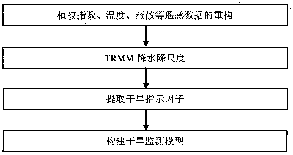
[0048] Example: Using the MODIS data of Guizhou Province in 2002-2012 as the data source, the drought situation in Guizhou in 2009-2010 was dynamically monitored. Such as figure 1 As shown, the specific implementation steps are:

[0049] Step 1. Data reconstruction of MODIS vegetation index products, land surface temperature products, and evapotranspiration products from 2002 to 2012. The low-quality data of MODIS MOD13 products are filled with the average vegetation index of other years in the same month. The time series vegetation index is denoised and smoothed using Hants filtering technique. For the MOD11A2 surface temperature product, the synthesis algorithm takes the proportion of days occupied by the 8d surface temperature product of each scene in a certain month as the weight, and then linearly adds all the surface temperature products of the day and month according to the weight. For some invalid value areas in the synthetic data, the average value algorithm is use...


PUM


Abstract

The invention discloses a drought monitoring method based on data mining. The steps of the method are as follows: step 1, data reconstruction is performed on MODIS vegetation index products, surface temperature products, and evapotranspiration products; step 2, according to the vegetation index obtained in step 1 and DEM data, downscale TRMM precipitation products; step 3, extract vegetation anomaly index, temperature anomaly index, evapotranspiration anomaly index, precipitation anomaly index; step 4, construct statistical regression rules and linear fitting model with classification regression tree model to get Drought Monitoring Model. Compared with the prior art, the present invention comprehensively considers the multi-source remote sensing spatial information in drought monitoring, including precipitation, evapotranspiration, vegetation growth status, land use type, altitude and other factors, uses spatial data mining to build a drought monitoring model, and improves Accuracy of Drought Monitoring.

Description

technical field [0001] The invention relates to the field of environmental monitoring, in particular to a drought monitoring method based on data mining. Background technique [0002] Traditional drought monitoring is limited to using soil water content data distributed on relatively sparse points on the ground to monitor drought conditions and distribution range. Due to the small amount of ground monitoring data and poor representation, dynamic monitoring of large-scale drought disasters cannot be realized. Satellite remote sensing information provides an efficient and convenient technical platform for large-scale drought disaster monitoring because of its macroscopic, dynamic, objective, and time-sensitive characteristics. [0003] Remote sensing technology is a necessary means to obtain distributed information on the land surface. Since remote sensing technology turned to civilian use, using remote sensing technology to monitor regional drought has become one of the mai...

Claims


Application Information

Patent Timeline
Patent Type & Authority Patents(China)
IPC IPC(8): G06K9/00G06K9/62
CPCG06V20/188G06F18/24147
Inventor 冯杰何祺胜杨志勇于赢东王兴勇刘盈斐王开王鹏吕烨张良艳翁白莎邵薇薇
Owner CHINA INST OF WATER RESOURCES & HYDROPOWER RES
Why Eureka
Try Eureka