Real time high accuracy geospatial database for onboard intelligent vehicle applications

a real-time, high-accuracy technology, applied in the field of real-time accessible geospatial database, can solve the problems of insufficient resolution, accuracy or access times for intelligent vehicle applications developed for real-time driver assistant technologies, and limited to the simple information of conventional digital maps

Inactive Publication Date: 2005-07-07
MINNESOTA UNIV OF
View PDF66 Cites 253 Cited by
  • Summary
  • Abstract
  • Description
  • Claims
  • Application Information

AI Technical Summary

Benefits of technology

[0013] The present invention is directed to a geospatial database management system that manages geospatial data relating to a vehicle travel path having one or more lanes. The geospatial database management system includes a geospatial database containing data elements that identify locations of a plurality of road features of a tangible road. The road features are displaced from each other in a widthwise direction that is transverse to the road.

Problems solved by technology

However, they are limited to the simple road map information in conventional digital maps, augmented with a small amount of additional information.
Existing digital road network databases, although becoming more prevalent, simply do not have adequate resolution, accuracy or access times for intelligent vehicle applications developed for real time driver assistant technologies.

Method used


Image

  • Real time high accuracy geospatial database for onboard intelligent vehicle applications
  • Real time high accuracy geospatial database for onboard intelligent vehicle applications
  • Real time high accuracy geospatial database for onboard intelligent vehicle applications

Examples


Embodiment Construction

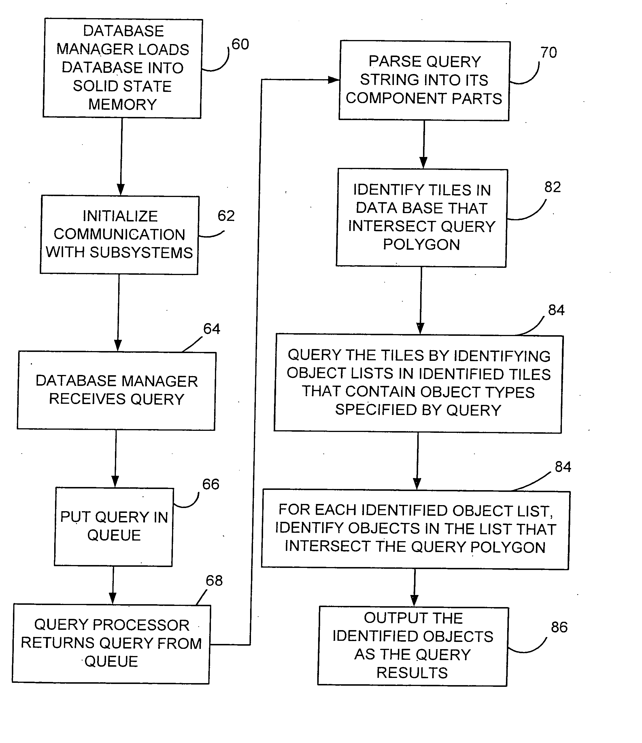
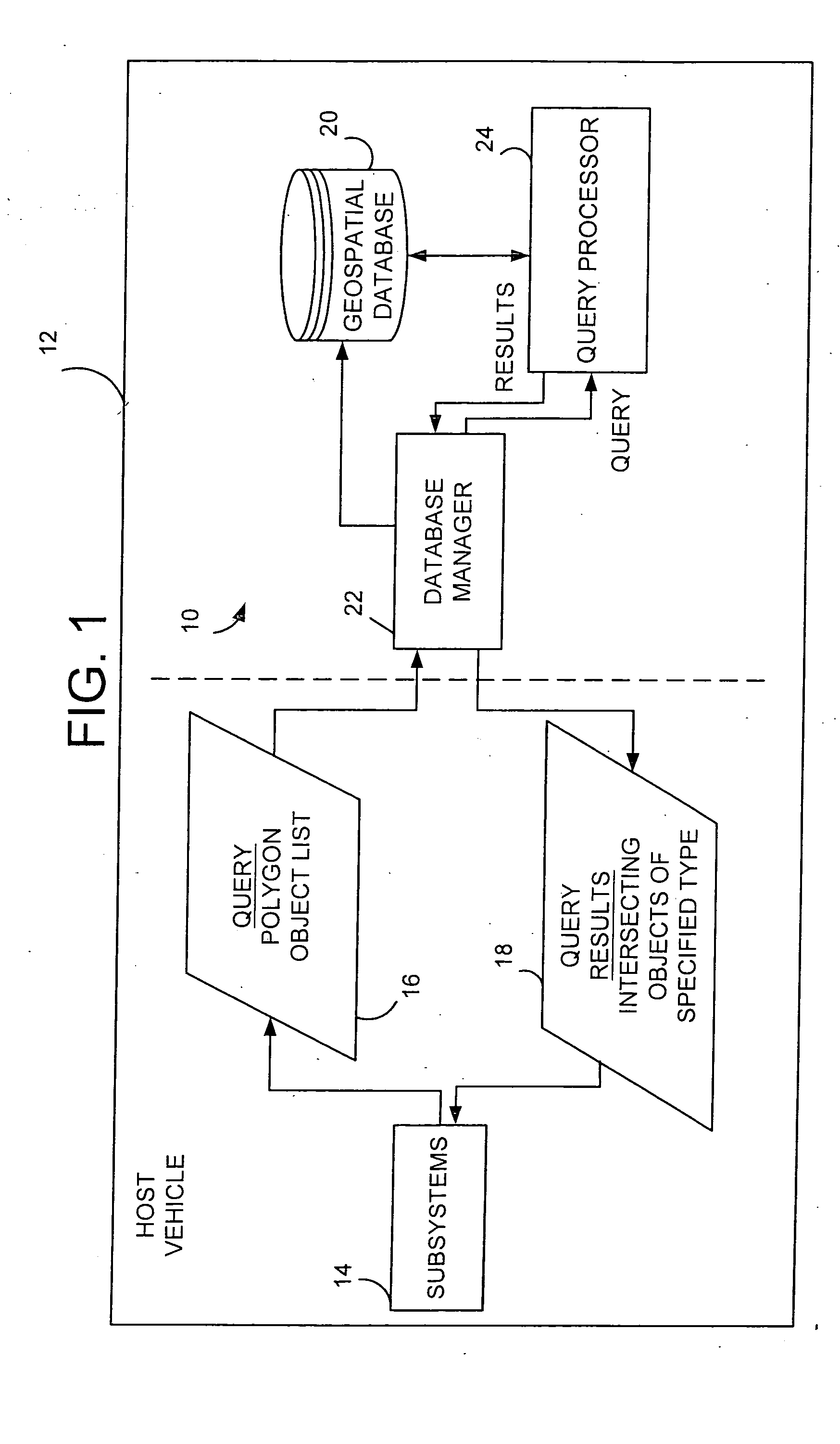
[0028]FIG. 1 is a block diagram of a geospatial database management system 10 to be used on a host vehicle 12 with one or more onboard intelligent subsystems 14 (such as driver assist subsystems). Subsystems 14 illustratively assist the driver of vehicle 12 in a variety of different ways. By way of example, subsystems 14 may provide an operator interface which conveys information to the operator indicative of the position of vehicle 12 within a lane of traffic, and also indicate to the driver information about objects around the vehicle.

[0029] In order to convey that information to the user, subsystems 14 provide a query 16 to database management system 10 and receive query results 18. The query results can indicate the location of a wide variety of objects relative to vehicle 12.

[0030] While the present invention does not depend on the particular type of subsystem 14 being used, a number of those subsystems will now be described in a bit greater detail to enhance understanding of...


PUM


Abstract

A geospatial database management system includes a geospatial database containing data elements that identify locations of a plurality of road features of a tangible road. The road features are displaced from each other in a widthwise direction that is transverse to the road.

Description

[0001] The present application is a continuation of U.S. patent application Ser. No. 10 / 091,182, filed Mar. 5, 2002, which in turn is based on and claims the benefit of U.S. provisional patent application Ser. No. 60 / 273,419, filed Mar. 5, 2001; and the present application is also a continuation-in-part of U.S. patent application Ser. No. 09 / 618,613, filed Jul. 18, 2000, and entitled MOBILITY ASSIST DEVICE. The contents of all of the above-referenced applications are hereby incorporated by reference in their entirety.BACKGROUND OF THE INVENTION [0002] The present invention relates to a driver assist system. More specifically, the present invention relates to a real time accessible geospatial database that can be used with driver assist subsystems. [0003] Geographic information systems (GIS) are systems that are used to store and manipulate geographic data. GIS is primarily used for collection, analysis, and presentation of information describing the physical and logical properties o...

Claims


Application Information

Patent Timeline
Patent Type & Authority Applications(United States)
IPC IPC(8): G01C21/26
CPCG01C21/26B60T2201/082B60T2201/08G06F16/29G01C21/32B60W2556/50
Inventor DONATH, MAXNEWSTROM, BRYANSHANKWITZ, CRAIG R.GORJESTANI, ALECLIM, HEONMINALEXANDER, LEE
Owner MINNESOTA UNIV OF
Why Eureka
Try Eureka