Geocoding locations near a specified city

a geocoding and location technology, applied in the field of digital mapping, can solve the problems of inconvenient geocoding, inability to specify the the end user is not sure what city an address or intersection is located,

Active Publication Date: 2005-08-04
UBER TECH INC
View PDF26 Cites 20 Cited by
  • Summary
  • Abstract
  • Description
  • Claims
  • Application Information

AI Technical Summary

Benefits of technology

[0013] In one embodiment, a geographic object to be located is identified by, for example, a street name, street number and city. A user (or automated process) additionally specifies a buffer distance relative to an uncertain portion of the geographic object identification-for example, if the user is uncertain of the city in which the geographic object is actually located, the user may specify a buffer distance from the city, e.g., 5 miles, which should also be searched to locate the object. In this embodiment, the present invention then finds a set of keys asso...

Problems solved by technology

A major inconvenience in geocoding is that often end users are not sure what city an address or intersection is in.
In such cases conventional geocoding software can fail: If the intersection of Grant and Pine is in Mayfield, then geocoding “Grant ...

Method used


Image

  • Geocoding locations near a specified city
  • Geocoding locations near a specified city
  • Geocoding locations near a specified city

Examples


Embodiment Construction

System Architecture

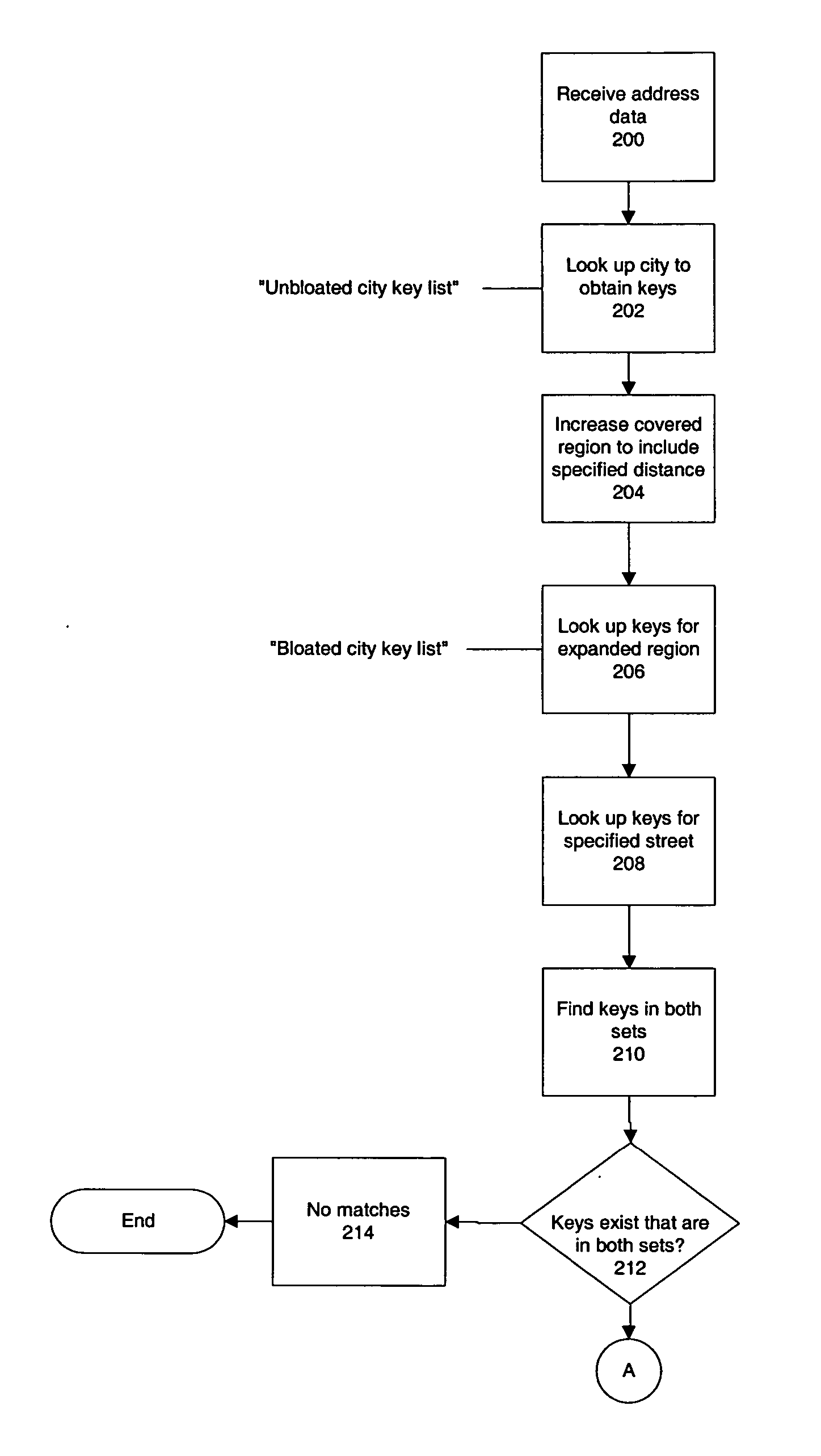
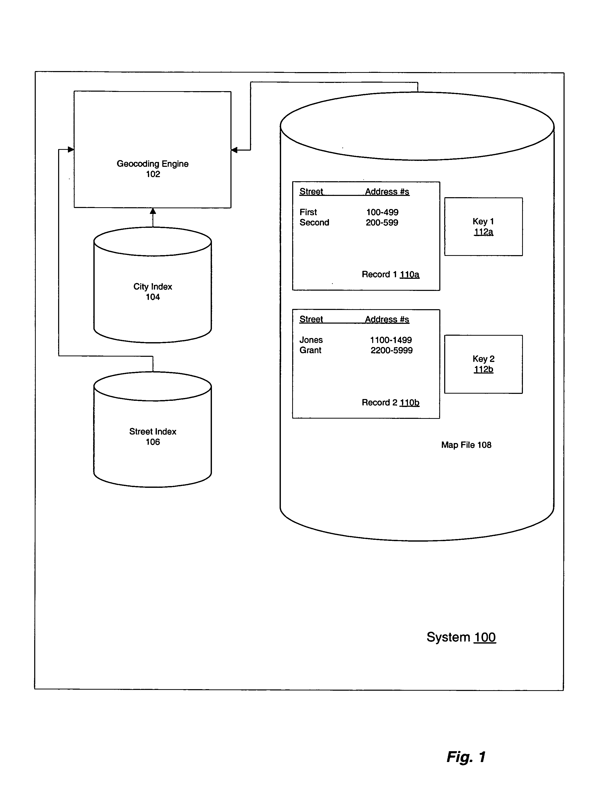
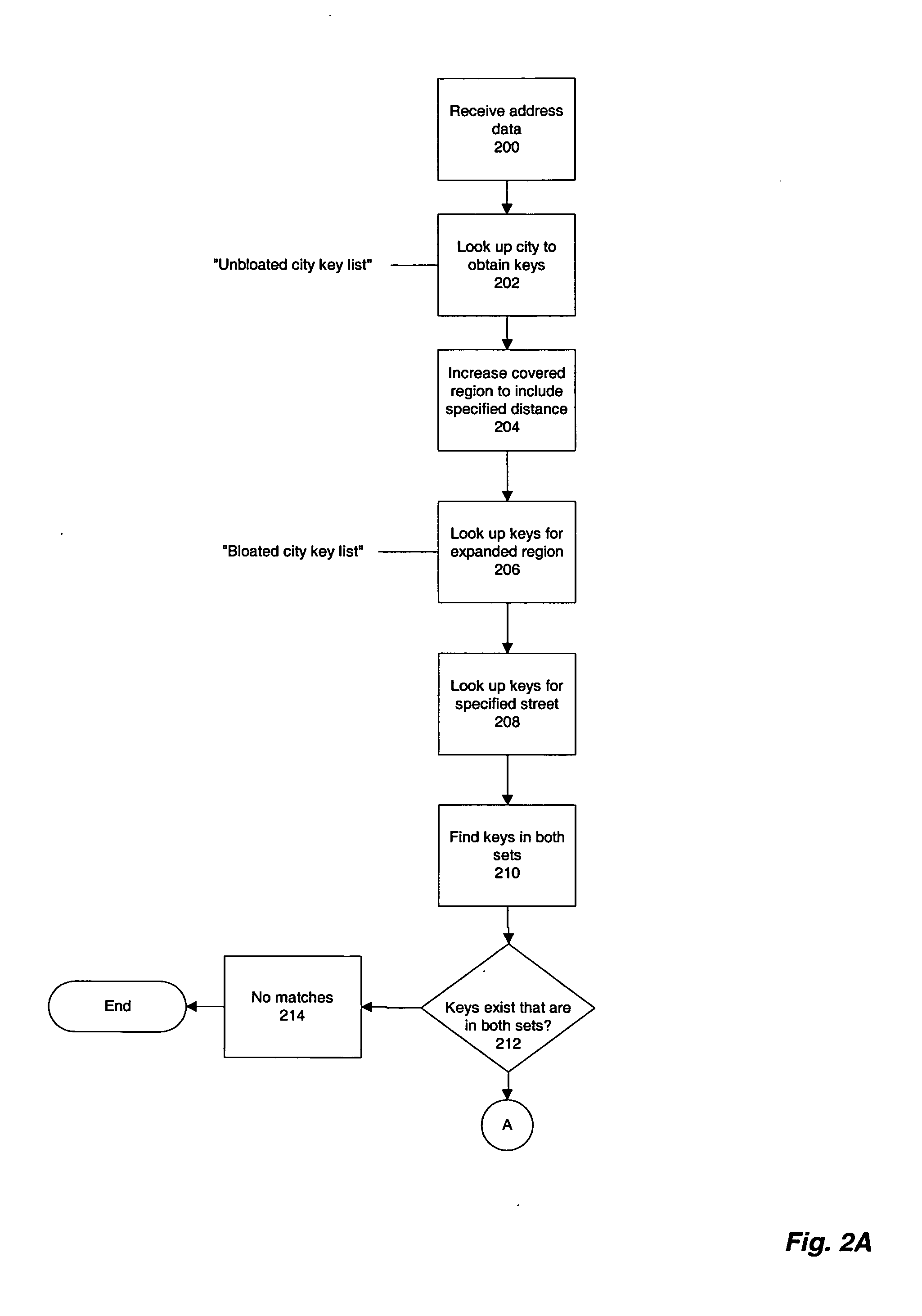
[0017]FIG. 1 illustrates a system 100 for performing nearby geocoding in accordance with an embodiment of the present invention. System 100 includes a geocoding engine 102, a city index 104, a street index 106, and a map file 108. Each of these components of system 100 is described further below.

[0018] In a preferred embodiment, map data is constructed prior to use of system 100 for providing nearby geocoding. Constructing map data preferably includes building three files: the map file 108 and two index files, the city index file 104 and the street index file 106.

[0019] Data in the map file 108—in particular, data regarding the locations and address numbers of streets—is preferably divided into records 110a, 110b, etc. of geographically contiguous data. Lookup keys 112a, 112b, etc. are assigned to these records 110a, 110b, etc., as a function of their geographical location, one key per record. Keys preferably correspond to geographic regions, map data for whic...


PUM


Abstract

Specified streets or intersections that are within a specified distance of a specified city can be found by a search, even when they are not actually in that city. For computational efficiency, some addresses are included in search results even when they exceed the specified distance from the specified city by a small amount (“false positives”). The search method guarantees that no instance of the street name within the specified distance of the specified city is erroneously missed (“false negatives”).

Description

CROSS-REFERENCE TO RELATED APPLICATIONS [0001] This application claims the benefit of U.S. Provisional Application No. 60 / 530,935, filed on Dec. 19, 2003, which is incorporated by reference herein in its entirety.BACKGROUND OF THE INVENTION [0002] 1. Field of the Invention [0003] The present invention relates generally to digital mapping. More specifically, the present invention is related to geocoding operations designed to locate geographic objects where there is uncertainty about a portion of an object identifier such as a city in which the object is located. [0004] 2. Description of the Related Art [0005] Many modern computing systems use digital maps to allow users to orient themselves, to find the locations of desired addresses, intersections, or businesses, to be directed to those locations, and for many other purposes. For example, maps and driving directions are available from many sites on the World Wide Web; many companies make maps of, and directions to, their office loc...

Claims


Application Information

Patent Timeline
IPC IPC(8): G01C21/30G01C21/34
CPCG06F17/30241G01C21/3605G06F16/29G06F16/2468G06F16/248
Inventor SMARTT, BRIAN E.POPPEN, RICHARD F.DUNN, LINNEA A.
Owner UBER TECH INC
Why Eureka
Try Eureka