Auto mapping through location based triggers

a technology of location based triggers and auto mapping, applied in the direction of navigation instruments, process and machine control, instruments, etc., can solve the problems of unmapped area, company or dispatcher not being able to alert workers, and requiring near real-time provision of current mapping information, etc., to achieve the effect of increasing the granularity of detail

Inactive Publication Date: 2007-06-07
DISCRETE WIRELESS
View PDF15 Cites 83 Cited by
  • Summary
  • Abstract
  • Description
  • Claims
  • Application Information

AI Technical Summary

Benefits of technology

[0009] In one embodiment, the present invention includes a system for updating and creating mapping information for an active mapping region. The system includes two primary components: a control system and one or more mobile devices. Each of the mobile devices includes a GPS receiver and a radio transceiver. The mobile devices communicate with the control system through the radio transceiver. In operation, the mobile devices periodically obtain a current location reading from the GPS receiver and then transmit the current location reading to the control system. The control system receives the current location reading from a mobile device and determines if the current location reading falls within an active mapping zone. If the current location reading is within in active mapping zone, the control system begins updating the mapping information using the last reading and subsequent location readings from the mobile device. In addition, the control system may request the mobile device to increase the frequency at which the location readings are provided. This aspect of the invention increases the granularity of detail in the mapping information. Once the location reading falls outside of the active mapping region, the control system requests the mobile device to revert to normal reporting mode and commences with normal operation.

Problems solved by technology

However, there are industries that not only require up-to-date mapping information, but actually demand near real-time provision of current mapping information.
If information pertaining to entries in a particular person's work order changed, the company or dispatcher would not be able to alert the worker unless the worker called in during the day or, if the company was able to track the worker down by calling the various locations that the worker should be visiting in accordance with his or her work orders.
However, operating within an unmapped area, such as a new construction territory, in which roads, addresses and other mapping information is not available can be problematic.
Tracking deployed work forces in such an environment can prove to be exceedingly problematic.

Method used


Image

  • Auto mapping through location based triggers
  • Auto mapping through location based triggers
  • Auto mapping through location based triggers

Examples


Embodiment Construction

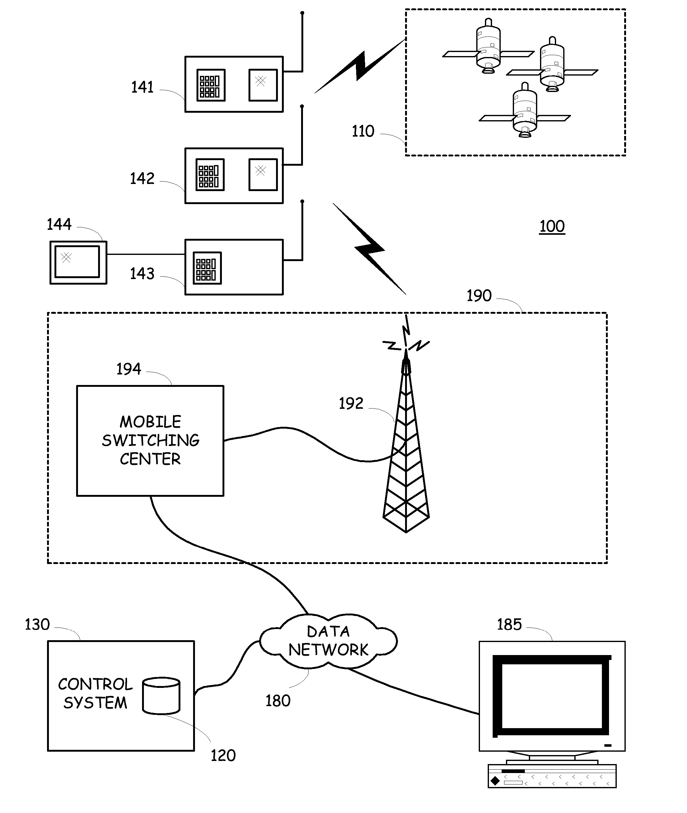
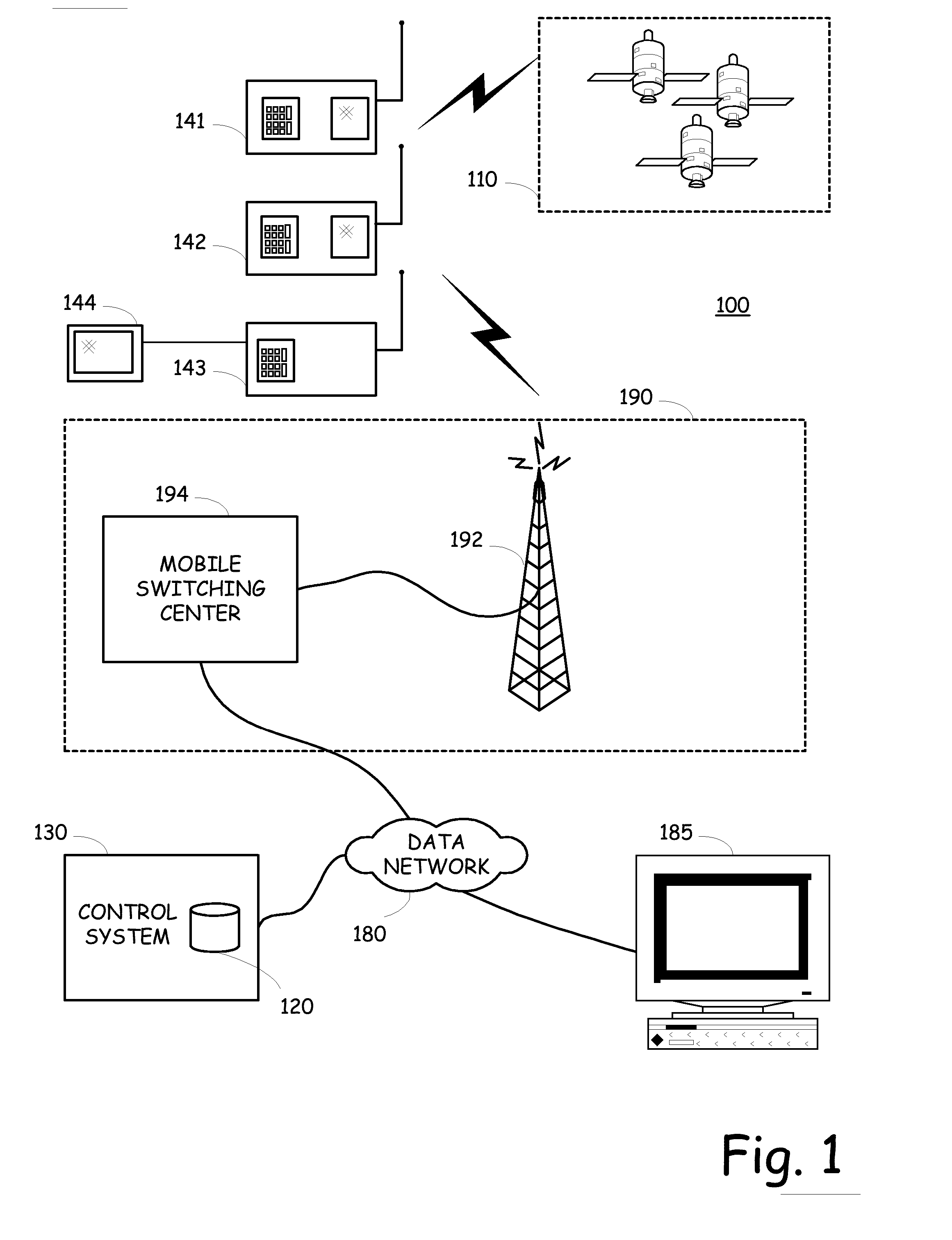
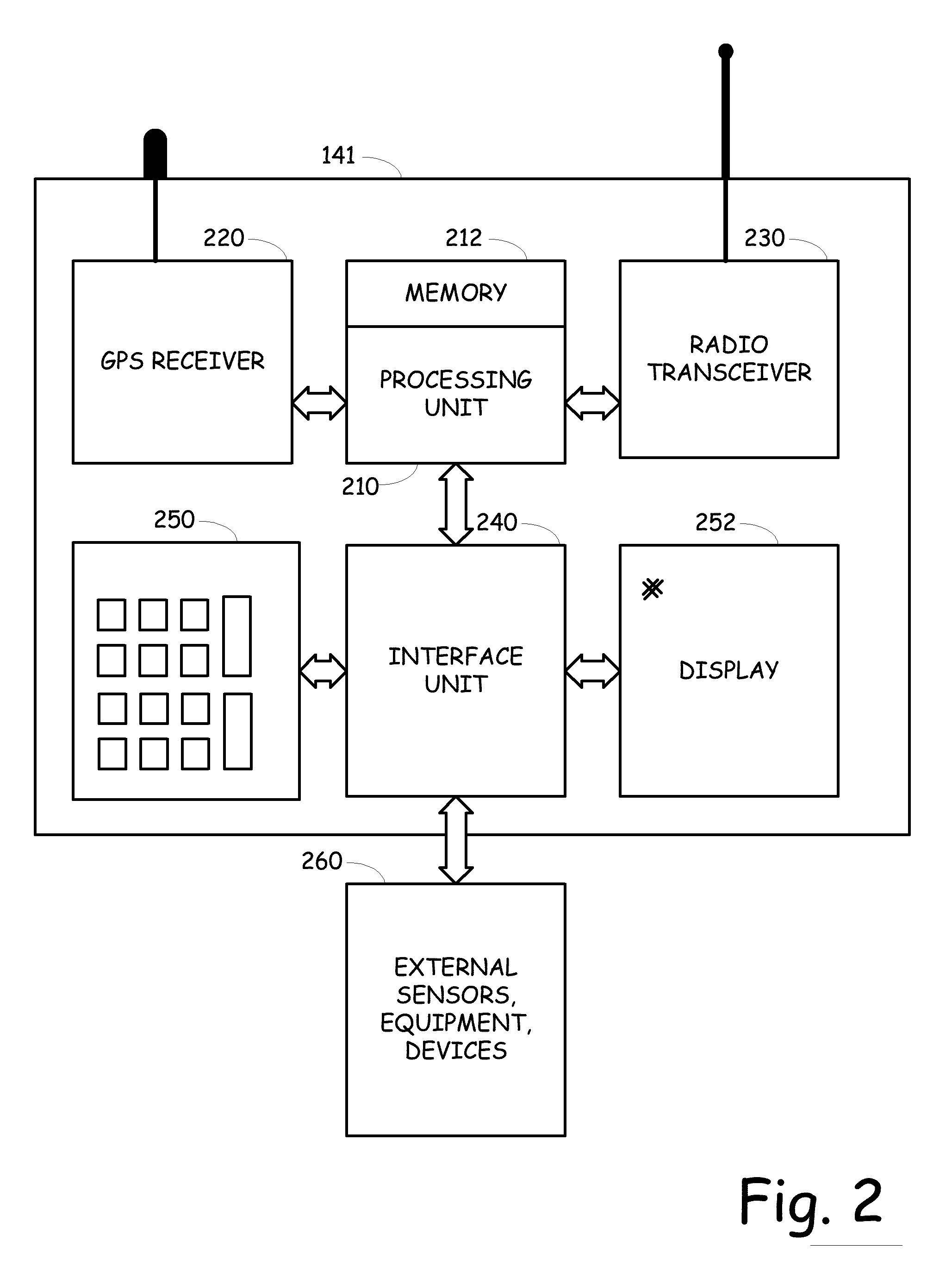
[0023] The present invention, among other things, operates to create updated mapping information for new construction areas, but can also be employed in creating mapping information for any uncharted area, as well as simply verifying, augmenting or updating mapping information for any area. More specifically, in one embodiment of the present invention, work forces that are deployed within an area to be mapped are equipped with location identification equipment, such as a GPS receiver, and optionally, with wireless data communication equipment. Thus, as a work force moves into an area to be mapped, the entrance into the unmapped region can be detected, and as the work force member travels within the area, new mapping information can be obtained, stored, and used in the future by other work force entities entering into that area.

[0024] Although for illustrative purposes, the present invention is described within particular embodiments or applications, it should be appreciated that th...


PUM


Abstract

An automated map generator that can be used for creating new maps for uncharted areas, augmenting uncompleted maps, or creating maps for areas that are changing dynamically. One or more mobile devices include location based technology that operates to identify a current location for the mobile device and report that location to the map creation application. If the location of the mobile device is within an active mapping region, the map creation device can instruct the mobile device to report its location on a more frequent basis and then commence to map out the route to the mobile device. As the route is mapped out, a new map of the territory is created. As subsequent devices enter into that area (including navigational systems), the updated mapping information is provided to the device and can then be augmented by future location readings or can simply be used by the device.

Description

CROSS-REFERENCE TO RELATED APPLICATIONS [0001] The present invention is related to, and incorporates herein by reference, U.S. patent application entitled GEO-FENCE LOCATION-SPECIFIC EQUIPMENT STATUS BASED TRIGGER DIRECTED CONTENT DELIVERY, filed on the same day as the present application and having attorney docket number 04003.1020 and assigned Ser. No. 11 / 164,679. BACKGROUND OF THE INVENTION [0002] This invention is related to the fields of geocentric location devices and systems, and distributed geocentric location based systems and their application to cartography and, more particularly to utilizing geocentric location based systems to map out un-charted or modified topographies and utilizing the created mappings within a navigation system. [0003] The earliest direct evidence of the creation of maps is a Babylonian clay tablet which shows the earth as a flat, circular disk. It is estimated that this tablet was created around 1000 B.C. Thus, we can safely say that for at least 30...

Claims


Application Information

Patent Timeline
Patent Type & Authority Applications(United States)
IPC IPC(8): H04Q7/20H04W60/02
CPCG01C21/30G01S5/0027G01S19/14H04W60/02
Inventor THACHER, JEFFERY W.
Owner DISCRETE WIRELESS
Why Eureka
Try Eureka