Method and System of Generating 3D Images with Airborne Oblique/Vertical Imagery, GPS/IMU Data, and LIDAR Elevation Data

a technology of 3d images and airborne oblique/vertical images, applied in the direction of distance measurement, instruments, and using reradiation, etc., can solve the problems of unmeasurable buildings, other ground objects such as trees, and unrealistic appearance of other ground objects

Active Publication Date: 2007-11-22
HUAZHENG GEOSPACE
View PDF4 Cites 52 Cited by
  • Summary
  • Abstract
  • Description
  • Claims
  • Application Information

AI Technical Summary

Problems solved by technology

Although the 3D building models created in this way normally look good, most of them are not geo-referenced in the real world coordinate system, i.e., they are not measurable.
Further, the buildings that were not collected for various reasons (such as cost) and other ground objects, such as trees will look unreal and bad.
In general, 3D ground surface models created in such way only look good at those buildings that were captured and look bad for those not captured.
Additionally, the entire process to produce such a 3D ground surface model is very time consuming and labor intensive, particularly for the making of building facets, which so far limits its use only to a limited number of big cities.
Conventionally, the determination of exterior orientation of airborne imagery, oblique or vertical imagery, is made through an aerial triangulation process, which would need ground control points and is very difficult to obtain accurate and reliable result for oblique imagery because of its oblique nature.
The ground surface elevation or range data collected by a LIDAR system cannot be easily, if can at all, matched by the today's conventional photogrammetric processes.
Although on a 2D orthophoto, one can make many measurements, all the measurements are limited to 2D, i.e., only in XY plane, no third dimensional information available.

Method used


Image

  • Method and System of Generating 3D Images with Airborne Oblique/Vertical Imagery, GPS/IMU Data, and LIDAR Elevation Data
  • Method and System of Generating 3D Images with Airborne Oblique/Vertical Imagery, GPS/IMU Data, and LIDAR Elevation Data
  • Method and System of Generating 3D Images with Airborne Oblique/Vertical Imagery, GPS/IMU Data, and LIDAR Elevation Data

Examples


Embodiment Construction

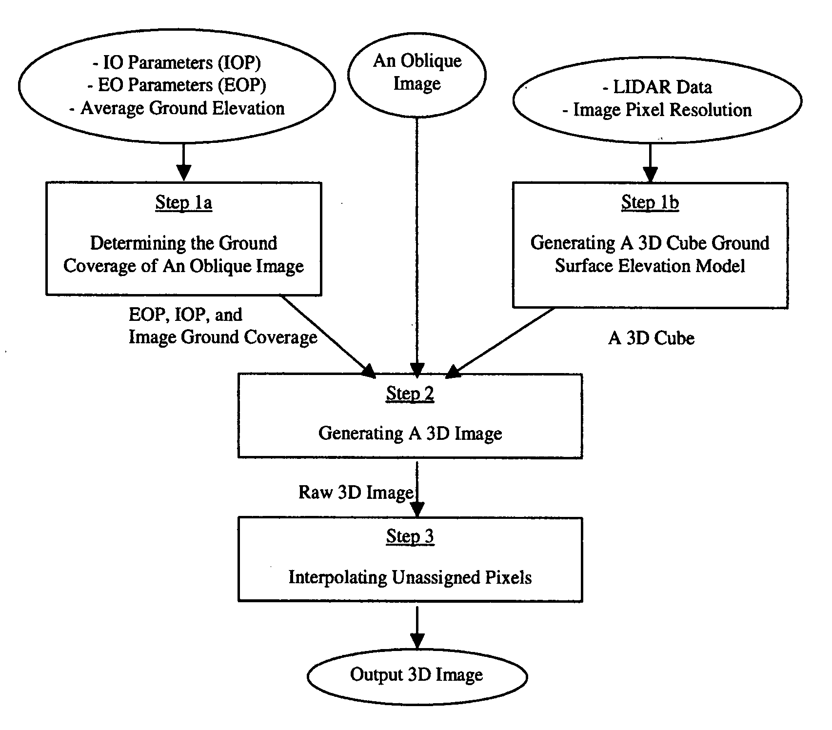
[0023]A 3D Image of ground surface of this invention is an image that has three-dimensional XYZ coordinates for every pixel of the image in a ground coordinate system. The scene covered and represented by such a 3D Image is a three-dimensional real world scene where every visible thing in the 3D Image has 3D coordinates. The three-dimensional XYZ coordinates of the pixels of a 3D Image are attributed by the method and system of this invention that generates 3D Images with airborne oblique / vertical imagery, GPS / IMU, and LIDAR ground surface elevation or range data.

[0024]The generation of a 3D Image uses airborne oblique and / or vertical imagery for the pictures of the ground surface, GPS / IMU data for the input imagery geo-referencing that puts the imagery in a ground coordinate system, and LIDAR data for ground surface elevations or ranges. The geo-referencing for the imagery and the LIDAR data have to be in a same ground coordinate system. The method and system of this invention can ...


PUM


Abstract

This invention relates to a three-dimensional image of ground surface and the method and system that generates the three-dimensional image. Here, a three-dimensional image is an image that has three-dimensional XYZ coordinates in a ground coordinate system for every pixel of the image and the ground surface means the bare-earth surface plus all the objects on the bare-earth surface. The scene covered and represented by such a three-dimensional image is a three-dimensional real world scene where everything visible in the three-dimensional image has three-dimensional coordinates. The three-dimensional XYZ coordinates of all the pixels of a three-dimensional image are attributed by the method and system of this invention for generating three-dimensional images with airborne oblique/vertical imagery, GPS/IMU, and LIDAR ground surface elevation or range data. On such a three-dimensional image, one can make direct measurements of location, length, distance, height, area, and volume and indirect measurements including but not limited to profile and sight of view all in the real world three-dimensional coordinate system. Additionally, application systems that utilize three-dimensional images can make three-dimensional displays or perspective views of the ground surface with fly-through or walk-through, rotations and zoom in and out, and three-dimensional manipulation and simulation of ground surface.

Description

FIELDS OF THE INVENTION[0001]This invention relates to the generation of a geo-referenced three-dimensional image (3D Image) of the ground surface, where ground surface means the bare-earth surface plus all the objects on the bare-earth surface and geo-referenced means measurable in a real world coordinate system for location, distance, height, area, volume, and direction for the ground surface. In terms of technology and science, the invention is in the fields of photogrammetry, remote sensing, and 3D ground surface modeling.BACKGROUND OF THE INVENTION[0002]Being able to see and sometimes to measure a real world scene in 3D on a computer is a natural desire of human being and also the need in many applications. The purpose of making 3D Images is to provide an effective and efficient foundation data and representation to the building of a geo-referenced 3D ground surface model (GR3DGSM). Such a GR3DGSM allows the viewing and measuring of the ground surface of the real world from aer...

Claims


Application Information

Patent Timeline
Patent Type & Authority Applications(United States)
IPC IPC(8): G06K9/00G06F17/00
CPCG01C11/00G06T17/05G01S17/89G01S17/023G01S17/86
Inventor WANG, ZHENG
Owner HUAZHENG GEOSPACE
Why Eureka
Try Eureka