Navigation device, navigation method, and vehicle

a navigation device and navigation method technology, applied in navigation instruments, traffic control systems, instruments, etc., can solve problems such as different views and cg data, and achieve the effects of convenient driving, convenient viewing for users, and convenient understanding of junction sta

Inactive Publication Date: 2009-05-21
PANASONIC CORP
View PDF1 Cites 28 Cited by
  • Summary
  • Abstract
  • Description
  • Claims
  • Application Information

AI Technical Summary

Benefits of technology

[0029]According to the above first aspect, an image of the junction can be displayed with a size (a display magnification), with which it is easy for the user to see the image, according to the distance between the junction and the vehicle. Thus, an image of the vicinity of the junction, which is required for the user, is displayed in a form which provides easy understanding, thereby enabling the user to drive safely.
[0030]According to the second aspect, since a part of the taken image is enlarged and displayed, an image which facilitates understanding of a state of the junction can be offered to the user.
[0031]According to the third aspect, during a period when the vehicle approaches the junction, an image of the junction with the substantially same area can be offered. Thus, an image of the junction which constantly provides easy understanding can be offered.
[0032]According to the fourth and fifth aspects, when the vehicle approaches close to the junction, an image in the branch direction can be shown in advance to the user to draw the user's attention. Thus, the user can drive with attention paid to road state, and the like after right turn or left turn.
[0033]According to the sixth aspect, an image with an appropriate size according to the road width at the junction can be offered. Thus, an image which facilitates user's understanding of a state of the junction can be offered.
[0034]According to the seventh aspect, since an image of the junction is zoomed and taken, a clear image of the junction can be offered. This makes it easier for user to understand a state of the junction.

Problems solved by technology

However, the CG data is different from a view which is viewed by the driver in various points, for example, a vehicle present ahead of the own vehicle and a facility newly built are actually not drawn.

Method used


Image

  • Navigation device, navigation method, and vehicle
  • Navigation device, navigation method, and vehicle
  • Navigation device, navigation method, and vehicle

Examples


first embodiment

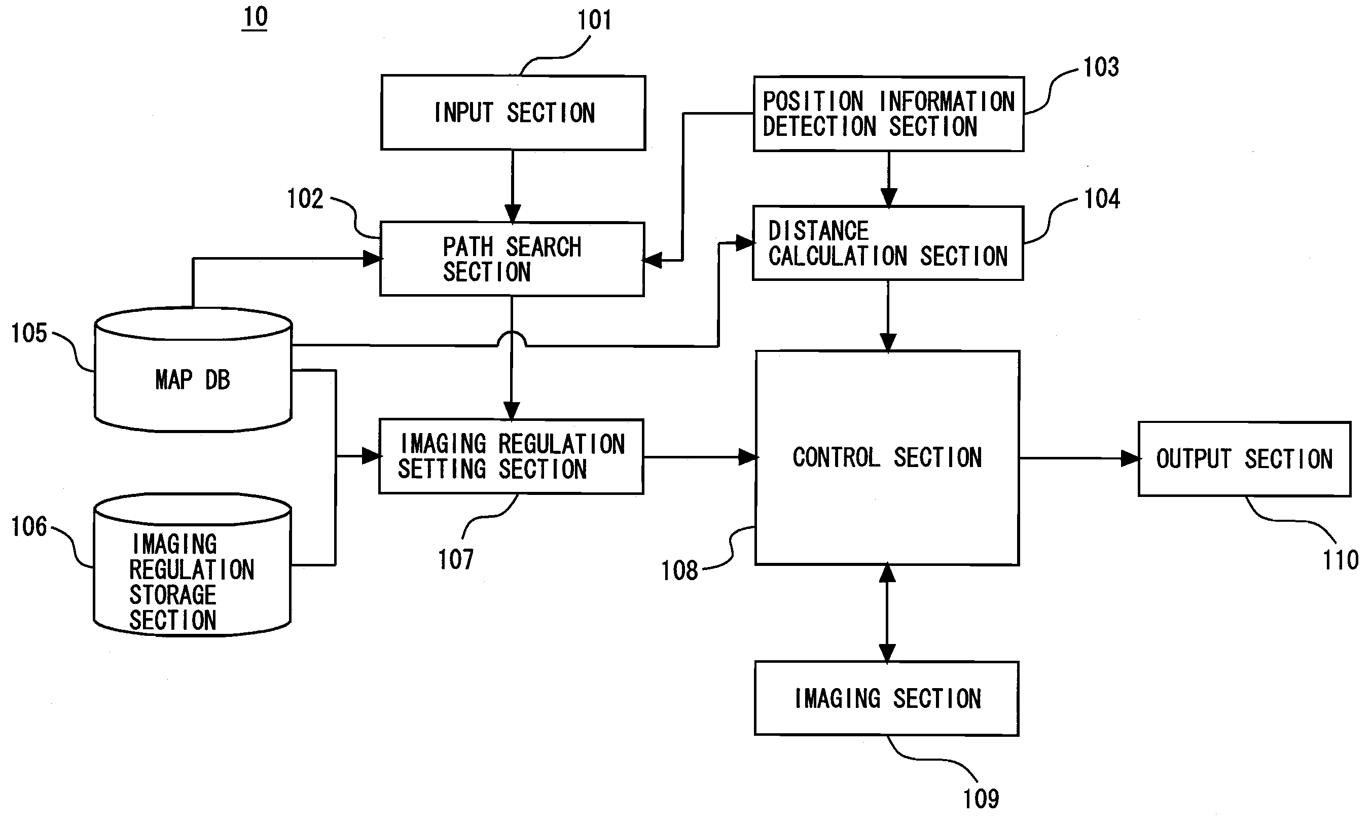
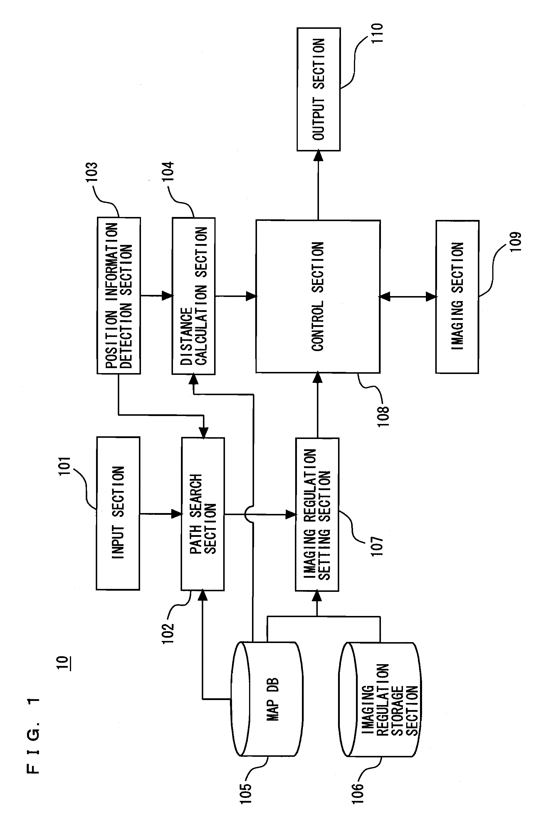
[0074]FIG. 1 is a block diagram of a navigation device (hereinafter, referred to as a navi device) according to a first embodiment of the present invention. As shown in FIG. 1, the navi device 10 includes an input section 101, a route search section 102, a position information detection section 103, a distance calculation section 104, a map DB 105, an imaging regulation storage section 106, an imaging regulation setting section 107, a control section 108, an imaging section 109, and a display section 110.

[0075]The input section 101 is means for inputting information concerning a destination to the navi device, and includes a remote control, a touch panel, a microphone for audio input, and the like.

[0076]The route search section 102 refers to the information concerning the destination which is inputted by the input section 101, vehicle position information which is detected by the position information detection section 103, and the map DB 105, and searches for a route leading to the ...

second embodiment

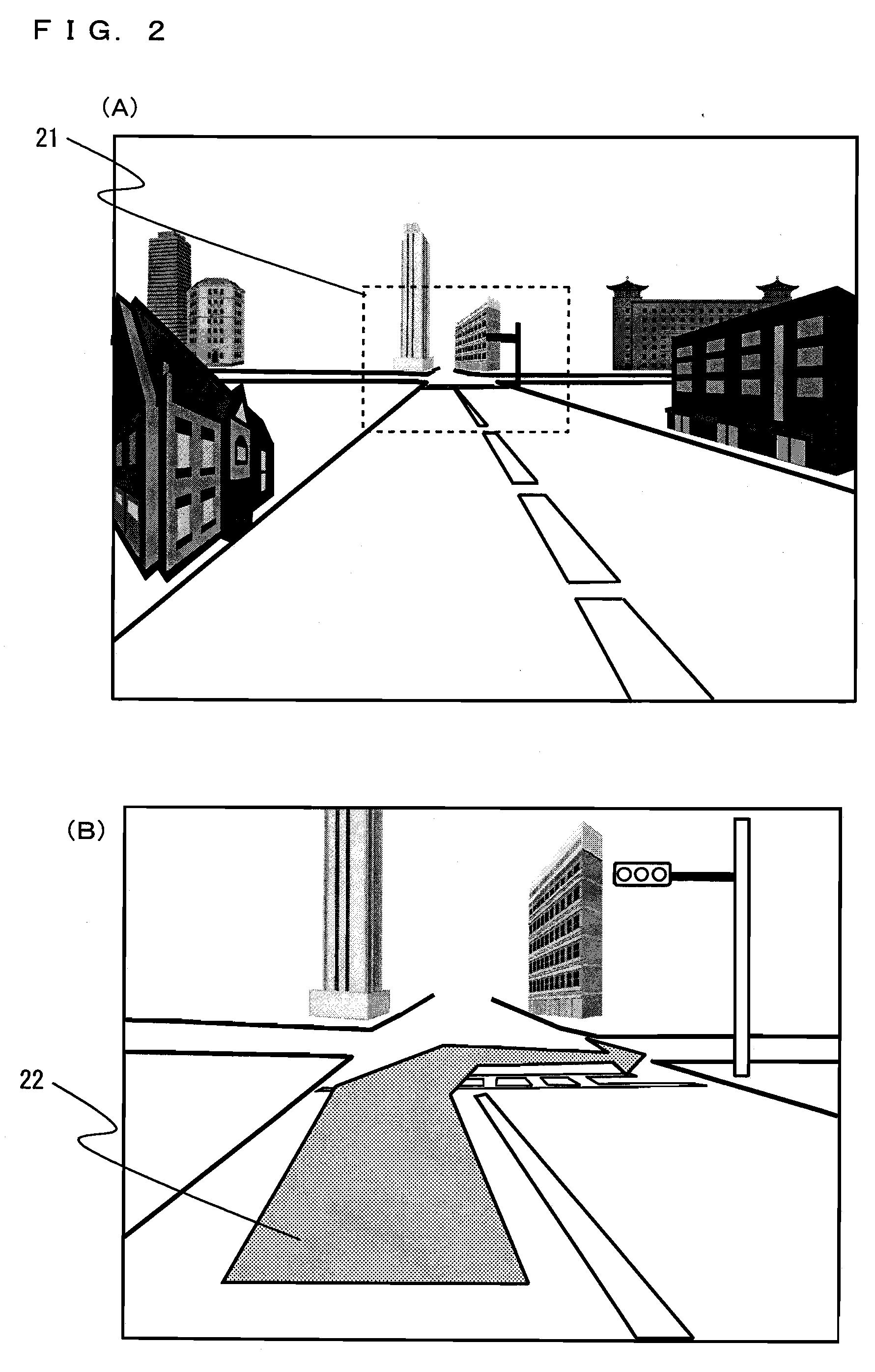
[0111]The following will describe a second embodiment of the present invention with reference to FIGS. 17 to 20. In the above first embodiment, a predetermined region is cut out from the camera image, digitally zoomed, and displayed. On the other hand, in the second embodiment, digital zoom is not used, but optical zoom is used. It is noted that a navi device according to the present embodiment is the same as that according to the above first embodiment except that the imaging section 109 includes first drive means (not shown) for driving a lens for the optical zoom and second drive means (not shown) for changing the facing direction of the imaging section 109, so that the same reference numerals are used and detailed description will be omitted.

[0112]The following will describe data used in the second embodiment. The data used in the present embodiment is basically the same as that in the first embodiment but different from that in the first embodiment in that the each-distance mag...


PUM


Abstract

A navigation device is provided, which at a junction such as an intersection point, and the like, offers to a driver an appropriate image of the vicinity of the junction which is required in turning right or left, and the like.
A route search section (102) searches for a route leading to a set destination. An imaging regulation setting section (107) determines an imaging regulation of an imaging section (109) at a junction which exists on the searched route. A distance calculation section (104) calculates a distance between a position of a vehicle and the junction. A control section (108) changes an image to be shown in an output device according to the calculated distance based on the determined imaging regulation.

Description

TECHNICAL FIELD[0001]The present invention relates to a navigation device, a navigation method, and a vehicle, and more particularly to a navigation device, a navigation method, and a vehicle which show an image taken by an imaging device such as an in-vehicle camera and the like to a driver for assisting travel of the vehicle.BACKGROUND ART[0002]Conventionally, there is widely known a navigation device which is installed in a vehicle, shows a traveling direction to a driver through a display, and performs route navigation. In such a navigation device, map information is stored in advance in an HDD or a DVD (Digital Versatile Disk). The map information includes CG (Computer Graphics) data concerning road information and a junction such as an intersection point, and the like. When the navigation device detects that the vehicle approaches a junction, the navigation device superimposes and draws an arrow indicating a navigation route (a traveling direction) with respect to the CG data ...

Claims


Application Information

Patent Timeline
Patent Type & Authority Applications(United States)
IPC IPC(8): G01C21/36G06T17/05
CPCG01C21/36G09B29/106G08G1/0969G01C21/3647
Inventor KUDOH, TAKAHIROKINDO, TSUYOSHIAKITA, TAKASHI
Owner PANASONIC CORP
Why Eureka
Try Eureka