Video map technology for navigation

a technology of video maps and navigation, applied in the field of navigation, can solve the problems of insufficient information, severe limitations in developing countries, and inability to use digital maps for navigation purposes,

Inactive Publication Date: 2009-10-08
REDDY THIMMANNAGARI CHANDRA +2
View PDF14 Cites 12 Cited by
  • Summary
  • Abstract
  • Description
  • Claims
  • Application Information

AI Technical Summary

Problems solved by technology

Both these technologies may work fine in countries like USA and Canada but have severe limitations in developing countries.
Today digital maps information is not available for most of the developing countries and for the countries for which digital maps information is available, the information is not accurate enough to be able to use for navigation purposes.
Also, many a time, narrow streets are so very close to each other that in most cases the distance between one turn and other turn falls out of GPS tolerance range and usage of GPS in such circumstances may result erroneous navigation.
In countries like India and other developing countries it is quite impossible to navigate using the existing navigation technologies.

Method used


Image

  • Video map technology for navigation
  • Video map technology for navigation
  • Video map technology for navigation

Examples


Embodiment Construction

[0019]The embodiments herein and the various features and advantageous details thereof are explained more fully with reference to the non-limiting embodiments that are illustrated in the accompanying drawings and detailed in the following description. Descriptions of well-known components and processing techniques are omitted so as to not unnecessarily obscure the embodiments herein. The examples used herein are intended merely to facilitate an understanding of ways in which the embodiments herein may be practiced and to further enable those of skill in the art to practice the embodiments herein. Accordingly, the examples should not be construed as limiting the scope of the embodiments herein.

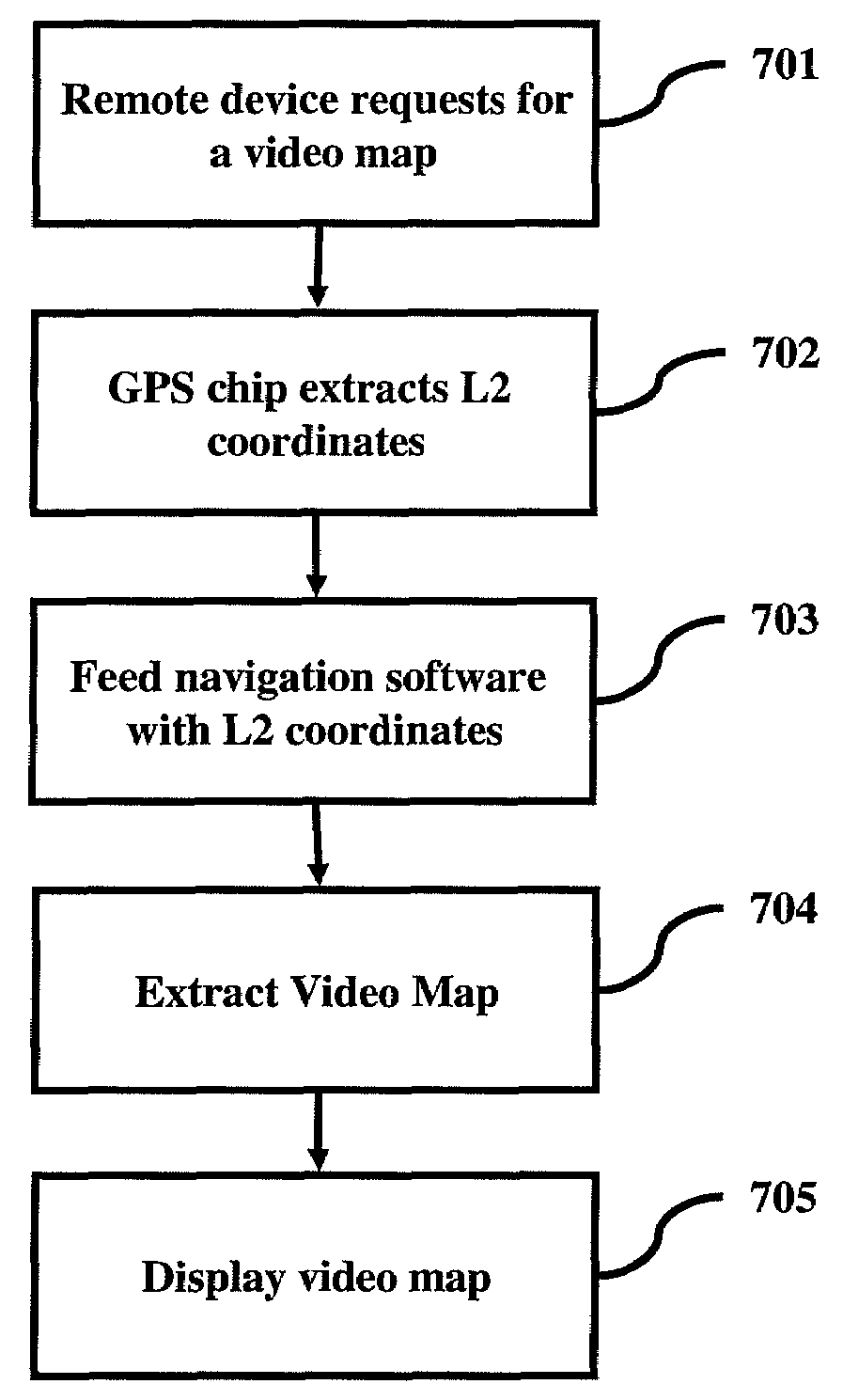
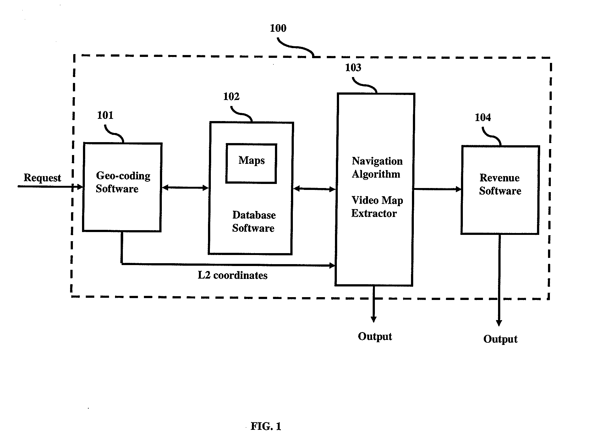
[0020]As mentioned, there remains a need for a navigation technology that is amenable for use in conditions like those prevalent in developing countries. The embodiments herein achieve this by providing a video map based navigation system and methods thereon. Referring now to the drawings, and ...


PUM


Abstract

There remains a need for a navigation technology that is amenable for use in conditions prevalent in developing countries. The embodiments disclosed herein achieve this by providing a video map based navigation system and methods thereon. An embodiment herein provides an electronic navigation system comprising of a means for a user to request for a route between a source and a destination; a means to combine relevant stored video clips based on the source and the destination; a means for sending user requested information to the user; and a means for the user to view information sent by the navigation system.

Description

BACKGROUND[0001]1. Technical Field[0002]The embodiments herein generally relate to navigation, and, more particularly, to using video maps in navigation.[0003]2. Description of the Related Art[0004]Today we have multiple technologies which help in navigation. Existing technologies are largely Internet based and GPS. Internet based navigation systems utilize digital maps to provide turn-by-turn text directions from point A to point B. The navigation information can be printed out and used for navigation. On the other hand GPS based solutions typically provide a navigation device that uses GPS technology. GPS based devices use satellite data to find the latitude and longitude information and map the information onto a pre-loaded digital map to provide directions. Both these technologies may work fine in countries like USA and Canada but have severe limitations in developing countries.[0005]Today digital maps information is not available for most of the developing countries and for the...

Claims


Application Information

Patent Timeline
Patent Type & Authority Applications(United States)
IPC IPC(8): G01C21/00H04N5/93
CPCH04N5/50G01C21/3647
Inventor REDDY, THIMMANNAGARI CHANDRANAVADA, MURALEEDHARARAVI, NARALA
Owner REDDY THIMMANNAGARI CHANDRA
Why Eureka
Try Eureka