Context-sensitive navigational aid

a navigation aid and context-sensitive technology, applied in navigation instruments, surveying and navigation, instruments, etc., can solve the problems of not being valuable in cluttering up a screen with gas stations and restaurants

Active Publication Date: 2009-10-22
INSPIRED POSSIBILITIES LLC
View PDF7 Cites 88 Cited by
  • Summary
  • Abstract
  • Description
  • Claims
  • Application Information

AI Technical Summary

Problems solved by technology

However, cluttering up a screen with gas stations is not valuable when that vehicle's gas tank is mostly full.
Moreover, cl

Method used


Image

  • Context-sensitive navigational aid
  • Context-sensitive navigational aid
  • Context-sensitive navigational aid

Examples


Embodiment Construction

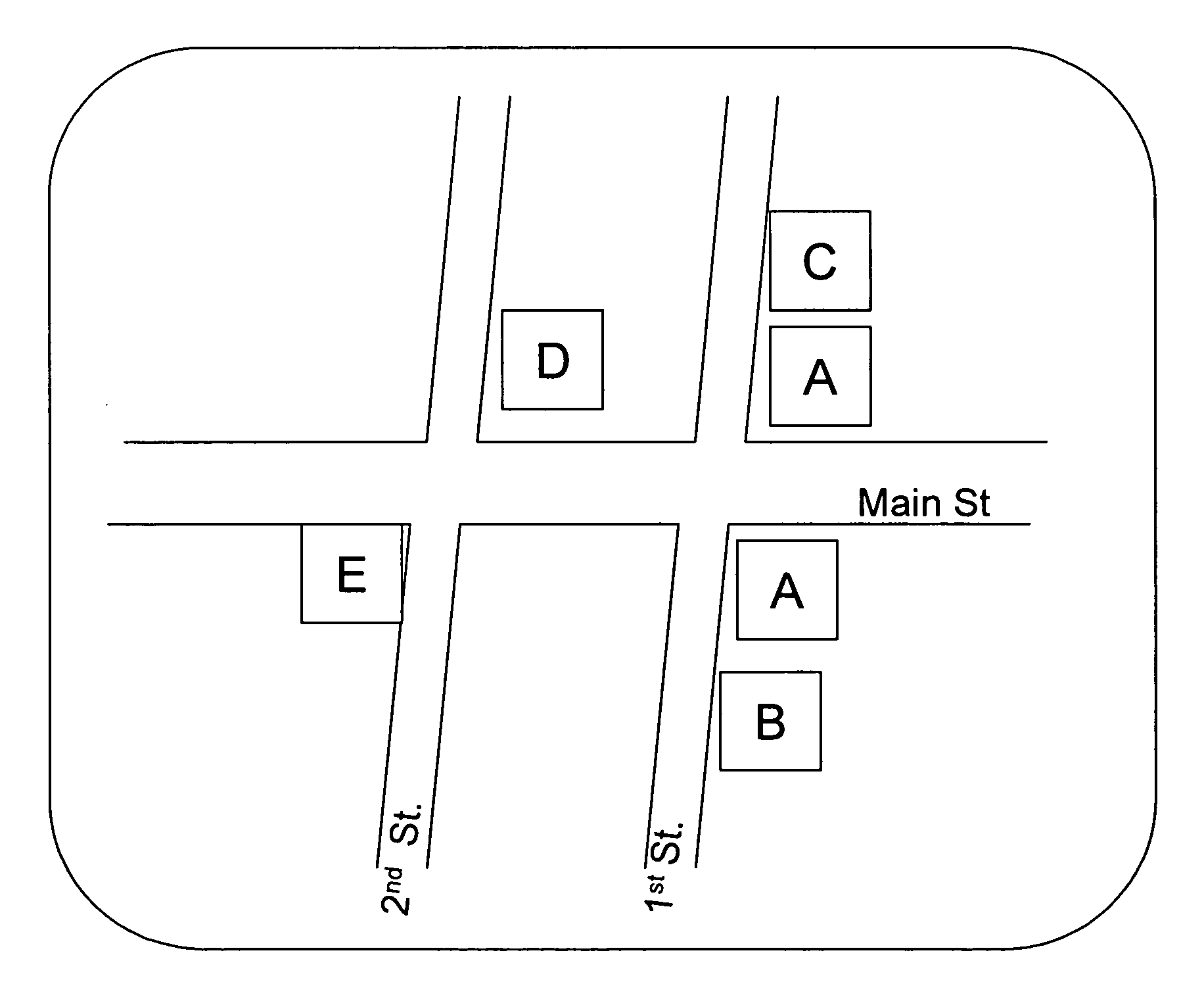
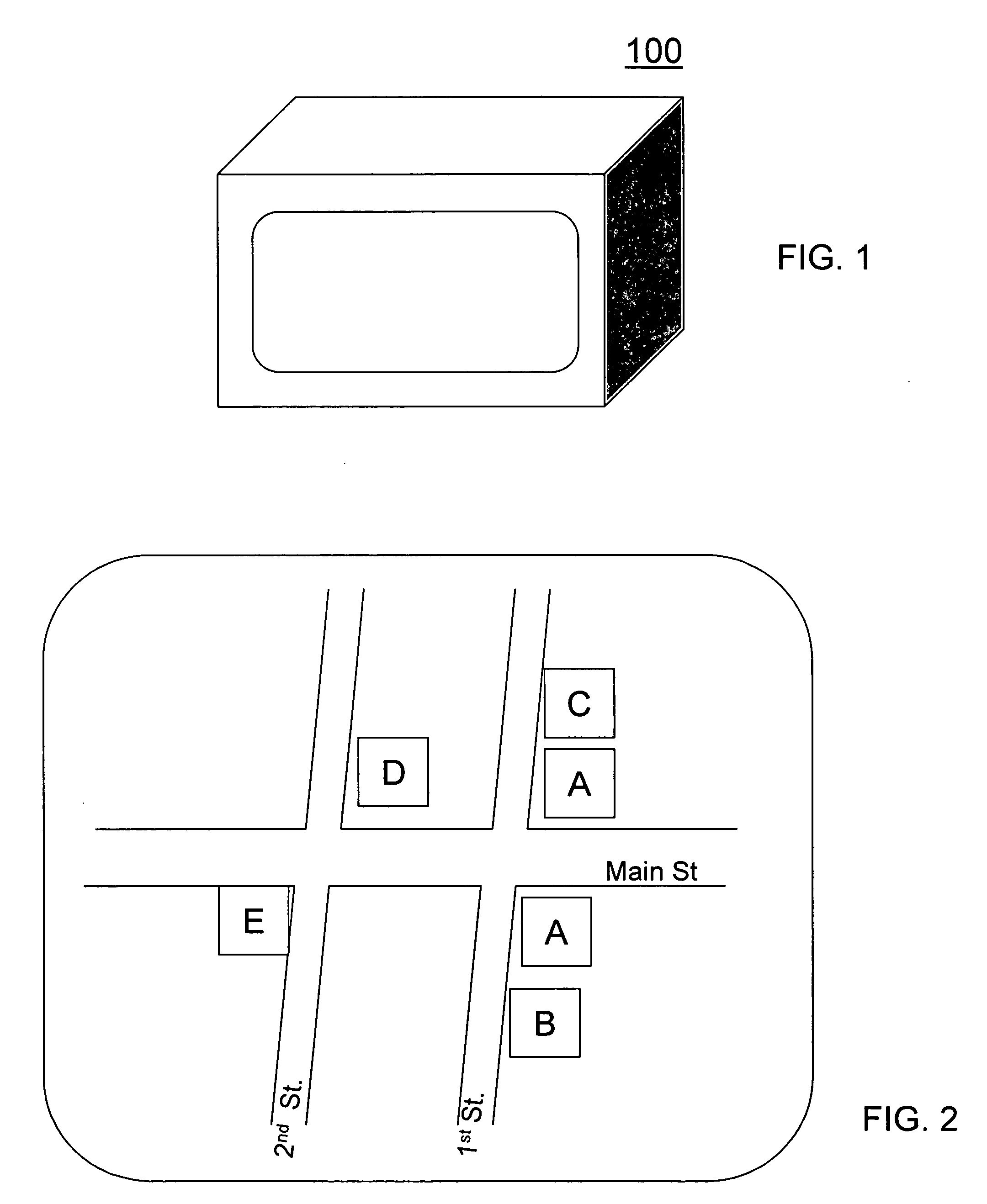
[0008]Turning to FIG. 1, a navigational aid 100 using a location receiver (e.g., a GPS receiver, a cellular triangulation unit or any other wireless signal-based triangulation unit (e.g., a WiFi-based triangulation unit)) that displays a map of the area around the navigational aid is shown. In one embodiment, the map can be moved (e.g., scrolled) to other locations other than the area around the navigational aid (e.g., to see a later part of a route or to see businesses further away). As shown in FIG. 2, the map contains information about a number of different business locations and their types. While the various business types are indicated with different letters in FIG. 2, the business types can also or alternatively be indicated by different graphical representations (e.g., icons) with the same or different colors. As shown in FIG. 2, all the business locations are indicated in a first mode (e.g., a default mode) in which filtering is not used for the display of business location...


PUM


Abstract

A navigational aid including an intelligent display mode and a communication system communicates with a vehicle's sensor system and/or historical- or time-based information to reduce the number of businesses that are displayed on the map by filtering out unneeded or less preferred services. When the vehicle's fuel level sensor detects that the fuel tank is almost empty, a message can be sent from the sensor system to the navigational aid such that the navigational aid can then begin showing a visual indication (e.g., text or graphical information such as an icon) of the location of fuel stations on the screen. Additionally, the location receiver indicates to the filter when the navigational aid is close to the programmed destination. At that point, the filter can be informed that it should start showing garages or areas where the vehicle can be parked without having cluttered the screen with parking garages that were not close to the destination. Similarly, when in need of other services (e.g., hotel or restaurant services), the navigational aid can display preferred brands (while omitting non-preferred brands) and make reservations when a communication system is included which is capable of communicating with the service provider. Additionally, prices or relative prices for the services may also be indicated.

Description

FIELD OF INVENTION[0001]The present invention is directed to a navigational aid (such as a GPS system) which includes context sensitive information, and in one embodiment to a system and method for filtering out or adding information to what a user sees or hears while using a navigational aid based on time-sensitive or application-specific information.DISCUSSION OF THE BACKGROUND[0002]A number of companies have begun releasing navigational aids (such as GPS systems) that can be carried on one's person or transported in a vehicle to aid in going from place to place. Some of those systems identify various types of businesses that are located within the field of view of the map in case the user has need of such a service. This includes the ability to see gas stations, restaurants, etc. as one drives around. However, cluttering up a screen with gas stations is not valuable when that vehicle's gas tank is mostly full. Moreover, cluttering up a screen with restaurants is not valuable afte...

Claims


Application Information

Patent Timeline
IPC IPC(8): G01C21/30
CPCG01C21/3697G01C21/3682
Inventor GOTTLIEB, MARK
Owner INSPIRED POSSIBILITIES LLC
Why Eureka
Try Eureka