Data mining in a digital map database to identify intersections located over hills and enabling precautionary actions in a vehicle

a technology of data mining and digital map database, which is applied in the field of data mining in a digital map database to identify intersections located over hills and enable precautionary actions in vehicles, can solve the problems of difficult to obtain consistent information about traffic accidents on roads in a large geographic region, such as the entire united states or europe, and achieve the effect of increasing control authority and sensitivity

Inactive Publication Date: 2009-12-03
HERE GLOBAL BV
View PDF99 Cites 35 Cited by
  • Summary
  • Abstract
  • Description
  • Claims
  • Application Information

AI Technical Summary

Benefits of technology

[0008]According to further aspects, a precautionary action system installed in a vehicle uses this database, or a database derived therefrom, in combination with a positioning system, to determine when the vehicle is at a location that corresponds to the location where a precautionary action should be taken. When the vehicle is at such a location, the precautionary action is taken, such as providing a warning to the vehicle operator, as the vehicle is approaching an intersection located over a hill. Alternatively, the precautionary action may consist of an actual modification of the operation or control of the vehicle, such as braking, accelerating, or maneuvering the vehicle, or activating a sensor. Alternatively, the precautionary action may include providing an input to an algorithm that also processes inputs from other sensors for taking such actions. Alternatively, the precautionary action may be an adjustment of sensitivities of other ADAS applications such as increasing the control authority and sensitivity of a lane departure warning or control system to lane edge approach and violation. In another alternative, the precautionary action may include a combination of any of these aforementioned actions.

Problems solved by technology

Accordingly, it is difficult to obtain consistent information about traffic accidents on roads in a large geographic region, such as the entire United States or Europe.
Moreover, data indicating locations where a statistically large number of traffic accidents occur may not indicate the causes of the accidents or how accidents can be avoided.

Method used


Image

  • Data mining in a digital map database to identify intersections located over hills and enabling precautionary actions in a vehicle
  • Data mining in a digital map database to identify intersections located over hills and enabling precautionary actions in a vehicle
  • Data mining in a digital map database to identify intersections located over hills and enabling precautionary actions in a vehicle

Examples


Embodiment Construction

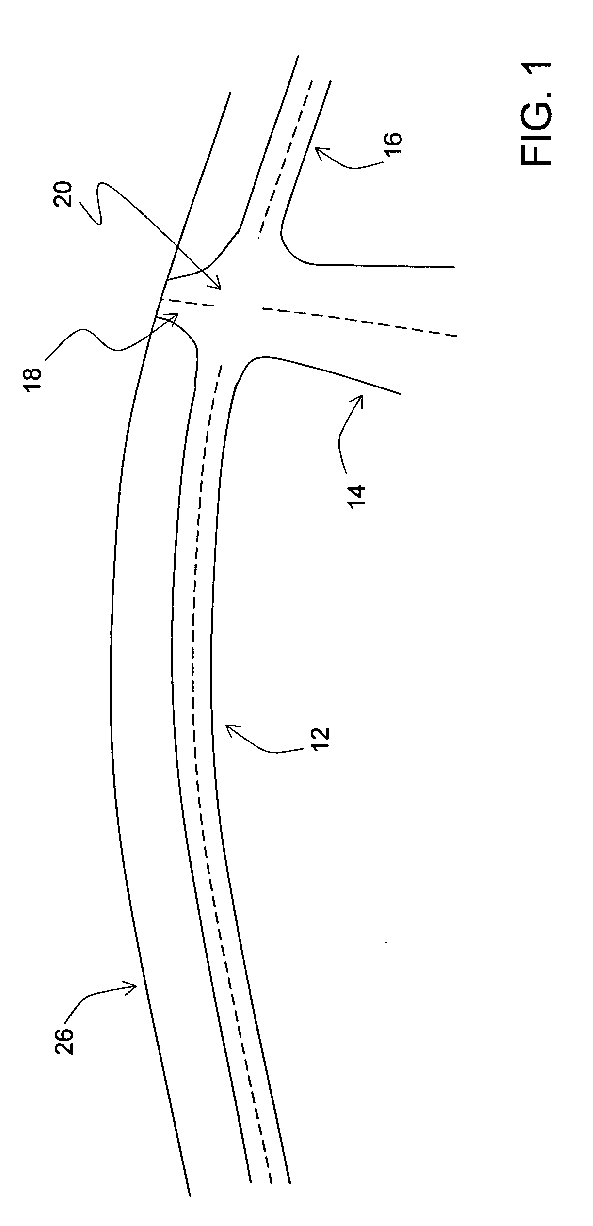
[0014]FIG. 1 depicts road segments 12, 14, 16 and 18. These road segments meet at an intersection 20. The road segment 12 extends over a top of the hill 26 so that the intersection 20 is located beyond the top of the hill 26 when a driver travels along the road segment 12 in the direction indicated by the arrow 22. Because of the shape of the hill, a vehicle driver traveling along the road segment 12 in the direction toward the intersection 20 may not have a good view of the intersection 20 or any vehicles approaching the intersection from the road segments 14, 16 and 18. Because of this, the intersection 20 is potentially hazardous.

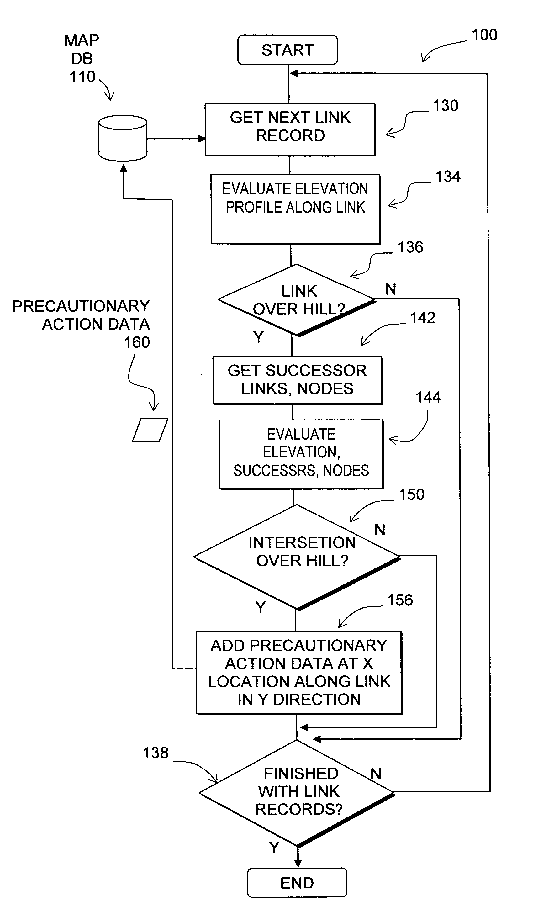
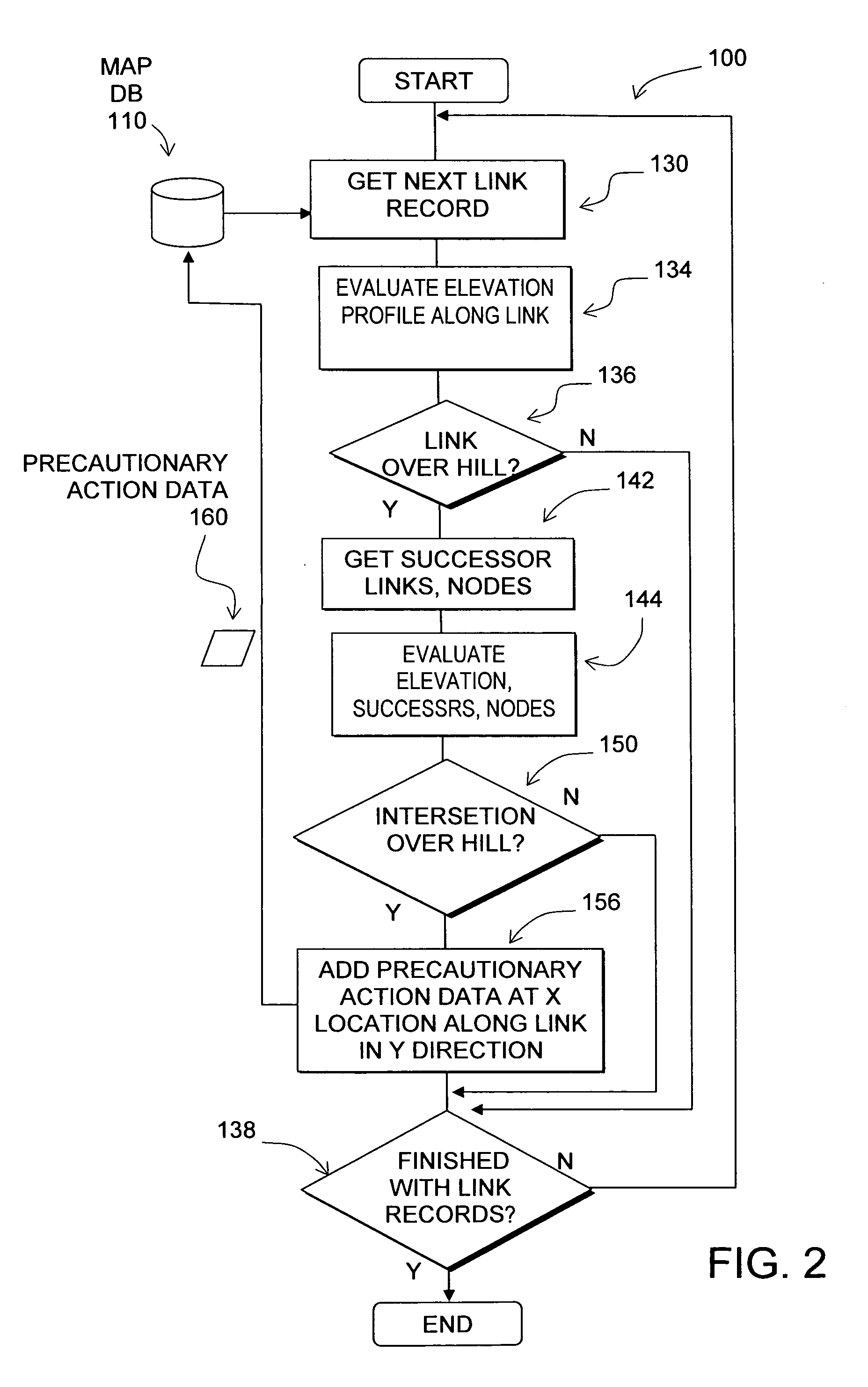
[0015]FIG. 2 is a flowchart of a process 100. The process 100 is performed by a software program or routine that is run on a suitable computing platform, such as a database server, PC or plurality of PCs coupled together for parallel computing applications.

[0016]The process 100 uses a database 10 that contains data that represents the road network in a r...


PUM


Abstract

Disclosed is a feature for a vehicle that enables taking precautionary actions in response to conditions on the road network around or ahead of the vehicle, in particular, an intersection located over a hilltop along a section of road. A database that represents the road network is used to determine locations where an intersection located over a hilltop is located along a section of road. Then, precautionary action data is added to the database to indicate a location at which a precautionary action is to be taken about the intersection located over a hilltop located along the section of road. A precautionary action system installed in a vehicle uses this database, or a database derived therefrom, in combination with a positioning system to determine when the vehicle is at a location that corresponds to the location of a precautionary action. When the vehicle is at such a location, a precautionary action is taken by a vehicle system as the vehicle is approaching an intersection located over a hilltop.

Description

REFERENCE TO RELATED APPLICATION[0001]The present patent application is related to the copending patent application Ser. No. ______, filed on the same date, entitled “DATA MINING TO IDENTIFY LOCATIONS OF POTENTIALLY HAZARDOUS CONDITIONS FOR VEHICLE OPERATION AND USE THEREOF,” Attorney Docket No. N0260US, the entire disclosure of which is incorporated by reference hereinBACKGROUND OF THE INVENTION[0002]The present invention relates to a method and system that enables taking a precautionary action in a vehicle, such as providing a warning to a vehicle driver about a potentially difficult or hazardous driving condition on the road network.[0003]Advanced driver assistance systems (“ADAS”), including active safety and fuel economy systems, have been developed to improve the comfort, efficiency, safety, and overall satisfaction of driving. Examples of these advanced driver assistance systems include adaptive headlight aiming, adaptive cruise control, lane departure warning and control, cu...

Claims


Application Information

Patent Timeline
Patent Type & Authority Applications(United States)
IPC IPC(8): G01C21/26G06F17/30
CPCG09B29/007G01C21/32G01C21/3844G01C21/3822G01C21/3837
Inventor DENARO, ROBERT
Owner HERE GLOBAL BV
Why Eureka
Try Eureka