
Displaying, processing and storing geo-located information

a geo-location and information technology, applied in the field of image display systems, can solve the problems of removing information that is valuable to a particular user from availability, and affecting the user's experience of pre-development imagery,

Inactive Publication Date: 2009-12-10
CHURCHILL NAVIGATION
View PDF16 Cites 95 Cited by
  • Summary
  • Abstract
  • Description
  • Claims
  • Application Information

AI Technical Summary

Benefits of technology

[0033]In still another aspect, a system for displaying geo-located imagery is provided that may include a client, a remote tile server storing a plurality of multiple resolution level orthogonal imagery sets, and a local tile server for communications between the remote tile server and the client. The client may be operable to generate a display for displaying the geo-located imagery. The client may be operable to control a user interface enabling a user to select for simultaneous display portions of at least two multiple resolution level orthogonal imagery sets of the plurality of multiple resolution level orthogonal imagery sets.

Problems solved by technology

Additionally, such systems do not easily allow for users to view changes in a particular area over time.
Furthermore, such systems, in replacing imagery, may remove from availability information that is valuable to a particular user.
However, once the imagery is replaced with newer imagery showing land development, the pre-development imagery may be lost to the user.
Also, changing imagery due to the replacement of existing imagery with newer imagery may be unwanted by many users.
Such unwanted changes may include, for instance, seasonal changes to plants and ground cover, changes to the positions of temporary and / or movable objects (e.g., cars, planes, equipment), and / or changes to development (new construction and / or demolition).

Method used


Image

  • Displaying, processing and storing geo-located information
  • Displaying, processing and storing geo-located information
  • Displaying, processing and storing geo-located information

Examples


Embodiment Construction

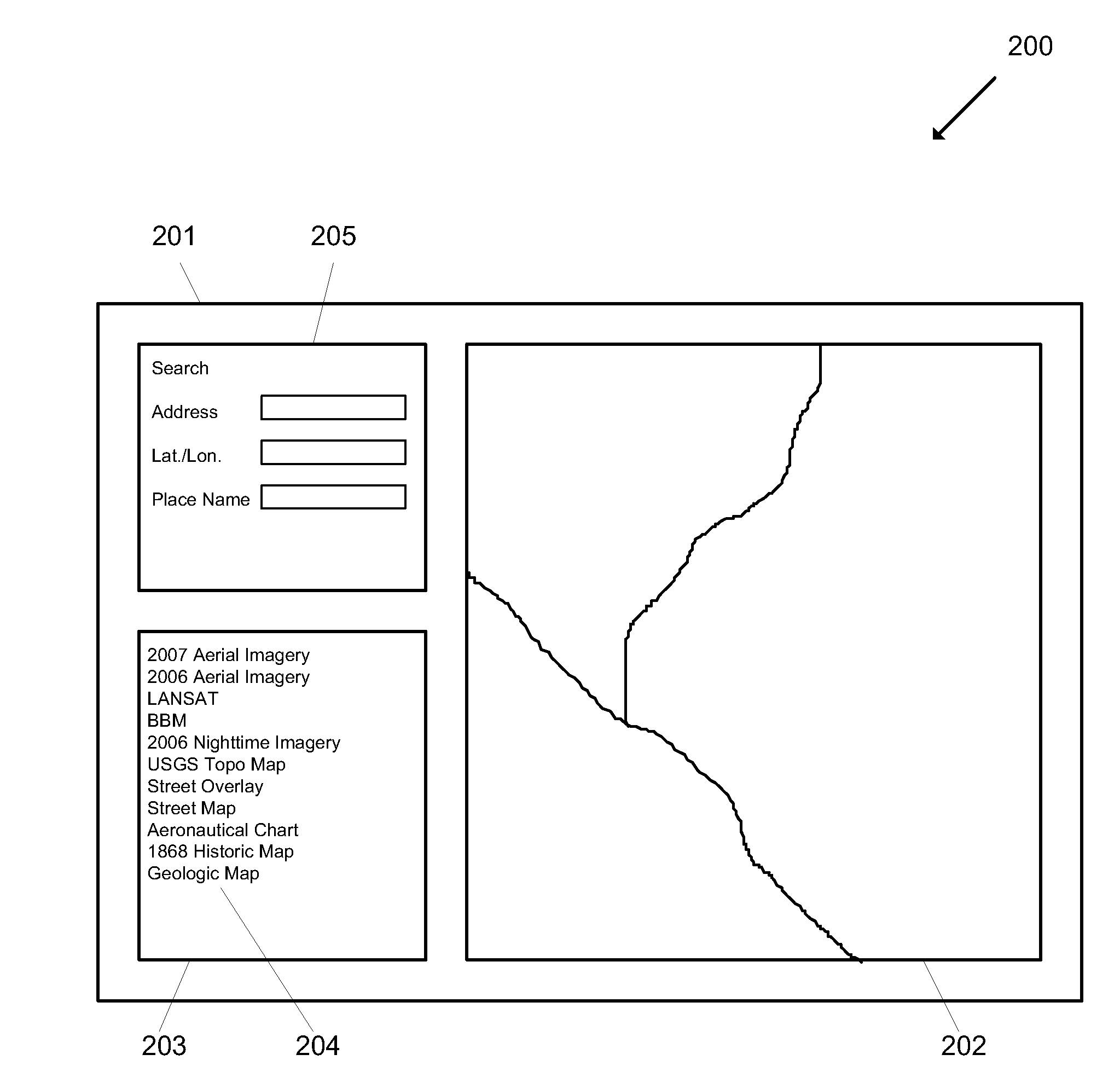
[0043]In the following description, the invention is set forth in the context of apparatuses and methods for displaying, processing and storing geo-located information including geo-located imagery. Embodiments described herein include systems for displaying geo-located images where the displayed images may be selected from and / or created from a plurality of imagery sets.

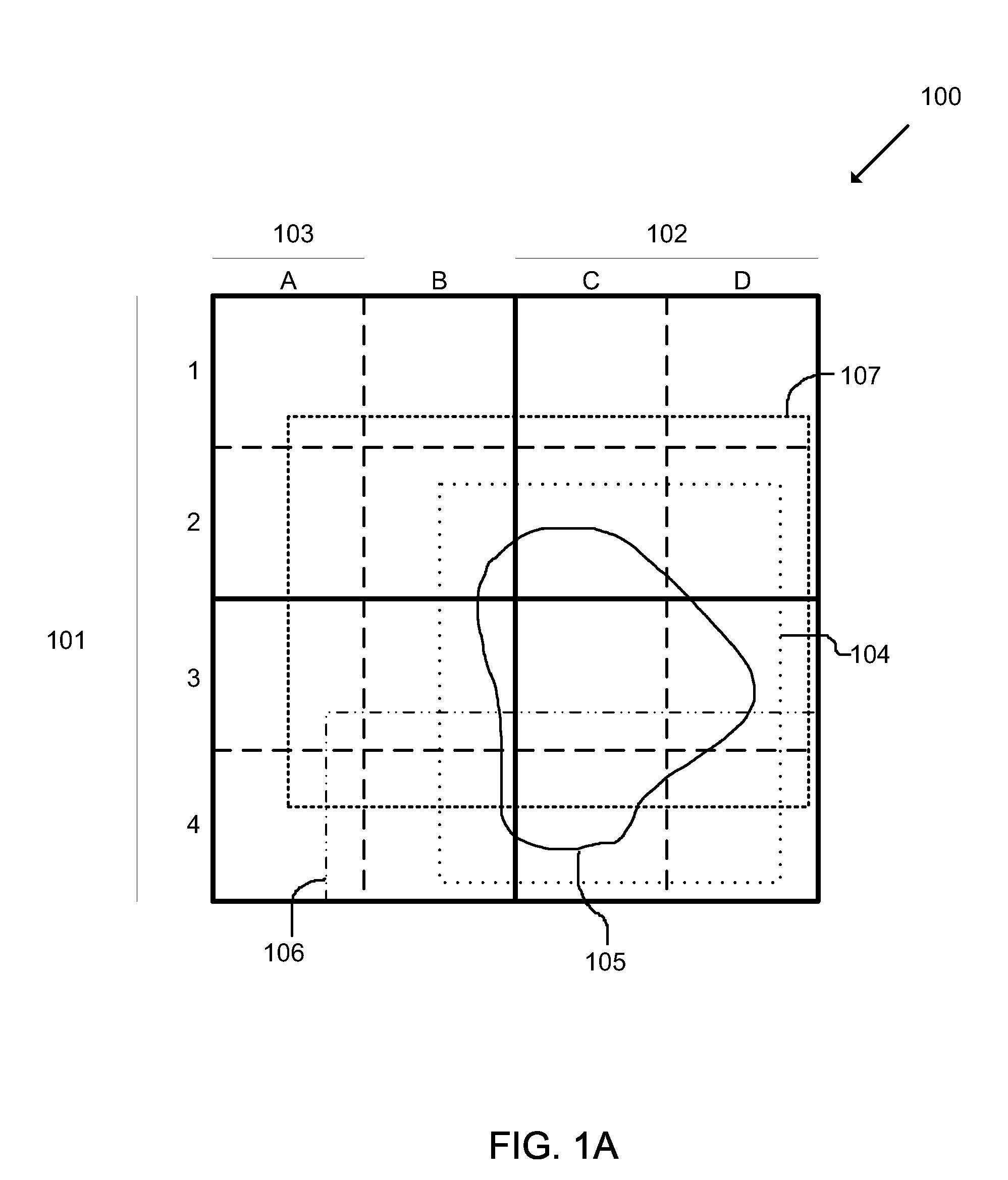
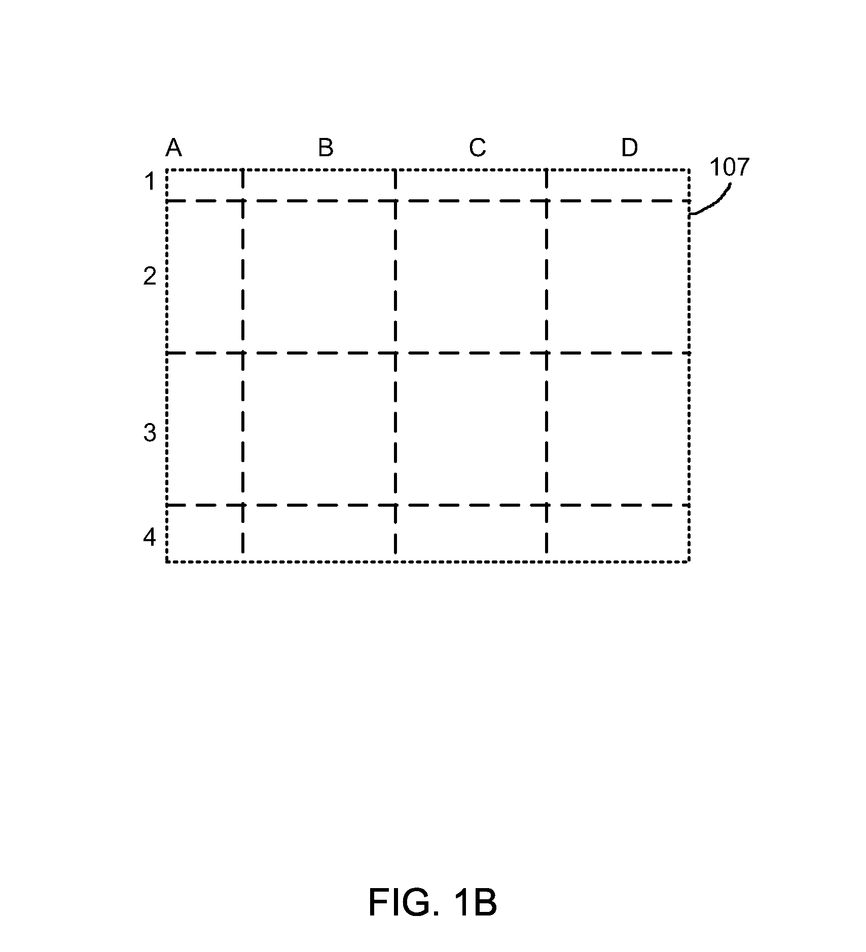
[0044]One method of displaying, processing and storing geo-located imagery is to organize the imagery into a hierarchical data structure such as a quadtree. The quadtree is a multi-level structure with each level representing the same surface area of the Earth with higher (e.g., higher numerical designation) levels representing the surface area with a higher degree of resolution. The imagery contained within each level of the quadtree may be orthogonal imagery captured from a location substantially orthogonal to the reference ellipsoid of the Earth. In one embodiment, the first level of the quadtree represents the e...


PUM


Abstract

Systems, apparatuses and methods for displaying geo-located imagery are described. The systems may utilize multiple independent quadtree data structures to organize and display geo-located imagery from a variety of sources. A user of the systems described herein may select which geo-located imagery quadtree sets are to be displayed. The user may further select the priority order for the multiple geo-located imagery quadtree sets. The systems may include remote tile servers in communication over the Internet with a local tile server and client at the user's location. The multiple geo-located imagery quadtree sets may include imagery information organized by time of capture, method of capture, and / or source. The imagery may, for example, include photographic imagery, map imagery, and / or charts. The imagery may be supplied by a variety of sources including users and third party imagery providers.

Description

FIELD OF THE INVENTION[0001]The present invention relates to image display systems in general and to geo-located digital imagery display systems in particular.BACKGROUND OF THE INVENTION[0002]Known geo-located imagery systems such as for example Google™ Earth and Microsoft™ Virtual Earth™ enable a user to view geo-located imagery of the Earth's surface (e.g., aerial imagery) displayed on a model of the Earth. The display is typically on a computer monitor and includes a simulated view of a portion of the surface of the Earth from a virtual viewpoint. The user may pan, zoom and rotate the viewpoint. Known geo-located imagery systems may also allow a user to tilt the virtual viewpoint so that the user may select to look straight down from a virtual viewpoint above the Earth's surface, to look parallel to the Earth's surface, or to look at any angle in between. Known geo-located imagery systems may also be capable of rendering the surface of the Earth in three dimensions. For example, ...

Claims


Application Information

Patent Timeline
Patent Type & Authority Applications(United States)
IPC IPC(8): G09G5/00
CPCG06F17/30241G06T17/05G06T17/005G06F17/3028G06F16/29G06F16/51
Inventor BALOGH, ANDRASBLIND, TOMCHURCHILL, TOMFIANO, VINCENT
Owner CHURCHILL NAVIGATION
Features
  • Generate Ideas
  • Intellectual Property
  • Life Sciences
  • Materials
  • Tech Scout
  • Unparalleled Data Quality
  • Higher Quality Content
  • 60% Fewer Hallucinations
Learn More