Method for generating a customized composite map image and electronic apparatus for implementing the same

a composite map and image technology, applied in surveying and navigation, navigation instruments, instruments, etc., can solve the problems of not being able to meet the needs of service subscribers and not providing customized maps and poi by telecommunication service providers and pnd manufacturers

Active Publication Date: 2011-07-28
MITAC INT CORP
View PDF4 Cites 21 Cited by
  • Summary
  • Abstract
  • Description
  • Claims
  • Application Information

AI Technical Summary

Problems solved by technology

However, maps and POI provided by the telecommunication service providers and the PND m

Method used


Image

  • Method for generating a customized composite map image and electronic apparatus for implementing the same
  • Method for generating a customized composite map image and electronic apparatus for implementing the same
  • Method for generating a customized composite map image and electronic apparatus for implementing the same

Examples


Embodiment Construction

[0027]Before the present invention is described in greater detail, it should be noted that like elements are denoted by the same reference numerals throughout the disclosure.

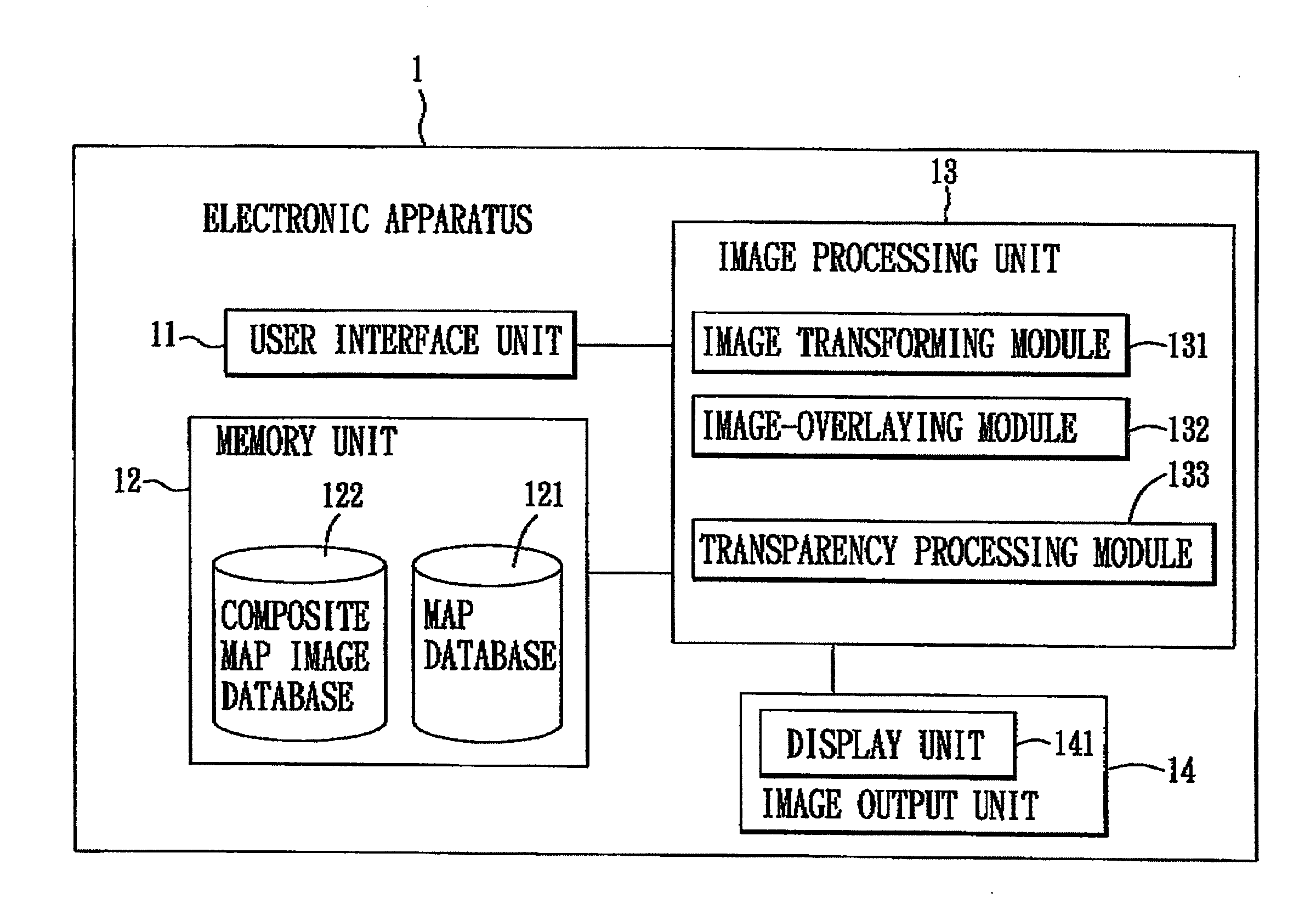
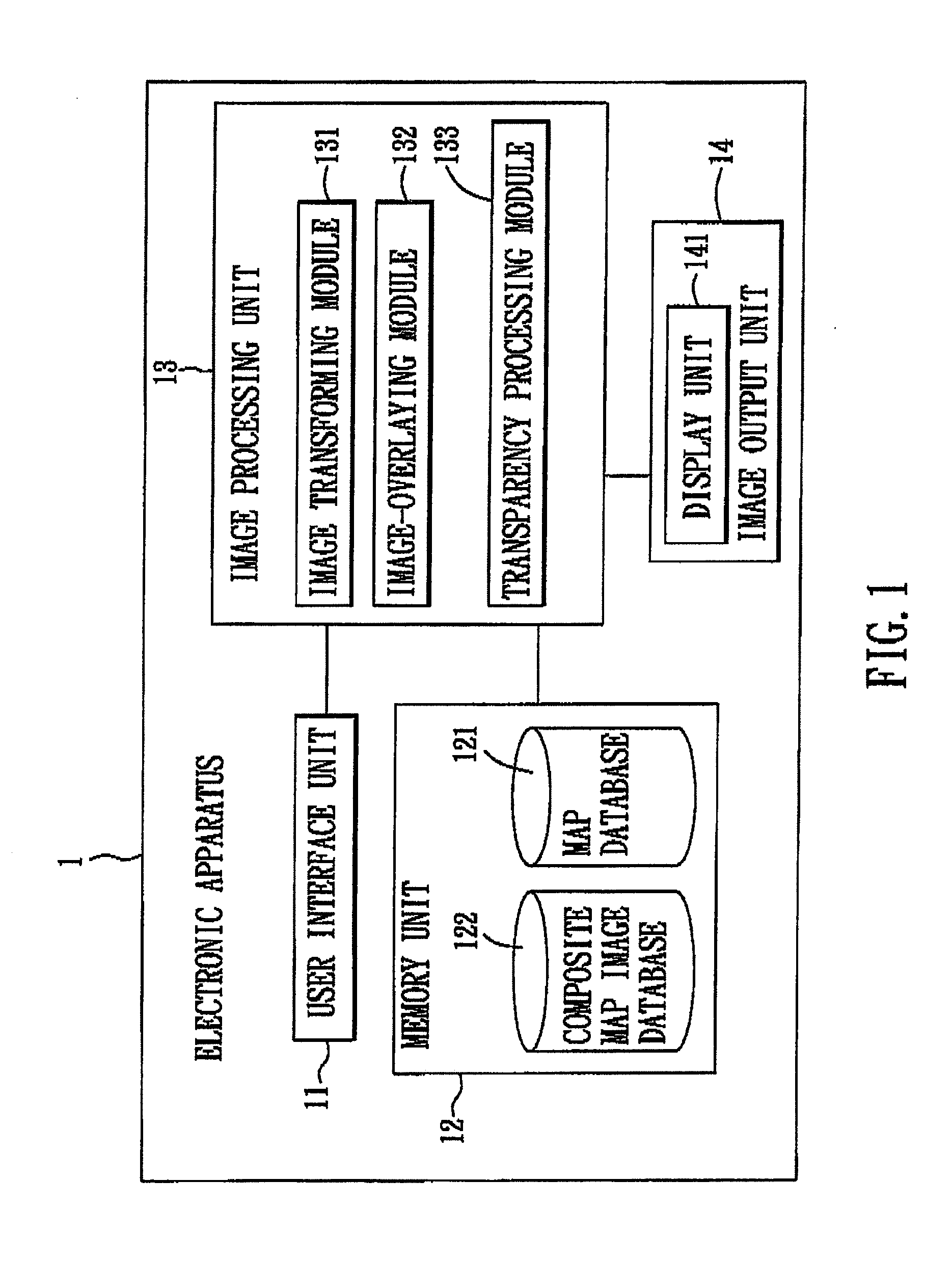
[0028]Referring to FIG. 1, the first preferred embodiment of an electronic apparatus 1 according to the present invention is exemplified as a personal navigation device (PND), and includes a user interface unit 11, a memory unit 12, an image processing unit 13, and an image output unit 14.

[0029]The user interface unit 11 is coupled to the image processing unit 13 for providing a user input that specifies a location of an area of interest, and a user-specified input image of the area of interest, to the image processing unit 13.

[0030]The memory unit 12 stores a map database 121, a composite map image database 122, and the user-specified input image of the area of interest. The map database 121 contains a reference map that encompasses the area of interest. The memory unit 12 further stores information of a set of...


PUM


Abstract

A method is to be implemented by an electronic apparatus having a map database established therein, and includes the steps of: receiving a user-specified input image of an area of interest, and obtaining from the map database a reference map that encompasses the area of interest; selecting a set of feature points in the user-specified input image, and a set of map points in the reference map that correspond in geographical features to the feature points; transforming the user-specified input image according to positional differences between the feature points and the corresponding map points to thereby obtain a to-be-registered image having adjusted feature points corresponding in position to the map points; overlaying the to-be-registered image onto the reference map to thereby obtain a customized composite map image; and outputting the customized composite map image.

Description

CROSS-REFERENCE TO RELATED APPLICATION[0001]This application claims priority of Taiwanese Application No. 099102061, filed on Jan. 26, 2010.BACKGROUND OF THE INVENTION[0002]1. Field of the Invention[0003]The present invention relates to a method for generating a map image, more particularly to a method for generating a customized composite map image.[0004]2. Description of the Related Art[0005]The Global Positioning System (GPS) was originally developed for military purpose, but has recently been employed in various commercial applications, such as GPS navigation. As GPS navigation becomes ubiquitous, more and more telecommunication service providers and personal navigation device (PND) manufacturers now provide location-based services, e.g., provision of points of interest (POI) according to locality of service subscribers.[0006]However, maps and POI provided by the telecommunication service providers and the PND manufacturers are not customized and might not satisfy needs of the s...

Claims


Application Information

Patent Timeline
IPC IPC(8): G09G5/00
CPCG01C21/32G01C21/3811G01C21/3856
Inventor HUNG, SHUN-CHENG
Owner MITAC INT CORP
Why Eureka
Try Eureka