System and Method for Creating and Displaying Map Projections related to Real-Time Images

a technology of real-time images and projections, applied in maps/plans/charts, instruments, computing, etc., can solve the problems of limited information that applications provide about the user's surroundings, disorient the user, and distract the user, so as to improve the understanding of the current surroundings and improve navigation.

Active Publication Date: 2011-08-04
UNCHARTED SOFTWARE INC
View PDF11 Cites 59 Cited by
  • Summary
  • Abstract
  • Description
  • Claims
  • Application Information

AI Technical Summary

Benefits of technology

[0006]According to one aspect there is provided a navigation system that provides correlation between real-world images and virtual map images and allows improved navigation. The virtual map images include for example, virtual aerial and/or satellite imagery, raster or v

Problems solved by technology

However, it can be distracting for a user to view their surroundings while looking at a secondary device.
It can also be disorienting for a user to try to relate the animated map view to the real world images seen by the user and attempt navigation at the same time.
As well, these GPS devices/applications provide a limited amount of information about the user's surroundings.
There are also some 3D GPS systems that provide a limited amount of navigation information on windshields of vehicles

Method used


Image

  • System and Method for Creating and Displaying Map Projections related to Real-Time Images
  • System and Method for Creating and Displaying Map Projections related to Real-Time Images
  • System and Method for Creating and Displaying Map Projections related to Real-Time Images

Examples


Embodiment Construction

Data Processing System 100

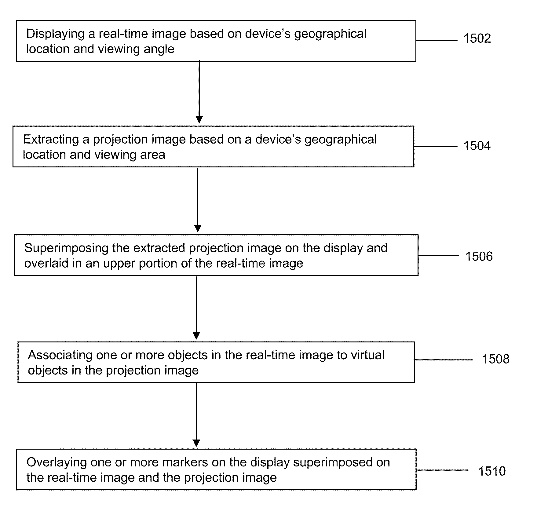
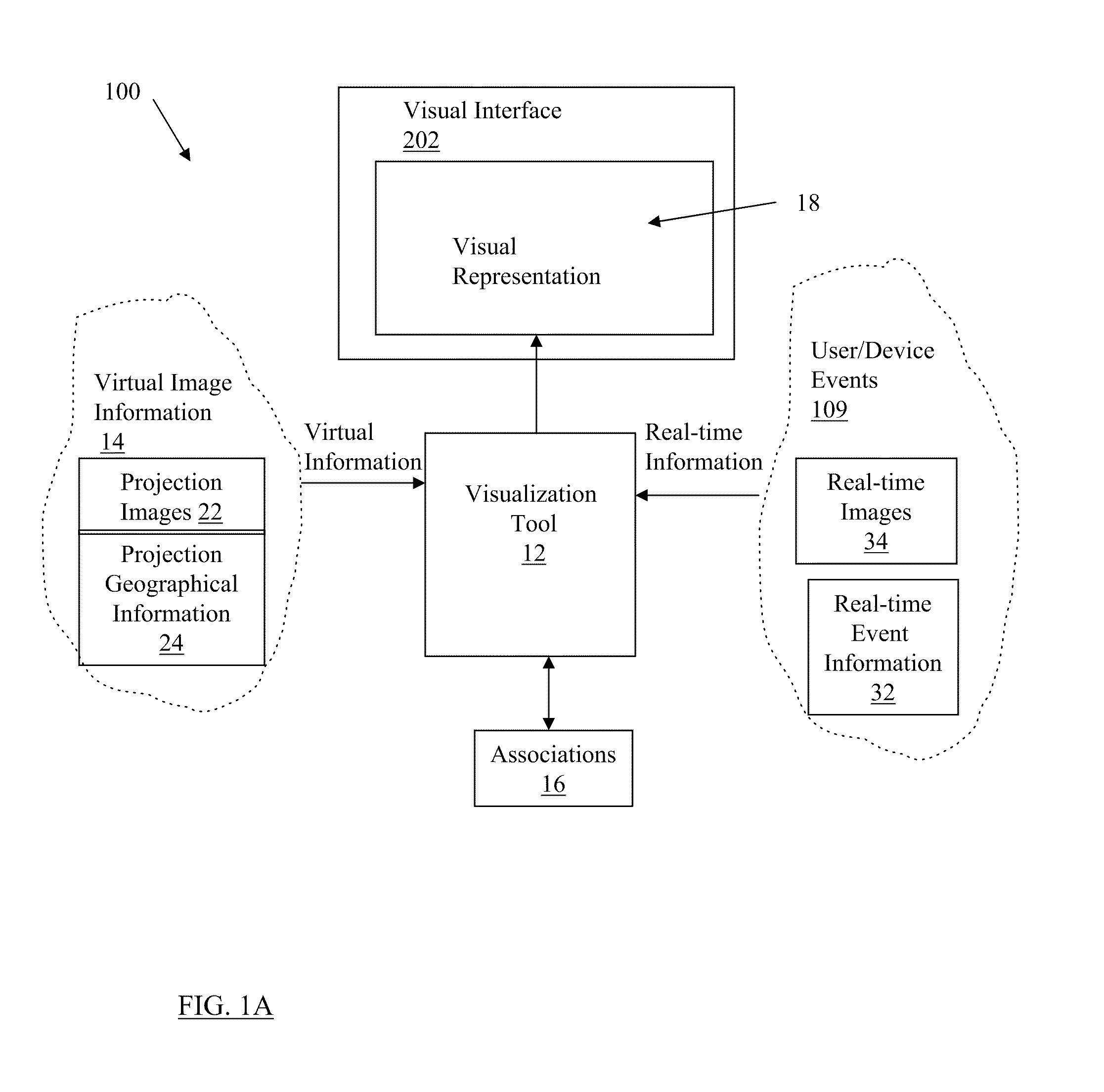
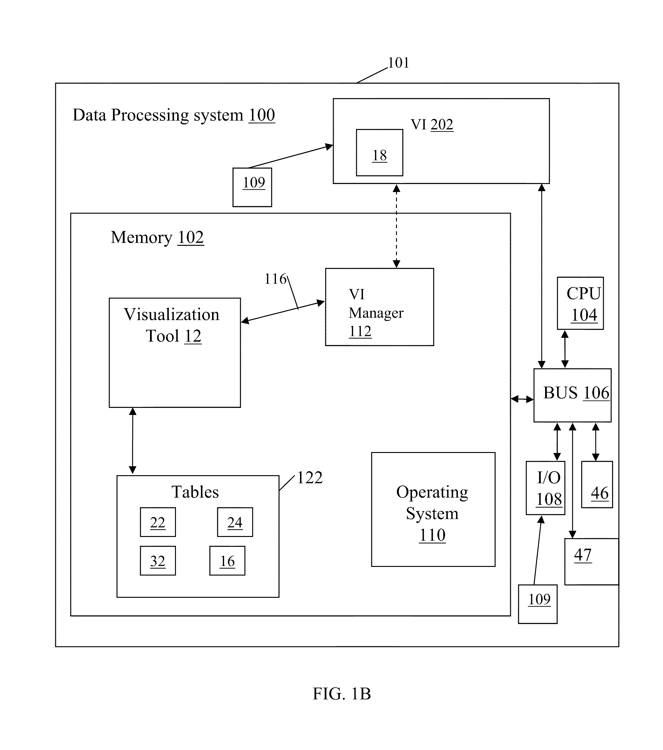
[0018]Referring to FIG. 1A, a visualization data processing system 100 includes a visualization tool 12 for retrieving and processing a collection of virtual image information 14 as input data elements to a user interface 202. The virtual image information 14 provides satellite and / or aerial imagery as projection images 22 (also referred to as map projections or virtual images herein). The virtual image information 14 further provides geographical information 24 associated with the projection images 22. The geographical information 24 can include, for example, location information associated with the projected images 22, names of locations within the projection images, or other characterizing information, physical characteristics of objects within the projection images 22. The geographical information 24 can include any information that may be used for example, in graphical information systems (GIS). The visualization tool 12 is further configured for proce...


PUM


Abstract

There is provided a method and system for creating and displaying a map projection of a device's real-time viewing area to depict virtual objects, the virtual objects providing a reflected view of real-time objects displayed within the device's viewing area, the method comprising: displaying a real-time image of the device's viewing area taken from a geographical location on a display; retrieving the map projection for revealing the reflected view as an elevated view of a ground surface about the device's current geographical location and in accordance with the device's viewing area; superimposing the map projection on the display and overlaid in an upper portion of the real-time image; and defining one or more markers configured to show a relationship between the map projection and the real-time image, each marker overlaid on the display and configured to connect between the virtual object in the map projection and the corresponding real-time object on the real-time image.

Description

FIELD OF THE INVENTION[0001]This application relates to an interactive visual presentation of a map projection on a user interface. Specifically, the application relates to a system and method for displaying a map projection on a user interface for depicting a reflected view of real-time objects displayed within a user / device's viewing area.BACKGROUND OF THE INVENTION[0002]Currently, there exists many navigation systems that provide information about a user's surroundings and geographical information. Some GPS navigation systems appear as an animated 2D image on a specific device such as a BlackBerry®, iPhone®, cell phone or a specific GPS device such as Garmin®. These 2D systems are designed to provide navigation information on an animated street map view. The GPS systems can provide a street view, a satellite view and a hybrid view of a map. However, it can be distracting for a user to view their surroundings while looking at a secondary device. It can also be disorienting for a u...

Claims


Application Information

Patent Timeline
IPC IPC(8): G06K9/36G06K9/46
CPCG06T17/05G06T19/006G09B29/106
Inventor WRIGHT, WILLIAMKAPLER, THOMASSENIOR, ROBIN
Owner UNCHARTED SOFTWARE INC
Why Eureka
Try Eureka