Proximate beacon identification

a beacon and proximate technology, applied in the field ofproximate beacon identification, can solve the problems of not providing the fidelity of some user experience, the distance from the user to a particular object may not meet the granularity requirements to properly interact, and the current global positioning system (gps) and/or other location identification services used on mobile devices may not provide the fidelity needed for some user experience,

Active Publication Date: 2013-10-03
MICROSOFT TECH LICENSING LLC
View PDF49 Cites 81 Cited by
  • Summary
  • Abstract
  • Description
  • Claims
  • Application Information

AI Technical Summary

Benefits of technology

[0005]Accordingly, among other things, one or more techniques and / or systems are provided that utilize a signal transmissions from one or more local beacons to identify a potential location of a mobile device (e.g., and thus an associated user using the mobile device). For example, the mobile device may detect signals (e.g., wireless signals) from one or more beacons, respectively positioned in different locations (e.g., stores, throughout a building, etc.) of a larger area. The received signals can be analyzed and filtered to identify a set of signals from a proximate beacon (e.g., closest to the mobile device). Further, if the user is non-stationary (e.g., moving through a shopping center), a non-stationary condition can be detected, and a proximate beacon may not be identified (e.g., as the user may be proximate to several beacons while moving). The location awareness provided herein can help determine a potential location of the mobile device / user relative to a known location (e.g., the proximate beacon may be known to be installed in a particular store). In this way, rich content (e.g., relative to the user's location) can be provided to the user (e.g., on-the-fly, on the mobile device).

Problems solved by technology

Current global positioning systems (GPS) and / or other location identification services used on mobile devices may not provide needed fidelity for some user-experiences, such as applications running on the mobile device, and / or information provided to mobile device data providers.
For example, the GPS systems can have an error range of thirty to fifty feet, which may not provide needed fidelity when the user-experience needs the user to be immediately (or at least substantially) proximate to a specific location.
Further, while the GPS and mobile signal triangulation can provide an approximate position of the user relative to a mapped point, a distance from the user to a particular object may not meet granularity requirements to properly interact, such as identifying a location from several overlapping locations.
Additionally, GPS-type location tracking loses reliability when a mobile device is inside a building or under cover (e.g., parking garage).
Even in optimal conditions, a GPS may not be able tell that the user is inside a particular building, standing in front of a particular display in a store, etc.

Method used


Image

  • Proximate beacon identification
  • Proximate beacon identification
  • Proximate beacon identification

Examples


Embodiment Construction

[0017]The claimed subject matter is now described with reference to the drawings, wherein like reference numerals are generally used to refer to like elements throughout. In the following description, for purposes of explanation, numerous specific details are set forth in order to provide a thorough understanding of the claimed subject matter. It may be evident, however, that the claimed subject matter may be practiced without these specific details. In other instances, structures and devices are shown in block diagram form in order to facilitate describing the claimed subject matter.

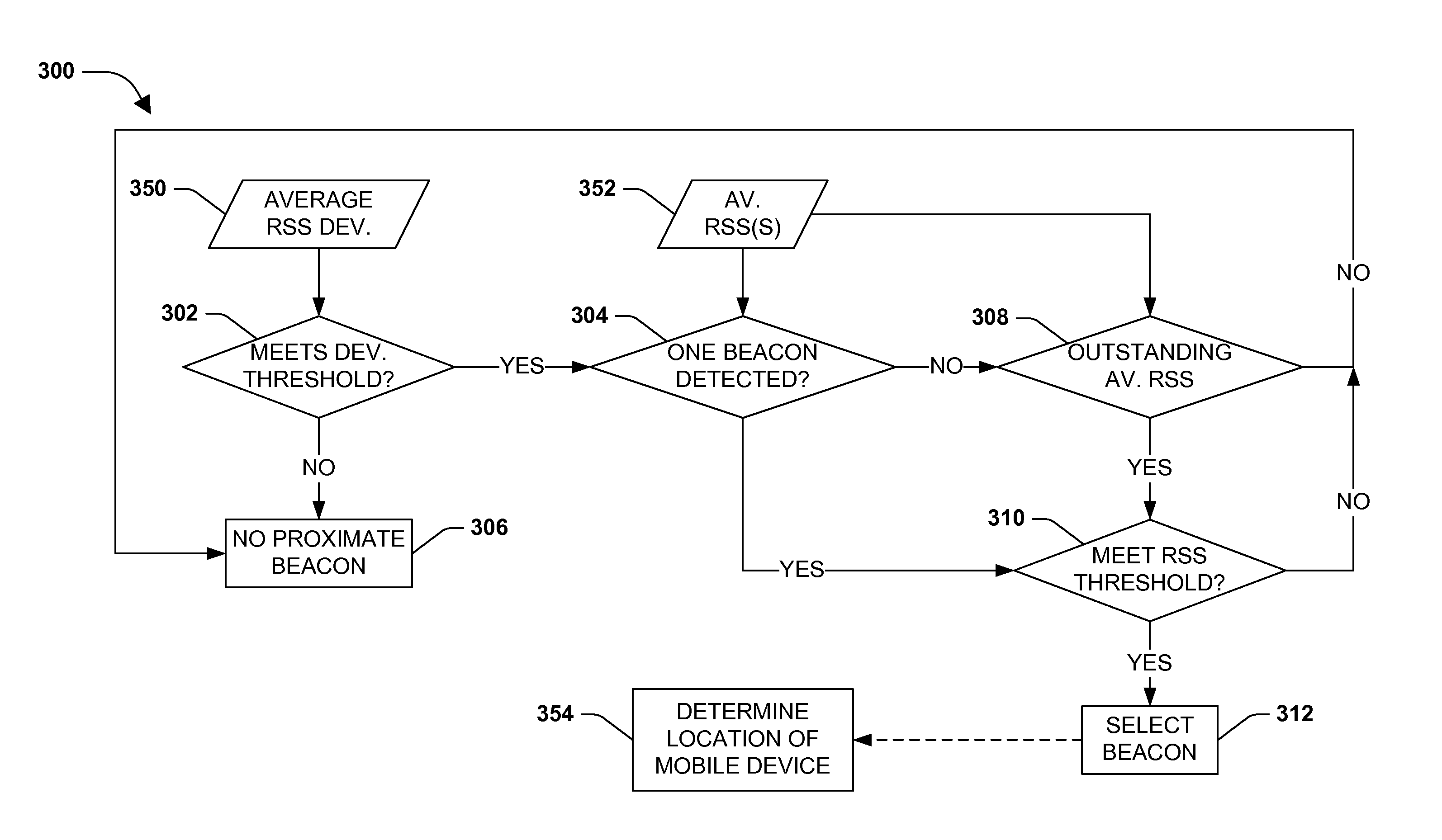
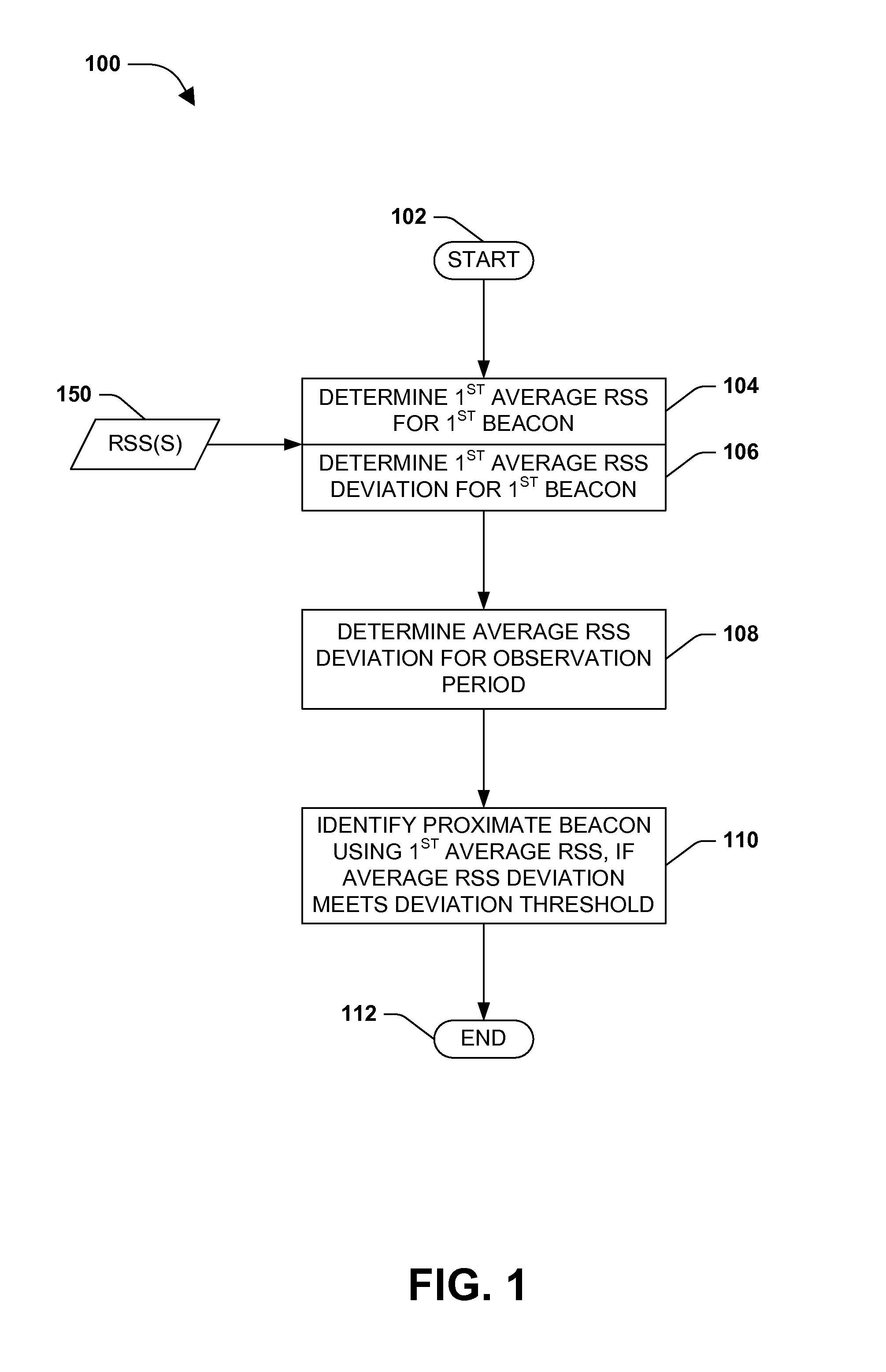
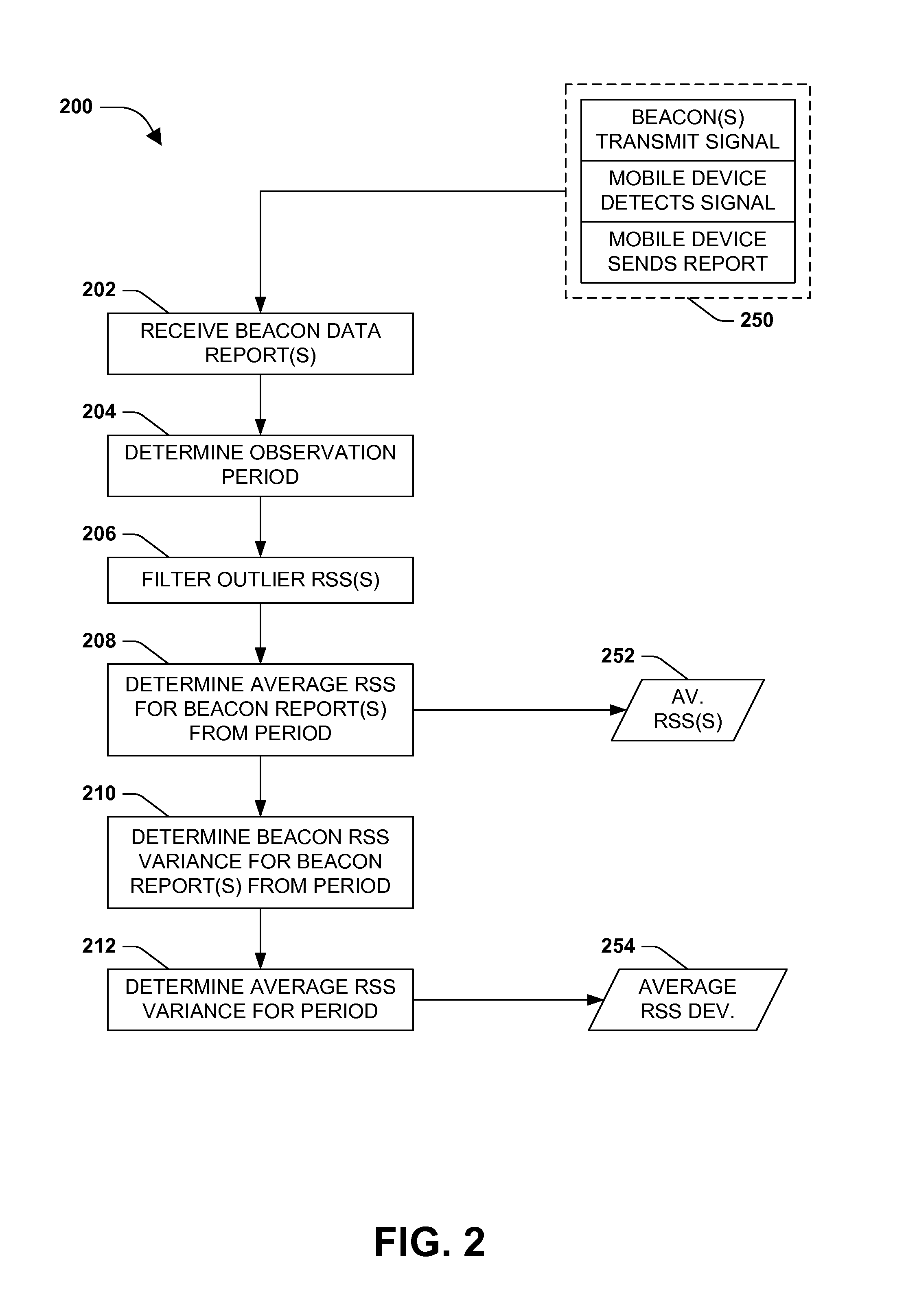
[0018]As provided herein, a method may be devised that can provide for identifying a location of a mobile device (e.g., and the user of the mobile device) in proximity to a beacon device. That is, for example, one or more beacons may be respectively located in portions (e.g., stores) of an area (e.g., a mall). In this example, the respective beacons can output a wireless signal that can be detected by t...


PUM


Abstract

Among other things, one or more techniques and/or systems are disclosed for identifying a proximate beacon to a mobile device. One or more first received signal strengths (RSSs), relative to the mobile device, may be received and used to determine a first average signal strength (RSS) and a first average RSS deviation for a first beacon during an observation period. An average RSS deviation for the observation period can be determined using the first average RSS deviation (e.g., and other average RSS deviations). If the average RSS deviation meets a desired deviation threshold, the first beacon may be identified as the proximate beacon. In this manner, if the user of the mobile device consents to the same, the user may be provided with relevant information (e.g., advertisements) on the mobile device while in a locale (e.g., store) corresponding to the (known) location of the beacon, for example.

Description

BACKGROUND[0001]Computing devices have become more portable and mobile devices have become more interactive with a user's surroundings. For example, a mapping application running on the user's mobile device (e.g., smartphone) may allow the user to identify their approximate location on a map displayed on the mobile device. Further, points of interest, retails establishments, entertainment venues, and more, can be indicated on such a map, for example, which can be searched for, and / or identified as the user moves through an area. Typically, mobile devices use global positioning systems (GPS), which utilize satellite triangulation, or some sort of signal triangulation (e.g., mobile phone signal) to identify the approximate location of the user. This location information can be used by various applications on the user's device, such as to provide appropriate and relevant local information, identify the user's location for social networking, and more.SUMMARY[0002]This Summary is provide...

Claims


Application Information

Patent Timeline
Patent Type & Authority Applications(United States)
IPC IPC(8): H04W24/00H04W4/029
CPCH04W4/028G01S5/02G01S5/0278H04W64/00H04W4/02H04W24/08G01S5/14H04W4/029
Inventor UN, EDWARD DING-BONGZHAO, JUNWANG, KAIMU, HAILONGXU, ZEYONGSU, ZHIYANG
Owner MICROSOFT TECH LICENSING LLC
Why Eureka
Try Eureka