Supercharge Your Innovation With Domain-Expert AI Agents!

Three/four dimensional data management and imaging for big oilfield data

a technology of oilfield measurement data and three/four dimensional data, applied in seismology for waterlogging, instruments, optics, etc., can solve the problems of reducing and affecting the accuracy of the data

Active Publication Date: 2015-08-27
PETRABYTES CORP
View PDF3 Cites 0 Cited by
  • Summary
  • Abstract
  • Description
  • Claims
  • Application Information

AI Technical Summary

Benefits of technology

The patent text describes a method, computer-readable storage media, and a system for storing and managing measurements taken in oilfields or wellbores. The method involves receiving raw data from oilfield or wellbore monitoring devices and converting it to image rasters without down-sampling. Each image raster is assigned a unique identifier (UID) and stored along with the assigned UID. The technical effect of this patent text is that it provides a way to store and manage oilfield or wellbore measurements in a more efficient and precise way.

Problems solved by technology

Traditional techniques are inadequate for analyzing such large volumes of data, and most techniques decimate the data.
As a result, the original resolution of the data can be lost and specific events particular times may not be analyzed and may instead be lost in the decimation or downsampling.

Method used


Image

  • Three/four dimensional data management and imaging for big oilfield data
  • Three/four dimensional data management and imaging for big oilfield data
  • Three/four dimensional data management and imaging for big oilfield data

Examples


Embodiment Construction

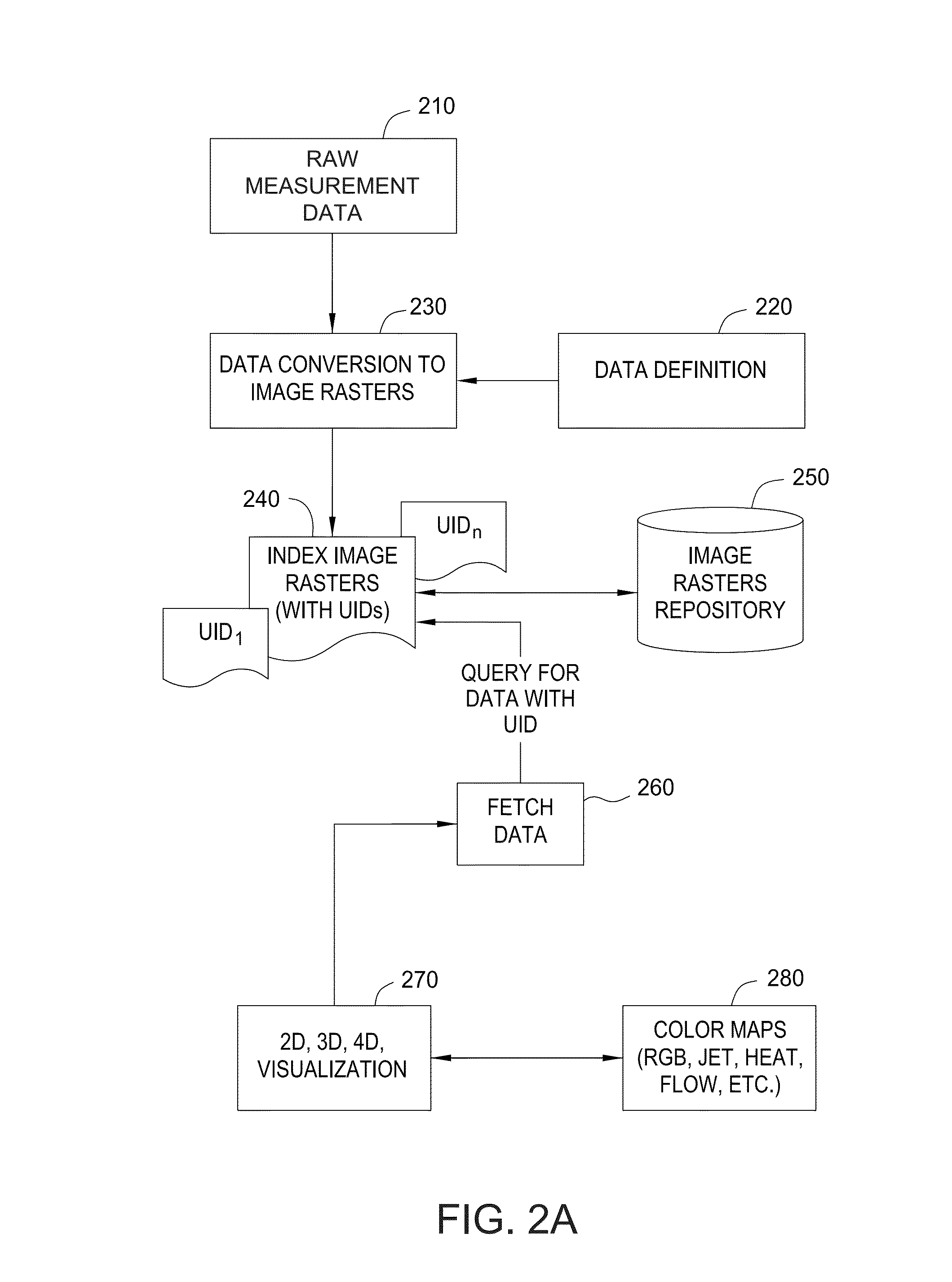
[0025]Collecting data during wellbore monitoring and making oilfield measurements such as geophone data (seismic) and airborne surveys, may produce large amounts of data, depending on the time interval and frequency of data measurements. Integrated sensing systems such as distributed temperature and acoustic sensing (DTAS) may also generate large data. For example, DAS data, when gathered at high frequency may generate on the order of 200 GB in a single day. As another example, distributed temperature measured along the length of the wellbore every minute, would generate 1,440 temperature profiles (24 hours×60 minutes=1,440 profiles), where each profile includes tens, hundreds, or even thousands of temperature measurements along the length of the wellbore. Embodiments disclosed herein provide techniques for visualizing a large volume of oilfield or wellbore measurements.

[0026]FIG. 2A illustrates an approach for storing and visualizing large oilfield measurement or reservoir monitori...


PUM


Abstract

Oilfield and wellbore data may include geophone data (seismic) and airborne surveys such as microseep data, as well as fiber optic measurements collected utilizing a distributed sensing system. Continuous monitoring of various oilfield and wellbore properties, such as temperature, pressure, Bragg gradient, acoustic, and strain, and the like, may generate a large volume of data, possibly spanning into several terabytes. Embodiments of the present invention provide techniques for visualizing a large volume of such measurements taken in an oilfield or wellbore without down-sampling measurement data.

Description

CROSS-REFERENCE TO RELATED APPLICATIONS[0001]This application claims the priority benefit of provisional U.S. patent application entitled “DATA IMAGING OF RESEVOIR MONITORING DATA,” having Ser. No. 61 / 943,207 and filed on Feb. 21, 2014, which is incorporated herein by reference in its entirety.BACKGROUND OF THE INVENTION[0002]1. Field of the Invention[0003]Embodiments of the present invention generally relate to methods and apparatus for analyzing measurements taken in a wellbore, or more generally in an area or oilfield with potential hydrocarbons. In particular, embodiments of the present invention relate to methods and apparatus for three / four dimensional data management and imaging of big oilfield measurement data.[0004]2. Description of the Related Art[0005]Oilfield measurements, including geophone data (seismic) and airborne surveys such as microseep data, can help in characterizing the subsurface with geological mapping and hydrocarbon detection. The data gathered from these ...

Claims


Application Information

Patent Timeline
Patent Type & Authority Applications(United States)
IPC IPC(8): G01V1/24G01V1/18G01V1/34G01V1/40
CPCG01V1/24G01V1/40G01V2210/74G01V1/345G01V1/181G01V1/34
Inventor GUNTURU, SASHI B.MORGAN, DANIEL H.
Owner PETRABYTES CORP
Features
  • R&D
  • Intellectual Property
  • Life Sciences
  • Materials
  • Tech Scout
  • Unparalleled Data Quality
  • Higher Quality Content
  • 60% Fewer Hallucinations
Learn More