METHOD OF OPTIMIZED PATH PLANNING FOR UAVs FOR THE PURPOSE OF GROUND COVERAGE

a technology of optimized path planning and ground coverage, applied in the direction of process and machine control, energy saving arrangements, instruments, etc., can solve the problems of requiring a great deal of power for such uavs to perform tasks such as surveillance, weapons delivery, and flight over long distances

Active Publication Date: 2017-06-08
IBM CORP
View PDF10 Cites 32 Cited by
  • Summary
  • Abstract
  • Description
  • Claims
  • Application Information

AI Technical Summary

Problems solved by technology

However, powering such UAVs to perform tasks such as surveillance, delivery of weapons, and flight over long distances requires a great deal of power.

Method used


Image

  • METHOD OF OPTIMIZED PATH PLANNING FOR UAVs FOR THE PURPOSE OF GROUND COVERAGE
  • METHOD OF OPTIMIZED PATH PLANNING FOR UAVs FOR THE PURPOSE OF GROUND COVERAGE
  • METHOD OF OPTIMIZED PATH PLANNING FOR UAVs FOR THE PURPOSE OF GROUND COVERAGE

Examples


Embodiment Construction

[0032]The invention will now be described with reference to the drawing figures, in which like reference numerals refer to like parts throughout. It is emphasized that, according to common practice, the various features of the drawing are not necessary to scale. On the contrary, the dimensions of the various features can be arbitrarily expanded or reduced for clarity. Exemplary embodiments are provided below for illustration purposes and do not limit the claims.

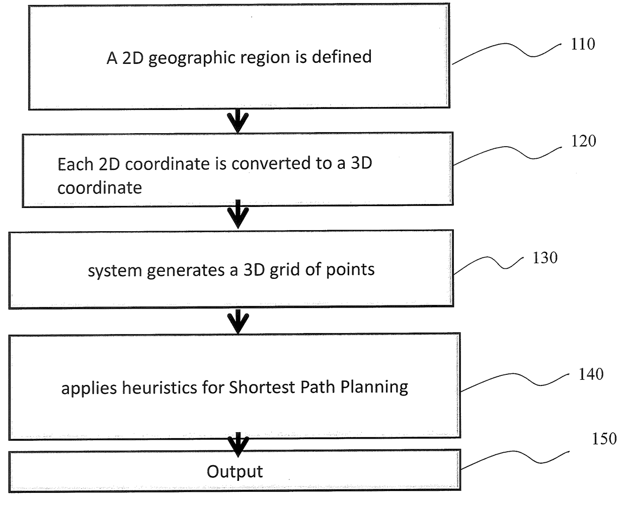
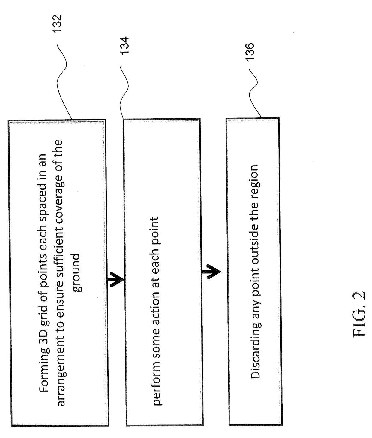
[0033]A system is provided to incorporate awareness of ground terrain, energy costs of various flight operations (increase / decrease ground elevation, change in direction, etc.), and current weather / wind conditions to generate optimal or near-optimal flight plans with 100% ground coverage. One of the objects is to maximize battery life by creating flight plans that take advantage of the underlying terrain model, paying attention to the energy-cost functions for drone flight operations (including for example, ascend / descend, he...


PUM


Abstract

A method includes defining a two-dimensional geographic region by two-dimensional geographic coordinates to define the bounds of the region, converting each of the two-dimensional coordinates to three dimensional coordinates by way of a lookup stored in a computer readable medium, generating a three-dimensional grid of points, each spaced in an arrangement to encompass coverage of a predetermined ground area, and applying heuristics for a shortest path planning, relative to the three-dimensional grid of points.

Description

BACKGROUND OF THE INVENTION[0001]Field of the Invention[0002]The disclosed invention relates generally to a technique of optimized path planning, and more particularly, but not by way of limitation, relating to a system, apparatus and method for optimized path planning for UAVs (unmanned aerial vehicles) for the purpose of ground coverage.[0003]Description of the Related Art[0004]UAVs (Unmanned Aerial Vehicles) or drones are emerging as de facto imaging method for many applications including defense, surveillance, asset management. Surveillance and reconnaissance tasks are currently often performed using an airborne platform such as a UAV. The airborne platform can carry different sensors. EO / IR cameras can be used to view a certain area from above. To support the task from the sensor analyst, different image processing techniques can be applied on the data, both in real-time or for forensic applications. Additionally, such UAV's can carry weapons and other cargo for delivery.[0005]...

Claims


Application Information

Patent Timeline
Patent Type & Authority Applications(United States)
IPC IPC(8): G08G5/00B64D47/08G05D1/10G06T17/05B64C39/02
CPCG08G5/0034G06T17/05B64C2201/123G05D1/101B64D47/08B64C39/024G01C21/20G06Q10/047G08G5/0069G05D1/0005G05D1/0202B64U2101/30
Inventor BOLAND, GREGORY F.MA, YUMANWEILER, JUSTIN G.SIEMONSEN, KEVIN E.TOPKARA, UMUTVOGT, KATHERINEWEISZ, JUSTIN
Owner IBM CORP
Why Eureka
Try Eureka