Method and system for estimating uncertainty for offline map information aided enhanced portable navigation

a technology of offline map information and uncertainty estimation, which is applied in traffic control systems, navigation instruments, instruments, etc., can solve the problems of pdr still lacking robustness, pdr that only relies on motion sensors, and conventional strapdown inertial navigation systems that use low-cost inertial sensors

Active Publication Date: 2017-08-03
INVENSENSE
View PDF0 Cites 46 Cited by
  • Summary
  • Abstract
  • Description
  • Claims
  • Application Information

AI Technical Summary

Problems solved by technology

However, some mass market applications require seamless positioning capabilities in all kinds of environments such as malls, offices or underground parking lots.
In the absence of GNSS signals in indoor environments, the conventional strapdown Inertial Navigation System (SINS) that uses low cost inertial sensors, suffers significant performance degradation due to the accumulated sensor drifts and bias.
As such, positioning technologies relying solely on motion sensors may not satisfy all requirements for seamless indoor and outdoor navigation applications.
However, PDR still lacks robustness because of the accumulated heading error.
This shortcoming may cause a skewed path over time and produce position estimates that might not be consistent with the building layout.
Therefore, the resulting navigation trajectories may cross walls, floors or other obstacles.
While easy to implement, it is sensitive to the way the road network was digitized.
Although it is more efficient than point-to-point aided, it may be unstable in dense road networks.
Unfortunately, this approach is quite sensitive to outliers and often gives unexpected results as a result.
Therefore, topological map aided algorithms normally outperform algorithms relying only on geometric techniques.
However, the misidentification of a road link in previous epoch may have significant negative effects on the following map aided results.
This is because the construction of an error region at each epoch may lead to incorrect link identification when other road links are close to the link on which the user is travelling.
While this assumption may be sufficiently valid in many outdoor land vehicle navigation applications, a problem may be encountered in complex indoor environments, where the rooms, elevators, corridors and similar structures cannot be simplified as the aforementioned points, lines and curves.
Some researchers use particle filters with geometric constraint (walls, inaccessible areas) information from a building floor plan to improve the indoor positioning accuracy, however, a user can enter or exit rooms in a random way and simple geometric constraints are undesirable in these scenarios.
Furthermore, such techniques have not accommodated multi-floor situations.
Such approaches may not be sufficiently reliable, particularly when drift in the navigation solution occurs.
Furthermore, most of the existing map aided algorithms ignore the user motion status information.
Although the advanced algorithms such as fuzzy logics or particle filters have the potential to offer improved performance, they may not be generally suitable for real-time or causal applications due to the heavy computation burden.

Method used


Image

  • Method and system for estimating uncertainty for offline map information aided enhanced portable navigation
  • Method and system for estimating uncertainty for offline map information aided enhanced portable navigation
  • Method and system for estimating uncertainty for offline map information aided enhanced portable navigation

Examples


examples

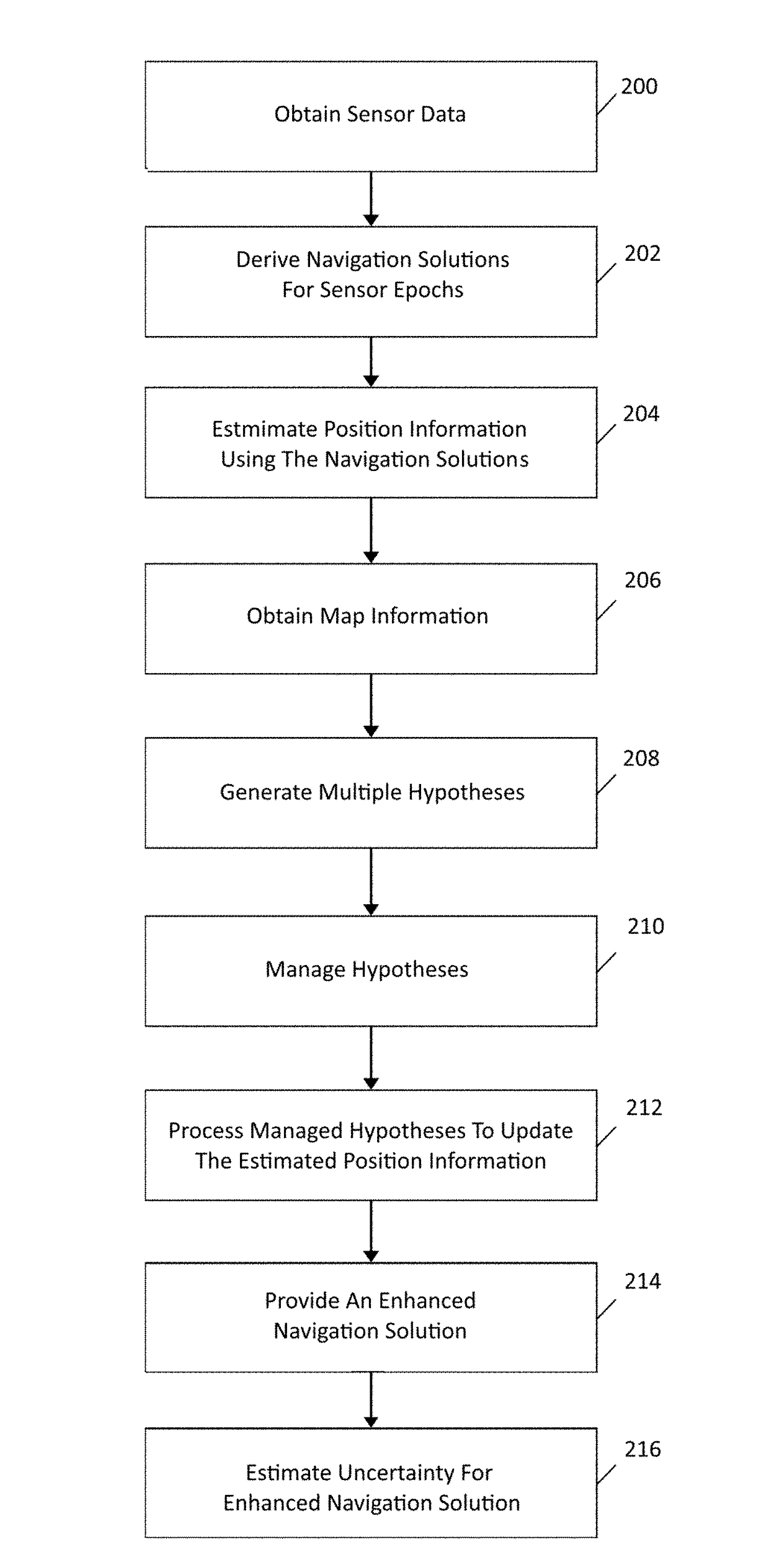
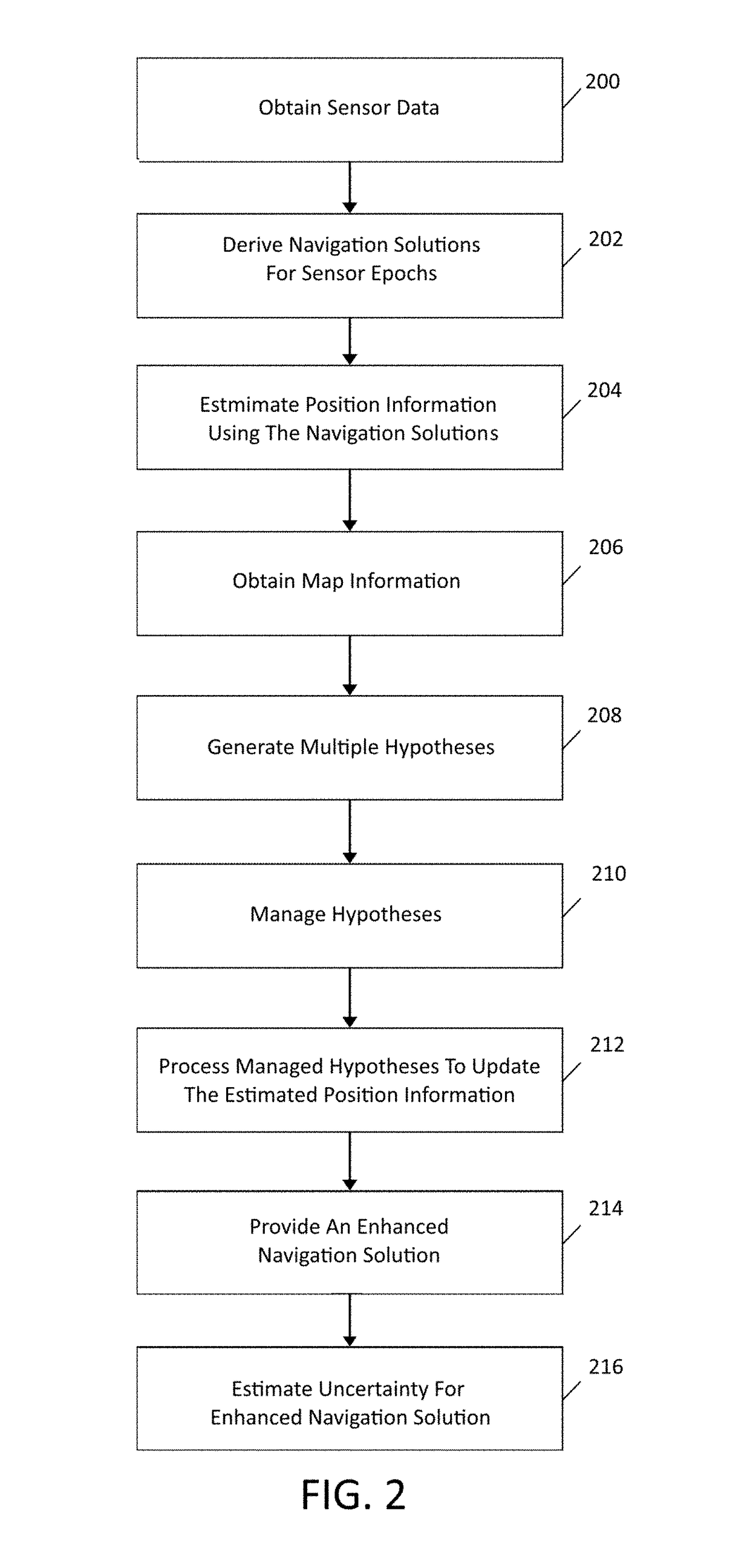
[0131]As described above, the techniques of the disclosure involve providing an offline enhanced navigation solution using map information. In some embodiments, operations and / or algorithms related to map matching may be similar to those described in co-pending, commonly-assigned U.S. patent application Ser. No. 14 / 845,903, filed Sep. 4, 2015, which is entitled “METHOD AND APPARATUS FOR USING MAP INFORMATION AIDED ENHANCED PORTABLE NAVIGATION,” which is related to causal map-matching as opposed to offline map-matching and is incorporated by reference in its entirety.

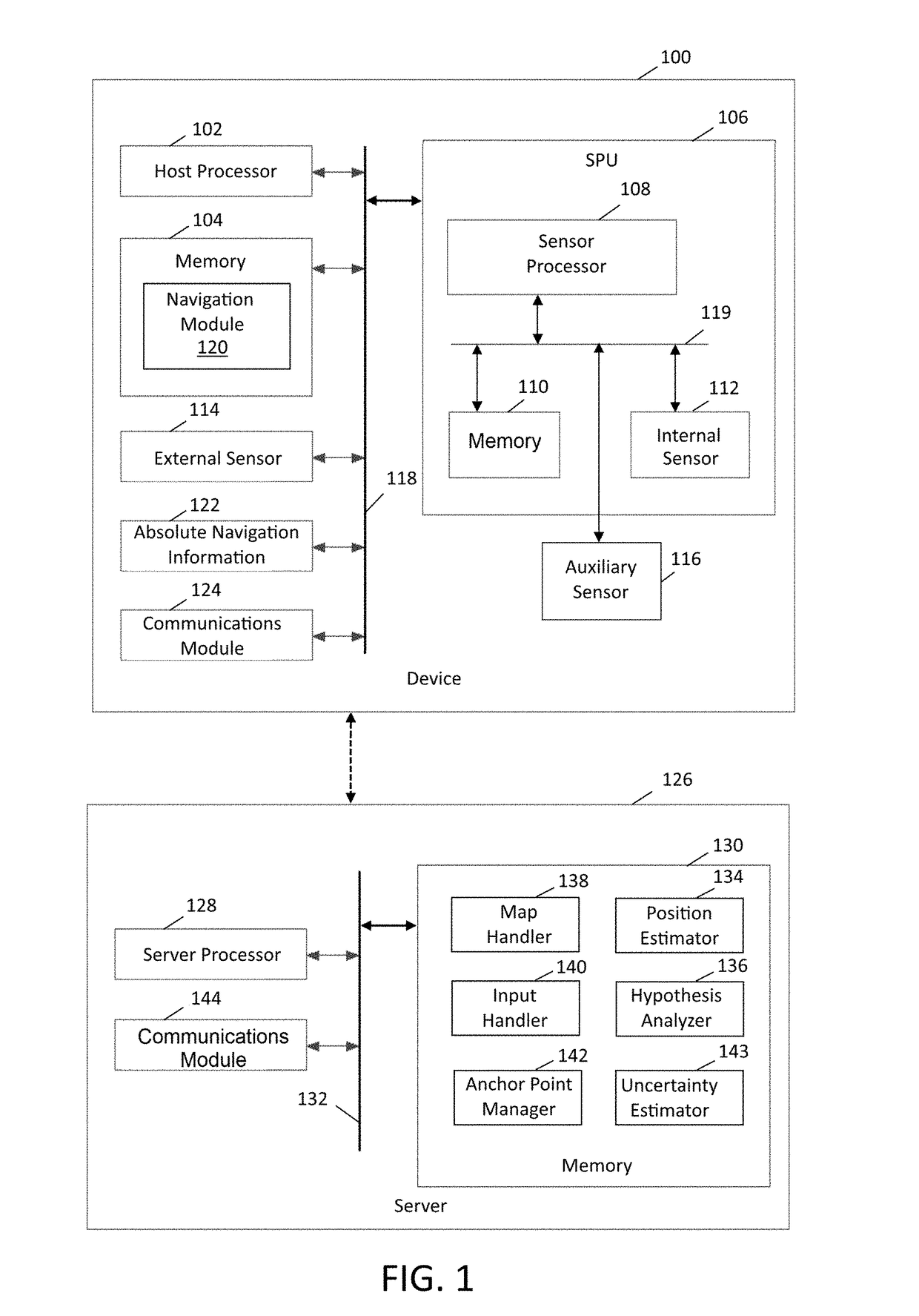
[0132]To illustrate an exemplary embodiment, one suitable relationship between the functional blocks implemented by server 126 is shown in FIG. 3. Navigation solutions derived by navigation module 120 corresponding to a plurality of sensor epochs over a first time period are fed to input hander 140 at subsequent time. Input handler 140 may provide operations on the navigation solutions to facilitate their use by position...


PUM


Abstract

The navigation solution of a portable device may be enhanced using map information. Sensor data for the portable device may be used to derive navigation solutions at a plurality of epochs over a first period of time. Position information for the device may be estimated at a time subsequent to the first period of time using the navigation solutions. Map information for an area encompassing a current location of the portable device may also be obtained. Multiple hypotheses regarding possible positions of the portable device may be generated using the estimated position information and the map information. By managing and processing the hypotheses, estimated position information for at least one epoch during the first period of time may be updated. An enhanced navigation solution for the at least one epoch may be provided using the updated estimated position information and an uncertainty measure may be derived for the enhanced navigation solution.

Description

CROSS REFERENCE TO RELATED APPLICATIONS[0001]This application is a continuation-in-part of U.S. patent application Ser. No. 14 / 976,992, filed Dec. 21, 2015, entitled “METHOD AND SYSTEM FOR USING OFFLINE MAP INFORMATION AIDED ENHANCED PORTABLE NAVIGATION,” which is assigned to the assignee hereof and is incorporated by reference in its entirety.FIELD OF THE PRESENT DISCLOSURE[0002]The present disclosure relates to a method and system for subsequently enhancing at least one navigation solution derived from sensor data for a device within a platform (such as for example person, vehicle, or vessel) through the use of map aided and / or map constraining to the navigation solution, wherein the device can be strapped or non-strapped to the platform, and wherein in case of non-strapped mobility of the device may be constrained or unconstrained within the platform, and wherein the device can be tilted to any orientation and still provide seamless navigation.BACKGROUND[0003]Portable electronic ...

Claims


Application Information

Patent Timeline
Patent Type & Authority Applications(United States)
IPC IPC(8): G01C21/30G01S19/42
CPCG01S19/42G01C21/30G01C21/206G01S19/49G01S5/0258G01S19/01
Inventor ELHOUSHI, MOSTAFAMAHMOUD, ANASMAO, SHENGLI, TAOGEORGY, JACQUES
Owner INVENSENSE
Why Eureka
Try Eureka