Crowdsourcing atmospheric correction data

a technology of atmospheric correction and crowdsourcing, applied in the field of global navigation satellite systems, can solve the problems of degrading the accuracy of overall position calculation, and the long time needed to obtain the desired accuracy, e.g., convergence tim

Active Publication Date: 2019-01-03
NOVATEL INC
View PDF5 Cites 23 Cited by
  • Summary
  • Abstract
  • Description
  • Claims
  • Application Information

AI Technical Summary

Benefits of technology

[0004]The inventive system and method crowdsources atmospheric data, from one or more rovers, that is utilized to account for ionospheric delay. Specifically, each rover, of one or more rovers, receives satellite signals from one or more global navigation satellite system (GNSS) satellites that are in view of the rover. The rover determines to what extent the signals received from a GNSS satellite are being adversely affected by atmospheric conditions, specifically, by ionospheric delay. Specifically, the rover calculates an estimated ionosphere delay value that indicates the adverse effect of ionospheric error on satellite signals transmitted

Problems solved by technology

These refractive effects cause errors in the observations (e.g., satellite range measurements) corresponding to the signals and result in a degrading of overall position calculation accuracy.
The corrections enable rover receivers to determine cm-level positioning, but the challenge is

Method used


Image

  • Crowdsourcing atmospheric correction data
  • Crowdsourcing atmospheric correction data
  • Crowdsourcing atmospheric correction data

Examples


Embodiment Construction

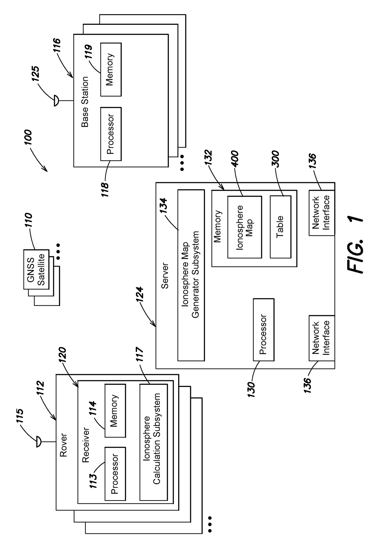
[0015]Referring to FIG. 1, a system 100 includes one or more rovers 112, one or more base stations 116, and a central server 124. The rovers 112 and base stations 116 may operate as part of a real time kinematic (RTK) system and / or a Precise Point Positioning (PPP) system over a wired or wireless network (not shown) or satellite-based data delivery (not shown), as known by those skilled in the art.

[0016]The one or more base stations 116 are typically stationary, have known positions and essentially clear views of the sky. The base station 116 includes an antenna 125 that receives global navigation satellite system (GNSS) satellite signals from one or more GNSS satellites 110 in view of the base station 116. In addition, the base station 116 includes one or more processors 118 and a memory 119. The one or more processors 118 may operate in a known manner to acquire and track the GNSS satellite signals, make raw observations (e.g., carrier and code-phase (pseudorange) observations), a...


PUM


Abstract

A system and method crowdsources atmospheric data from one or more rovers. The rovers calculate an estimated ionosphere delay value that indicates an adverse effect of ionospheric activity on signals received from the GNSS satellite. The values and identifiers may be transmitted to a server. The server utilizes the received information to generate an ionosphere map that reflects the magnitude of ionospheric delay at different locations. The ionosphere map is transmitted to one or more rovers. The rover determines if a pierce point associated with a selected GNSS satellite in view of the rover falls within the boundaries of the ionosphere map. If so, a corresponding ionosphere delay value is obtained utilizing the ionosphere map and then applied as a correction to account for ionospheric activity. In addition, the central server and/or rover may transmit the estimated ionosphere delay values and identifiers to other rovers.

Description

BACKGROUNDTechnical Field[0001]The invention relates generally to global navigation satellite systems (GNSS), and in particular, to a system that crowdsources atmospheric data from one or more rovers.Background Information[0002]The ionosphere is a layer of the Earth's atmosphere that is ionized by solar and / or cosmic radiation and typically lies 75-1,000 km (46-621 miles) above the Earth's surface. Specifically, global navigation satellite system (GNSS) satellite signals interact with free electrons along the propagation path through the ionosphere leading to a group delay and phase advance proportional to the Total Electron Content (TEC). These refractive effects cause errors in the observations (e.g., satellite range measurements) corresponding to the signals and result in a degrading of overall position calculation accuracy.[0003]Precise Point Positioning (PPP) is a method that enables worldwide centimeter (cm)-level positioning. Typically, a sparse global network of base station...

Claims


Application Information

Patent Timeline
IPC IPC(8): G01S19/07G01S19/04
CPCG01S19/07G01S19/44G01S19/04G01S19/072
Inventor JOKINEN, ALTTI
Owner NOVATEL INC
Why Eureka
Try Eureka