System and method for generating a phase scintillation map utilized for de-weighting observations from GNSS satellites

a technology of phase scintillation and satellites, applied in the field of global navigation satellite systems, can solve problems such as cycle slippage, degradation of overall positioning accuracy, and loss of lock at gnss receivers

Active Publication Date: 2019-02-21
NOVATEL INC
View PDF0 Cites 8 Cited by
  • Summary
  • Abstract
  • Description
  • Claims
  • Application Information

AI Technical Summary

Benefits of technology

[0004]The inventive system and method generates a phase scintillation map that is utilized for de-weighting satellite signal observations. Specifically, each base station receives satellite signals from one or more global navigation satellite systems (GNSS) satellites that are in view of the base station. The base station determines to what extent the signals received from a GNSS satellite are being adversely affected by atmospheric conditions, specifically, by ionospheric scintillation. For example, the base station may assign an index value to a GNSS satellite indicative of the adverse effect of ionospheric scintil

Problems solved by technology

Specifically, global navigation satellite system (GNSS) satellite signals interact with free electrons along the propagation path through the scintillation bubble causing phase errors, rapid phase fluctuations and/or signal power fading in the received signals, which may r

Method used


Image

  • System and method for generating a phase scintillation map utilized for de-weighting observations from GNSS satellites
  • System and method for generating a phase scintillation map utilized for de-weighting observations from GNSS satellites
  • System and method for generating a phase scintillation map utilized for de-weighting observations from GNSS satellites

Examples


Embodiment Construction

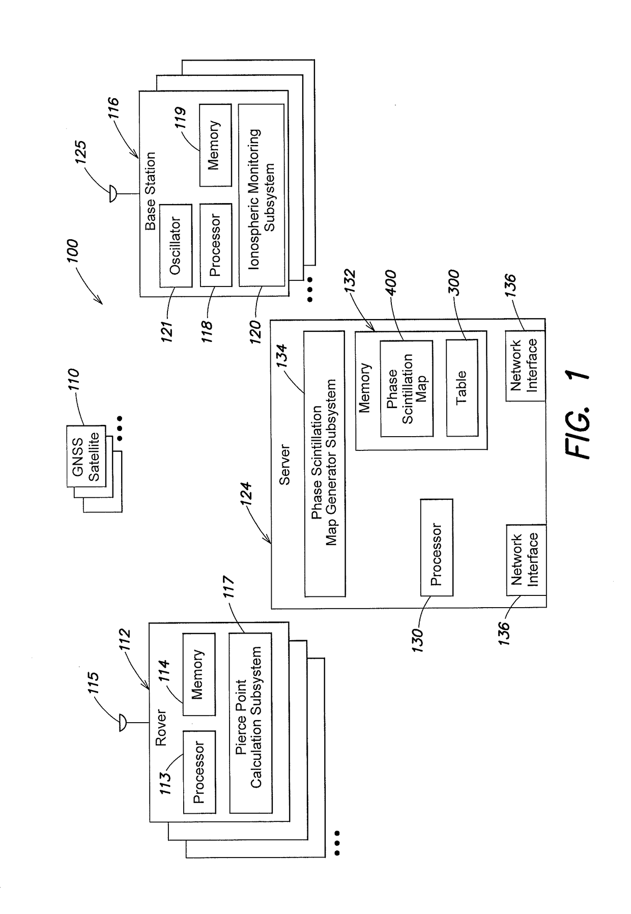
[0014]Referring to FIG. 1, a system 100 includes one or more rovers 112, one or more base stations 116, and a central server 124. The rovers 112 and base stations 116 may operate as part of a real time kinematic (RTK) system and / or a Precise Point Positioning (PPP) system over a wired or wireless network (not shown), as known by those skilled in the art.

[0015]The one or more base stations 116 are typically stationary, have known positions and essentially clear views of the sky. Each base station 116 includes an antenna 125 that receives global navigation satellite system (GNSS) satellite signals from one or more GNSS satellites 110 in view of the base station 116. In addition, the base station 116 includes one or more processors 118, a memory 119, and an oscillator 121, such as an Ovenized Crystal Oscillator (OXCO). It is noted that although oscillator 121 is depicted as being a separate component within the base station 116, it is expressly contemplated that the oscillator 121 may ...


PUM


Abstract

A system and method generates a phase scintillation map that is utilized to de-weight satellite signal observations from GNSS satellites. One or more base stations each assign an index value to one or more GNSS satellite in view, where the index value indicates an adverse effect of ionospheric scintillation on signals received from the GNSS satellite. The values and identifiers may be transmitted to a server. The server utilizes the received information to generate the phase scintillation map that may include one or more scintillation bubbles, wherein a location of each scintillation bubble is based on the received information. The phase scintillation map is transmitted to one or more rovers. The rover determines if a pierce point associated with a selected GNSS satellite in view of the rover falls within the boundaries of a scintillation bubble. If so, satellite signal observations from the selected GNSS satellite are de-weighted.

Description

BACKGROUNDTechnical Field[0001]The invention relates generally to global navigation satellite systems (GNSS), and in particular, to a system that generates a phase scintillation map that is utilized for de-weighting satellite signal observations from GNSS satellites.Background Information[0002]The ionosphere is a layer of the Earth's atmosphere that is ionized by solar and cosmic radiation and typically lies 75-1000 km (46-621 miles) above the Earth's surface. Particular portions or regions of the ionosphere, known as scintillation bubbles, are susceptible to ionospheric scintillation which causes radio-frequency signals passing through the scintillation bubble to experience rapid fluctuations in phase and / or amplitude. Specifically, global navigation satellite system (GNSS) satellite signals interact with free electrons along the propagation path through the scintillation bubble causing phase errors, rapid phase fluctuations and / or signal power fading in the received signals, which...

Claims


Application Information

Patent Timeline
IPC IPC(8): G01S19/04G01S19/43G01S19/07G01S19/05G01S19/08
CPCG01S19/04G01S19/43G01S19/08G01S19/05G01S19/07G01S19/28G01S19/072
Inventor MORLEY, THOMAS
Owner NOVATEL INC
Why Eureka
Try Eureka