Automatic localization geometry generator for stripe-shaped objects

a technology of automatic localization and geometry, applied in the direction of vehicle position/course/altitude control, process and machine control, instruments, etc., can solve the problems of high cost and turnaround optimization of conventional map coding procedures, a huge amount of manual labeling work in conventional techniques, and a large amount of resource-intensive map building procedures

Active Publication Date: 2019-05-23
HERE GLOBAL BV
View PDF3 Cites 33 Cited by
  • Summary
  • Abstract
  • Description
  • Claims
  • Application Information

AI Technical Summary

Benefits of technology

[0004]In an embodiment, a method for automatic localization geometry generation for stripe-shaped objects includes identifying an image including a roadway having one or more stripe-shaped objects, determining, using a processor, at least one targeted region within the image, wherein the at least one targeted region is shaped to intersect the one or more stripe-shaped objects and overlaps a plurality of pixels in the image, and performing, using the processor, an image analysis on the image to determine when the at least one target region having the plurality of pixels includes a pixel in common with the one or more stripe-shaped objects.
[0005]In an embodiment, an apparatus for automatic localization geometry generation for stripe-shaped objects includes a database and a localization geometry generator. The database is configured to store an image including a roadway having one or more stripe-shaped objects. The localization geometry generator is configured to determine at least one targeted region within the image, wherein the at least one targeted region is shaped to intersect the one or more stripe-shaped objects and includes a plurality of pixels and configured to perform ...

Problems solved by technology

Conventional procedures for map building are resource intensive.
For these high definition map applications, conventional map coding procedures are neither cost efficient nor turnaround optimized.
Conventional techniques require a massive amount of manual labeling work in high definition map building, especially localizing the stripe-shaped objects (e.g., lane/road boundaries, barrier/guardrail) in limited access roads.
The LiDAR only systems are highly susceptible to calibration errors in the LiDAR intensities.
When the LiDAR intensity is not well calibrated (or simply high intensity points are mostly coming from grass ...

Method used


Image

  • Automatic localization geometry generator for stripe-shaped objects
  • Automatic localization geometry generator for stripe-shaped objects
  • Automatic localization geometry generator for stripe-shaped objects

Examples


embodiment 1

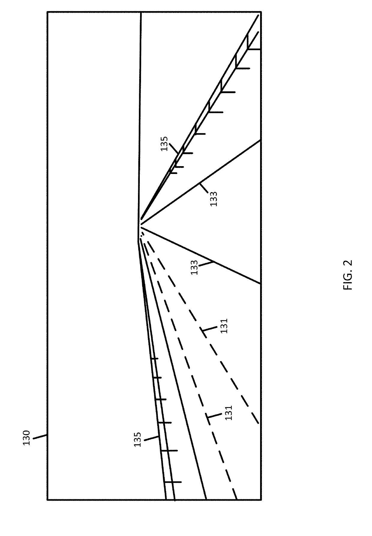
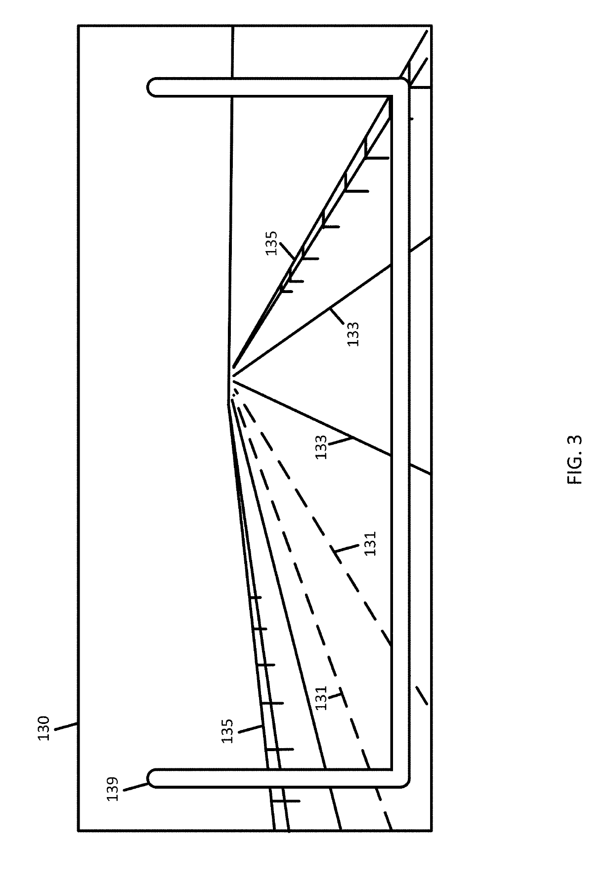
[0190]A method for automatic localization geometry generation for stripe-shaped objects, the method comprising:[0191]identifying an image including a roadway having one or more stripe-shaped objects;[0192]determining, using a processor, at least one targeted region within the image, wherein the at least one targeted region is shaped to intersect the one or more stripe-shaped objects and overlaps a plurality of pixels in the image; and[0193]performing, using the processor, an image analysis on the image to determine when the at least one target region having the plurality of pixels includes a pixel in common with the one or more stripe-shaped objects.

embodiment 2

[0194]The method of embodiment 1, wherein the at least one targeted region includes a plurality of targeted regions spaced apart by a predetermined distance.

embodiment 3

[0195]The method of any of embodiments 1 and 2, wherein the at least one targeted region is U-shaped.


PUM


Abstract

Apparatus and methods are described for generating geometries for stripe-shaped objects. An image is identified that includes a roadway having one or more stripe-shaped objects. The stripe-shaped objects may include lane lines for road edges or lanes of the roadway. The stripe-shaped objects may include a barrier. At least one targeted region within the image is determined. The at least one targeted region is shaped to intersect the one or more stripe-shaped objects and includes a plurality of pixels. An image analysis is performed on the image to determine when the at least one target region includes a pixel in common with the one or more stripe-shaped objects. A geometry is constructed using the pixel in common. The geometry may be used to update a map or subsequently perform localization.

Description

FIELD[0001]The following disclosure relates to detection of stripe-shaped objects, map updates based on the detected stripe-shaped objects, automatic localization geometry based on the detected stripe-shaped objects, and navigation systems and / or driving assistance systems based on the automatic localization geometry.BACKGROUND[0002]Map databases may be used to provide navigation based features such as routing instructions for an optimum route from an original location to a destination location and map based features such as section and display of maps to manually locate locations or points of interest. Map databases are used in driver assistance systems or driverless systems, or autonomous driving systems.[0003]Conventional procedures for map building are resource intensive. It requires human operators as map coders to manually pinpoint control points (e.g., vertices of polylines) to accurately localize every relevant map objects on or near road surfaces. The amount of human input ...

Claims


Application Information

Patent Timeline
IPC IPC(8): G06K9/00G06K9/46G06K9/62G08G1/16G05D1/02G06V10/764
CPCG06K9/00798G06K9/4609G06K9/6256G08G1/167G05D1/0212G01C21/34G05D2201/0213G06V20/588G06V10/82G06V10/764G06F18/214G06F18/24143
Inventor ZHANG, QILINMA, XIANGCHEN, XINSOOD, SANJAYTABB, MARKLUO, CHEN
Owner HERE GLOBAL BV
Why Eureka
Try Eureka