Method of assisting detection of man-made structures in a digital elevation map (DEM)

a technology of digital elevation map and man-made structure, applied in wave based measurement system, reradiation, instruments, etc., can solve the problems of insufficient approach, method does not make it possible to isolate buildings, drawbacks of such an approach, etc., and achieve the effect of reducing the various inadequacies

Inactive Publication Date: 2000-08-15
ALCATEL LUCENT SAS
View PDF2 Cites 21 Cited by
  • Summary
  • Abstract
  • Description
  • Claims
  • Application Information

AI Technical Summary

Benefits of technology

An object of the invention is to provide a method mitigating the various inadequacies. More precisely, the method of the invention makes it possible to detect a region even if it contains only one man-made structure, and to determine the shape and optionally the height of a building detected in this way. Such regions are referred to below as Regions Of Interest (ROIs).

Problems solved by technology

But the drawbacks of such an approach quickly become apparent:
That method does not make it possible to isolate the buildings and can only show up zones.
For application to cellular network planning, such an approach is inadequate.
Finally, the method gives no indication about the heights of the buildings or their shapes.

Method used


Image

  • Method of assisting detection of man-made structures in a digital elevation map (DEM)
  • Method of assisting detection of man-made structures in a digital elevation map (DEM)
  • Method of assisting detection of man-made structures in a digital elevation map (DEM)

Examples


Embodiment Construction

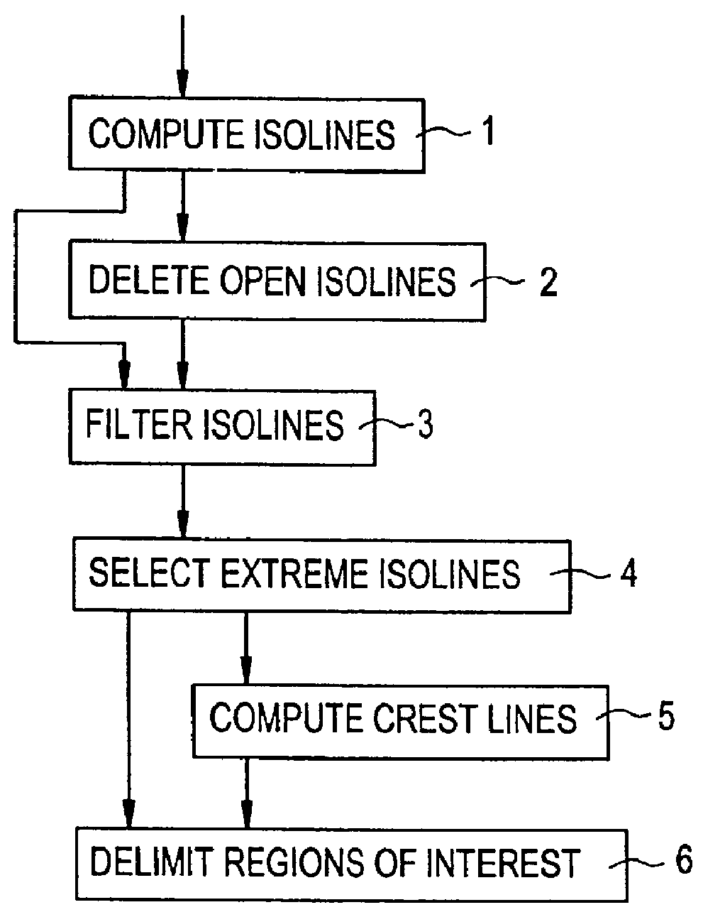
FIG. 1 is a flow chart showing the general structure of the method.

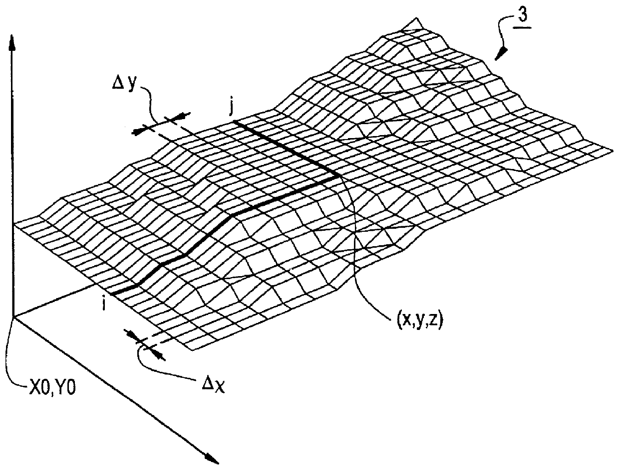
The data processed by the algorithm is constituted by digital elevation maps, an example of such a map being shown in FIG. 2.

A Digital Elevation Map (DEM) is a well known concept in three-dimensional (3D) imaging. It is a sampled matrix representation of a terrain, in which representation each co-ordinate point i,j is caused to correspond to a height h(i,j).

The relationships between the co-ordinates i and j in the digital elevation map and the co-ordinates x, y, and z in the real 3D world are given by the following:

x=X.sub.o +i.times..DELTA..sub.x

y=Y.sub.o +j.times..DELTA..sub.y

z=h(i,j)

where X.sub.o and Y.sub.o represent the co-ordinates of the origin of the digital elevation map, and .DELTA..sub.x and .DELTA..sub.y represent the real distances between two samples in those two directions on the terrain.

Reference 1 represents the step of computing isolines on the digital elevation map.

An isoline is defined as being a ...


PUM


Abstract

A method of detecting man-made structures in a digital representation of a terrain, wherein said representation is a digital elevation map, and wherein said method comprises the following steps: computing isolines in said digital elevation map; filtering said isolines on the basis of a size criterion; computing extremum isolines from the isolines filtered during the preceding step; and determining said regions of interest. The invention is applicable to any process involving supervision of a geographical site (e.g. planning cellular telecommunications networks).

Description

The present invention relates to a method of assisting detection of man-made structures in a Digital Elevation Map (DEM).The problem of detecting man-made structures in a computerized representation (image, digital elevation map, etc.) occurs in numerous applications, e.g. in planning cellular radiocommunications networks.Such a network, e.g. a GSM (Global System for Mobile communications) network includes a plurality of base stations distributed geographically. Each of the stations serves to offer radio coverage for a determined geographical zone referred to as a "cell".The geographical zone that any given base station actually covers depends on the geographical environment, and in particular on the presence of man-made structures in that environment. Thus, in order to locate the base stations in optimum manner, i.e. so that a mobile station is always able to communicate with a base station, it is necessary to know the positions of such man-made structures.Conventionally, such terr...

Claims


Application Information

Patent Timeline
Patent Type & Authority Patents(United States)
IPC IPC(8): G06K9/00
CPCG06K9/00G06F18/00
Inventor LOUIS, CHRISTIANLECHERVY, YVES
Owner ALCATEL LUCENT SAS
Why Eureka
Try Eureka