Hydrant monument

a technology of water towers and monuments, applied in the field of monuments, can solve the problems of difficult maintenance, low quality assurance, and difficult use of monuments for geodetic and other types of surveys,

Inactive Publication Date: 2005-04-05
HYDMON
View PDF19 Cites 6 Cited by
  • Summary
  • Abstract
  • Description
  • Claims
  • Application Information

AI Technical Summary

Benefits of technology

According to another aspect of the invention there is provided a computer program adapted for generating a visual representation of a section of terrain in the real world, said representation including indicators for a series of computer generated fire hydrants corresponding to fire hydrants in said section of terrain, said fire hydrants in said section of terrain having known co-ordinates for inputting into said computer program as location control points for said computer generated representation, whereby when said known co-ordinates corresponding to said series of fire hydrants in said section of terrain are inputted to said computer program as location control points for said computer program will generate a representation having all features shown in the representation in their true relative positions.
According to another aspect of the invention there is provided a computer program for generating a map or model having a plurality of location control points corresponding to fire hydrants in the real world, each of said fire hydrants having co-ordinates in the real world stored in said computer program.

Problems solved by technology

GPS surveys make this survey more economically viable but offer no quality assurance without being integrated or tied into physical monuments the location of which are known.
However, the monuments used for geodetic and other types of surveys are expensive to place, difficult to maintain and not easily used for many practical survey applications.
This makes them difficult and expensive to install and / or use.
It will be appreciated, however, that these types of monuments can be time consuming and costly to manufacture and locate, particularly when several are needed to be located within a given area.
However, it is sometimes difficult to insert or affix these known monuments in places where they are needed.
The vast majority are removed during construction and this can result in disputes over property lines and involve having to perform retracement surveys.
Particularly in cold climates where there is a lot of snow and ice on the ground, this may make the locating of a monument by a surveyor particularly difficult, requiring digging through snow and ice to try to find the monument.
Being positioned flush or almost flush to the ground poses other problems, including the greater risk of being dislodged, displaced or vandalised.
However, it is relatively difficult for the general public to know where to look for such a monument, when they decide they need to calibrate or localize their GPS device or other electronic location device to obtain a quality assurance reading.

Method used


Image

  • Hydrant monument
  • Hydrant monument
  • Hydrant monument

Examples


Embodiment Construction

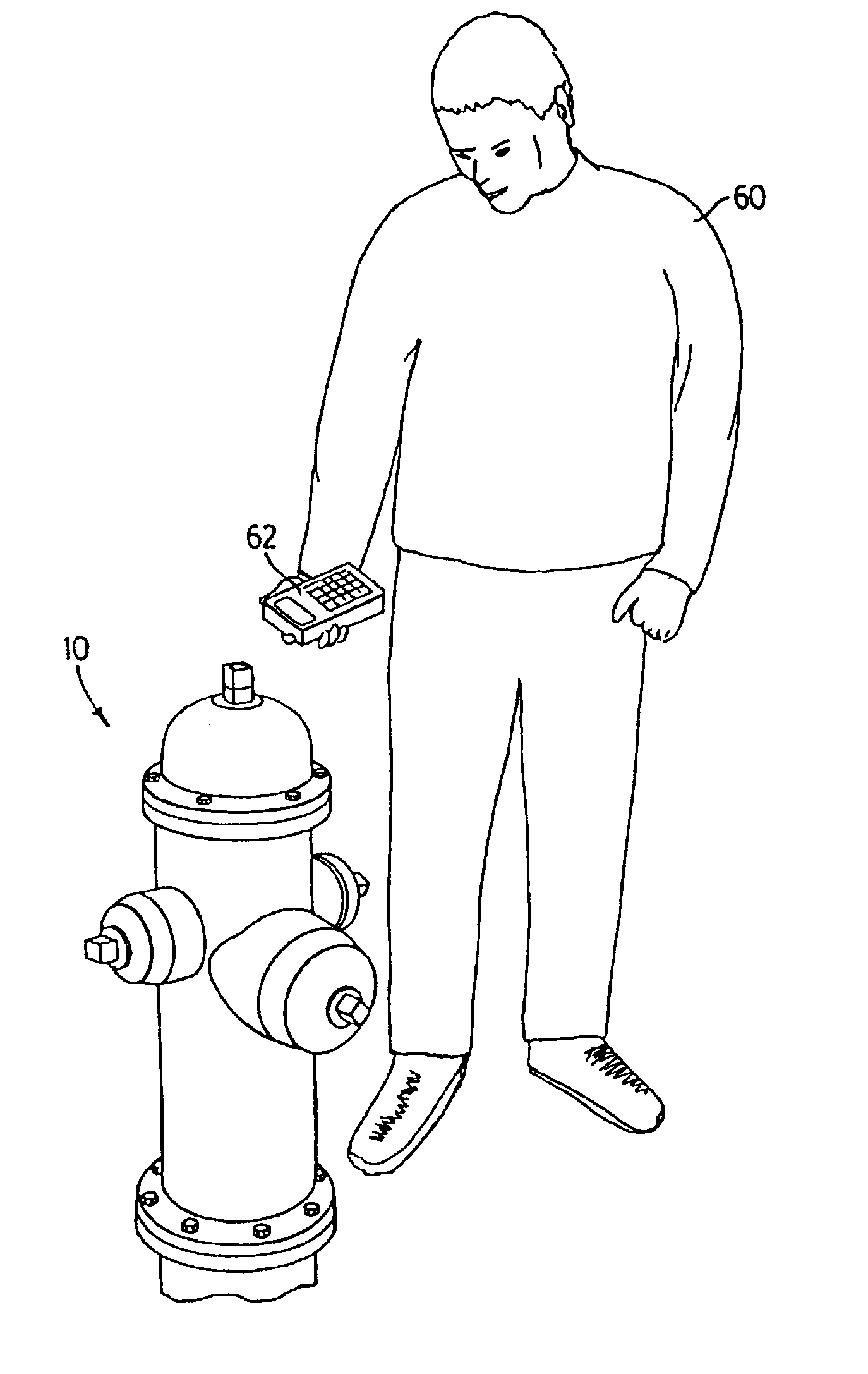
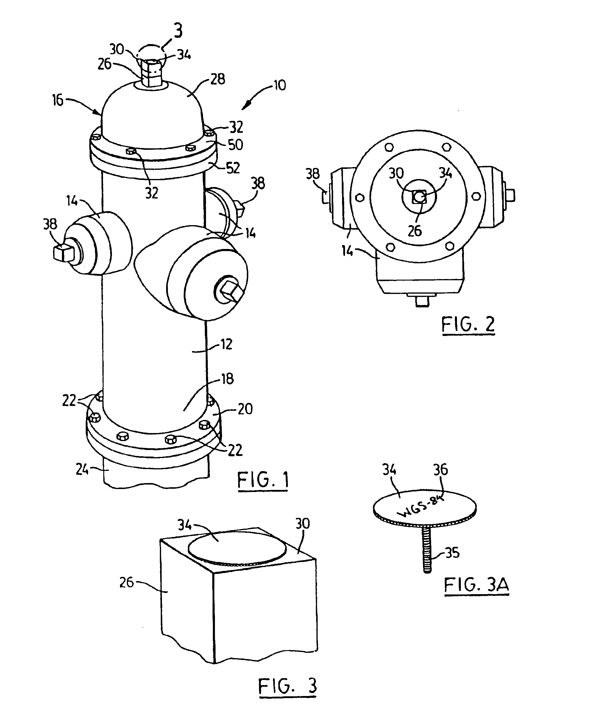
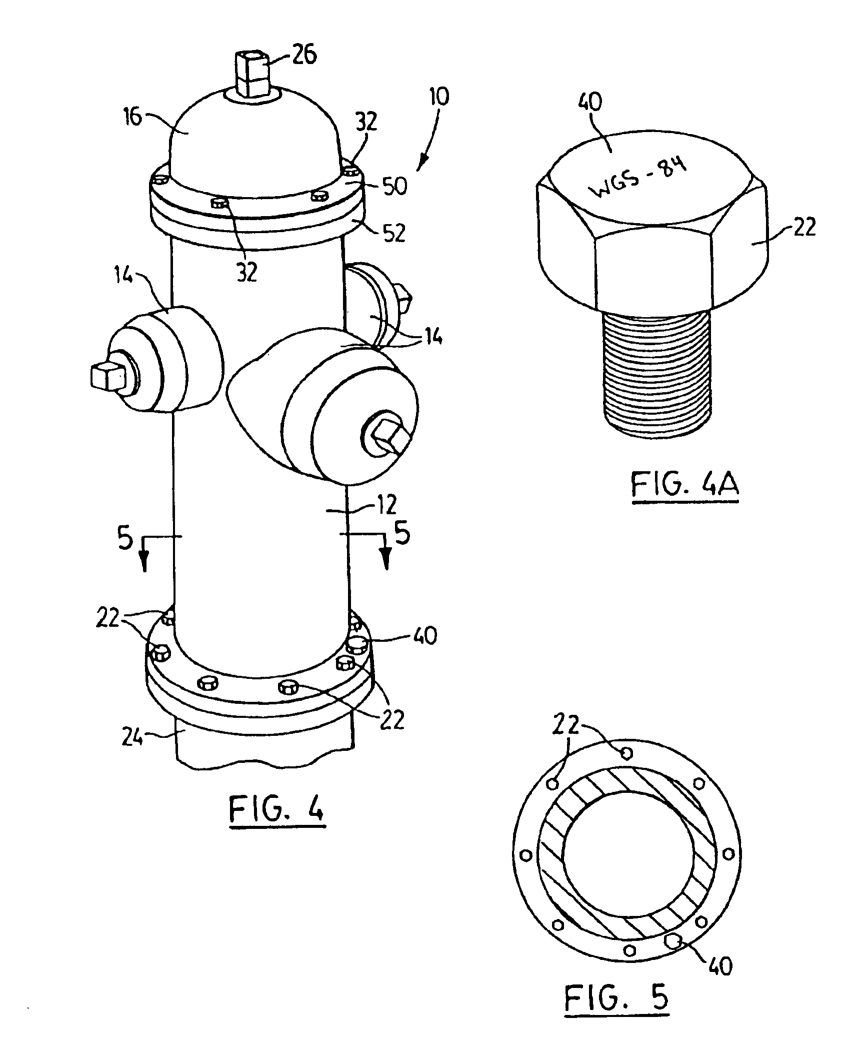
With reference to FIGS. 1, 2, 3 and 3A, a hydrant monument in accordance with a preferred embodiment of the invention is illustrated and generally designated 10. The hydrant monument 10 comprises a conventional water hydrant, such as a fire hydrant. As is known, fire hydrants are provided in most, if not all areas where there is an established municipal or community water system. Fire hydrants are typically spread throughout the community at spaced but not infrequent intervals, and are interconnected to the community's water mains. Fire hydrants are generally located in highly visible locations and there are typically legal restrictions prohibiting the interference therewith (e.g. parking restrictions in the vicinity of a fire hydrant). Fire hydrant 10 in the preferred embodiment disclosed herein, is preferably coloured, at least partly, in a bright or otherwise noticeable colour such as red, yellow or orange to make it more easily visible. Monument hydrant 10 may be representative ...


PUM


Abstract

A survey monument comprises a conventional water hydrant with survey indicia or markings attached thereto. The survey indicia can be carried for example on a plate mounted on a flange bolt or attached to the operating nut of the hydrant. These survey monuments can be expanded upon and/or maintained in co-ordination with the expansion and maintenance of a municipality's water supply system. The hydrants can also be utilized in connection with any geographical information system to provide known reference points. The hydrants can also be utilized in connection with GPS devices to assist in localizing, initializing and calibrating the same.

Description

FIELD OF THE INVENTIONThe present invention relates to monuments, including those used by surveyors, and to monuments or reference points that can be used in connection with, but not limited to, electronic positioning systems, such as Total Station Survey Systems, Global Positioning Systems (GPS) and Geographical Information Systems (GIS). The invention also relates generally to any form of geographical information system.BACKGROUND OF THE INVENTIONThere are several different types of surveys. For example, geodetic surveys cover a large geographic area and attempt to define the exact three-dimensional coordinates (northing, easting and elevation) of points on the earth's surface. Cadastral surveys are typically boundary surveys to define legal or political boundaries on plans.Another type of survey is associated with a GIS (“Geographical Information System”), which ties assets to spatial data, and these are best derived from a universally acceptable coordinate system such as the GPS...

Claims


Application Information

Patent Timeline
Patent Type & Authority Patents(United States)
IPC IPC(8): E03B9/00E03B9/02G01C15/04G01C15/02G01S5/14G01S1/00G01S19/23
CPCE03B9/02G01S19/23G01C15/04Y10T137/5327
Inventor CLINE, DARRELL G. B.
Owner HYDMON
Why Eureka
Try Eureka