Method and apparatus for the display of temporal distance data

a technology of temporal distance and data, applied in the direction of instruments, surveying and navigation, navigation instruments, etc., can solve the problems of inability to translate the information in travel time and difficulty in planning stops in advan

Active Publication Date: 2005-08-23
QUALCOMM INC
View PDF3 Cites 97 Cited by
  • Summary
  • Abstract
  • Description
  • Claims
  • Application Information

AI Technical Summary

Problems solved by technology

When planning travels, it is difficult to plan stops in advance since so many parameters affecting speed are unavailable on a standard map or global positioning system (GPS) device.
Current maps and GPS devices are very good at calculating distances and showing elevations, but are incapable of translating that information into travel time.

Method used


Image

  • Method and apparatus for the display of temporal distance data
  • Method and apparatus for the display of temporal distance data
  • Method and apparatus for the display of temporal distance data

Examples


Embodiment Construction

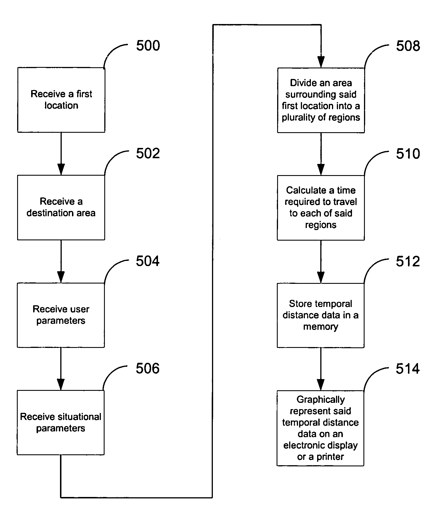
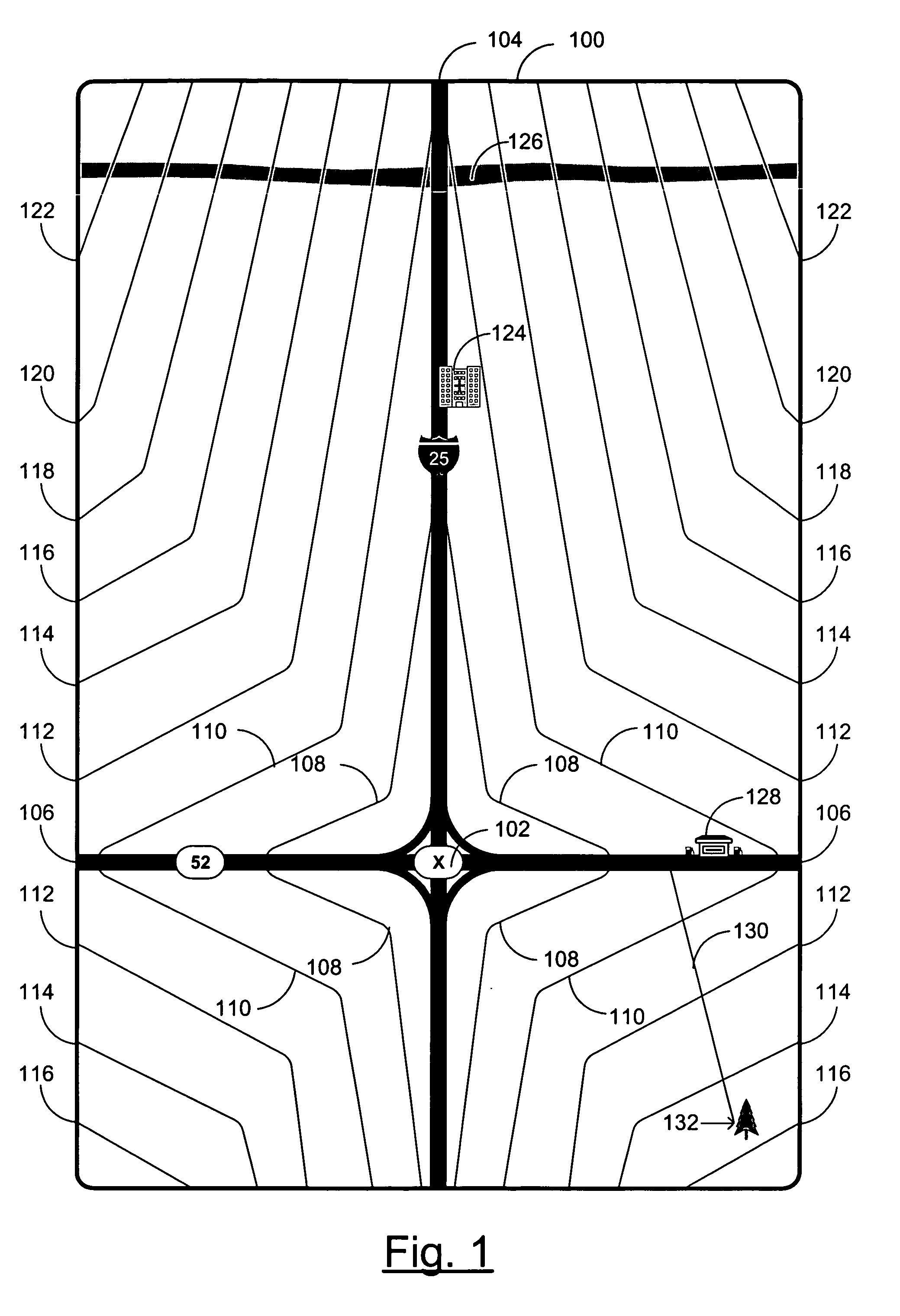
[0010]FIG. 1 is an example of a display output of temporal distance data according to the present invention. In this example embodiment of the present invention an electronic display 100 is configured to graphically represent temporal distance data within a destination area. The temporal distance data is represented by a set of temporal contour lines 108, 110, 112, 114, 116, 118, 120, and 122 each of which represents a distance the user can travel in a give time. For example, the first contour line 108 may represent all the locations that the user can travel to in five minutes, while the second contour line 110 may represent all the locations that the user can travel to in ten minutes, with the remaining contour lines similarly having a spacing of five minutes. In this example, an interstate highway 104 runs top to bottom on the display screen 100, and a state highway 106 runs left to right on the display screen 100. Note, that the orientation of the screen with respect to the direc...


PUM


Abstract

An electronic device is built including a memory, a processor, and a display. The processor is configured to calculate an array of estimated travel time data from a first location to a plurality of locations within a destination area from a set of situational parameters and a set of user parameters. These situational parameters may include data such as: the location, condition, and speed limits of roads and paths; the availability of public transportation; terrain information such as elevation, slope, the presence of trails and vegetation; and weather information such as wind speed and precipitation. User parameters may include data such as: the user's mode of transportation, the user's physical abilities, and the load the user is carrying.

Description

FIELD OF THE INVENTION[0001]The present invention relates generally to the field of calculation and graphical display of data and more particularly to the calculation and graphical display of temporal data from distances.BACKGROUND OF THE INVENTION[0002]When traveling, one generally doesn't care as much about the distance to a destination as much as the time it takes to get there. When planning travels, it is difficult to plan stops in advance since so many parameters affecting speed are unavailable on a standard map or global positioning system (GPS) device. In a wilderness situation, it may be critical to know if a road or help can be reached before sunset. It may be better to spend remaining daylight hours building shelter for the night instead of pushing on to unreachable help. Current maps and GPS devices are very good at calculating distances and showing elevations, but are incapable of translating that information into travel time.SUMMARY OF THE INVENTION[0003]An electronic d...

Claims


Application Information

Patent Timeline
Patent Type & Authority Patents(United States)
IPC IPC(8): G08G1/123G08G1/01G08G1/127
CPCG08G1/0104G08G1/127G08G1/202
Inventor GEHMAN, LES
Owner QUALCOMM INC
Why Eureka
Try Eureka