Navigation assistance method and system

a technology of navigation assistance and navigation, applied in navigation instruments, surveying and navigation, instruments, etc., can solve the problems that boat users, however, have not been privy to such a servi

Inactive Publication Date: 2007-04-24
NAVQUEST
View PDF2 Cites 56 Cited by
  • Summary
  • Abstract
  • Description
  • Claims
  • Application Information

AI Technical Summary

Benefits of technology

[0004]A related general object of the present invention is to provide such a method and / or system that assists the waterway traveler in determining a marine or over-water route between a trip start point and a trip end point.
[0010]Generally, the recommended route is communicated to the user in the form of a map that is displayed on the user's computer monitor. The route may include latitude and longitude coordinates that define trip leg termini and waypoints. Alternatively, a route may be completely specified by multiple latitude and longitude coordinate pairs. In addition, course-change angles or compass bearings may be included in the route information for assisting the user in making course changes at waypoints while en route, whereby the user moves from one leg to another leg of the route.

Problems solved by technology

Boat users, however, have not been privy to such a service.

Method used


Image

  • Navigation assistance method and system
  • Navigation assistance method and system
  • Navigation assistance method and system

Examples


Embodiment Construction

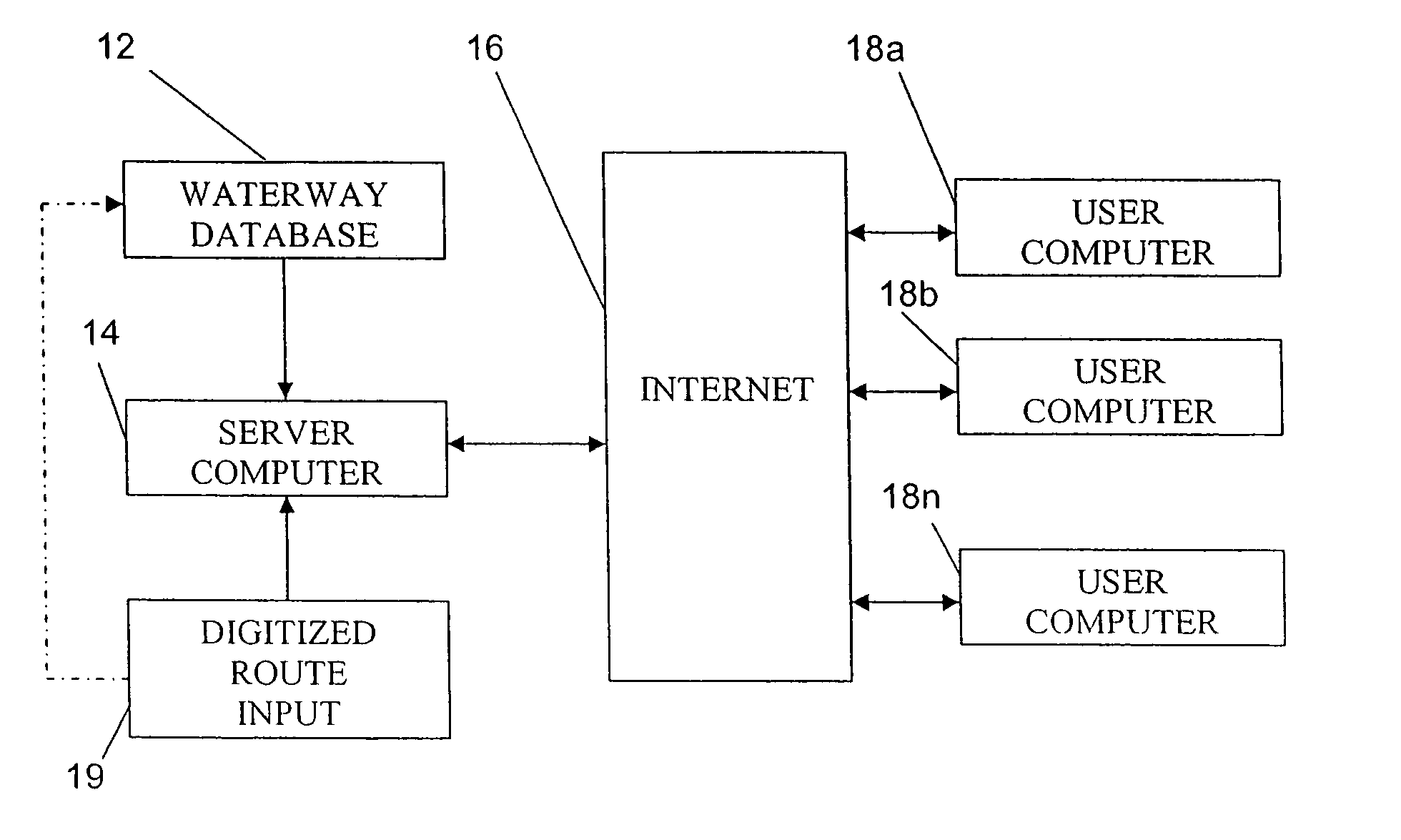
[0048]FIG. 1 depicts a navigation assistance system comprises a database 12 and a server computer 14 connected to the global computer network known as the Internet 16 for providing recommended marine or waterway routes to users that utilize the services of server computer 14 via respective personal computers 18a, 18b, . . . 18n. In general, server computer 14 derives or calculates the recommended routes and provides waterway maps and the recommended routes, as well as additional information, to user computers 18a, 18b, . . . 18n in response to requests from the user computers.

[0049]Database 12 stores waterway data that at least implicitly incorporates waterway depth information. The waterway depth information may be in the form of depth values at discrete latitude and longitude coordinates, for instance, at points of a grid. Alternatively, the depth information may take the form of depth contours.

[0050]In another type of waterway data formatting, database 12 may store predetermined ...


PUM


Abstract

In a navigation assistance system, information is received via the Internet from a user pertaining to a water trip contemplated by the user. The system includes a database storing waterway data. The database is accessed in response to the information from the user. At least one recommended over-water route is derived in response to the user information and in accordance with waterway data in the database, the recommended route being communicated to the user via the computer network. The deriving of the route preferably comprises including only route segments extending through operatively navigable areas.

Description

BACKGROUND OF THE INVENTION[0001]This invention relates to a method and an associated system for providing navigational assistance to marine wayfarers. More particularly, this invention relates to a method and associated system for assisting marine travelers in planning routes between trip start points and trip end points.[0002]Well-known services exist for providing automobile drivers, via the global computer network known as the Internet, with road maps and even recommended routes for travel over highways and roads from a start address to a destination address. Boat users, however, have not been privy to such a service. There is a need for such a service, namely, an Internet-mediated navigation assistance service that provides waterway travelers with marine maps and recommended routes between trip start points and trip end points.OBJECTS OF THE INVENTION[0003]It is a general object of the present invention to provide a method and / or a system for assisting waterway travelers in pla...

Claims


Application Information

Patent Timeline
Patent Type & Authority Patents(United States)
IPC IPC(8): G01C21/34
CPCG01C21/203
Inventor LITVACK, KENNETHSANGHA, HARPREET
Owner NAVQUEST
Why Eureka
Try Eureka