Integrated mapping and audio systems

a mapping and audio technology, applied in the field of mapping systems, can solve the problems of cumbersome or inconvenient taking the time to prepare journal entries, not always desirable, and limited data that can be provided by systems,

Active Publication Date: 2007-06-26
NAVICO HLDG
View PDF15 Cites 60 Cited by
  • Summary
  • Abstract
  • Description
  • Claims
  • Application Information

AI Technical Summary

Problems solved by technology

Accompanying logs, however, require carrying additional materials, which may not always be desirable when using these systems.
As described above, however, these systems are limited in the amount of data that can be provided.
While event logs may permit maintaining such data, they still require additional supplies, and it is often cumbersome or inconvenient to take the time to prepare journal entries to maintain such data.

Method used


Image

  • Integrated mapping and audio systems
  • Integrated mapping and audio systems
  • Integrated mapping and audio systems

Examples


Embodiment Construction

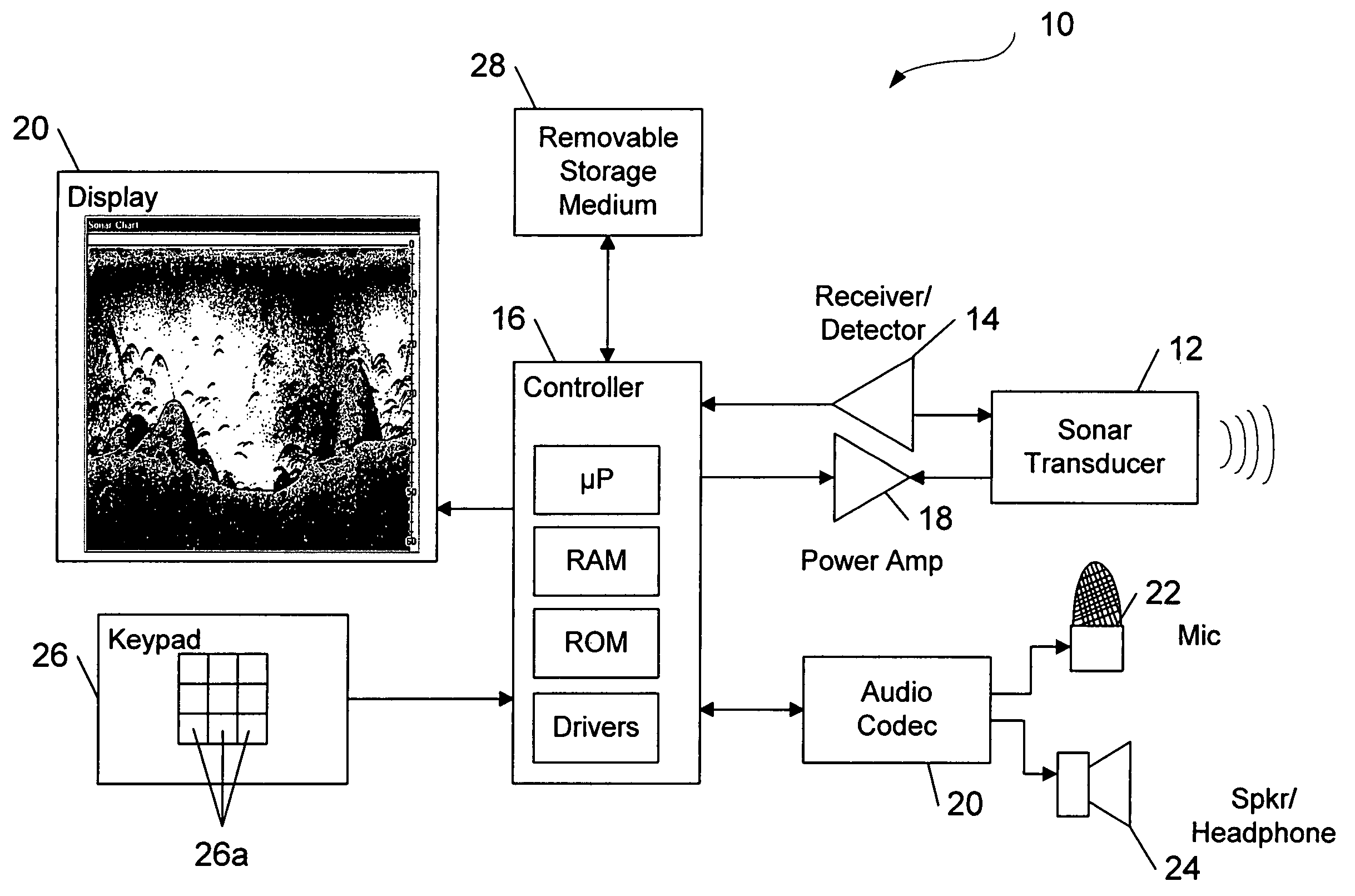
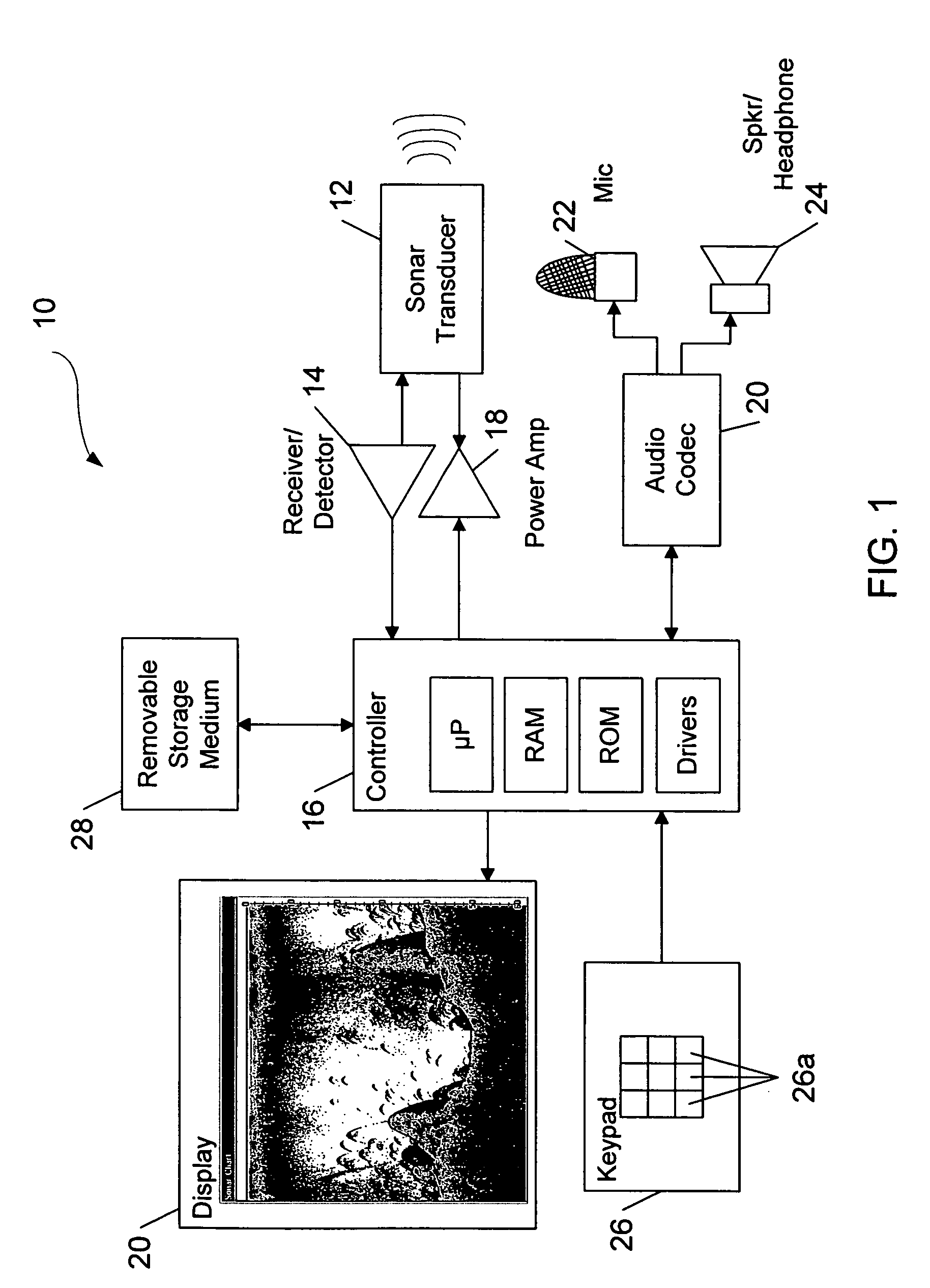
[0021]The present inventions now will be described more fully hereinafter with reference to the accompanying drawings, in which some, but not all embodiments of the inventions are shown. Indeed, these inventions may be embodied in many different forms and should not be construed as limited to the embodiments set forth herein; rather, these embodiments are provided so that this disclosure will satisfy applicable legal requirements. Like numbers refer to like elements throughout.

[0022]Referring now to FIG. 1, a block diagram of the integrated sonar mapping system 10 according to one embodiment of the present invention is shown. As illustrated in FIG. 1 and block 32 of FIG. 2, the integrated sonar and mapping system includes at least one transducer 12 for emitting sonar signals toward the bottom surface of a body of water. While the illustrated embodiment of the integrated sonar and mapping system includes only a single transducer, the integrated sonar and mapping system can include a ...


PUM


Abstract

An integrated position mapping system and an integrated sonar mapping system both permit recording, storage and playback of audio data. Audio data is provided to the integrated sonar mapping system or the integrated position mapping system so that it may be correlated to position data or echo data. The integrated sonar mapping system includes a sonar transducer for emitting and receiving sonar signals that may be subsequently be processed to provide echo data from objects in the water which reflect sonar signals. The integrated position mapping system includes a position receiver for providing position data. A controller not only processes the data for storage, but also correlates the audio data to echo data or position data. The correlated data may therefore be retrieved for playback of the audio data and display of the position data or echo data.

Description

FIELD OF THE INVENTION[0001]The present invention relates to mapping systems, such as position mapping and sonar mapping; and, more particularly, the invention relates to audio systems in sonar and position mapping systems that play audio data and record and store audio data.BACKGROUND OF THE INVENTION[0002]Mapping and navigation systems typically determine the relative position of a user based upon positioning signals received from one or more land-based beacons, one or more orbiting satellites comprising the Global Positioning System (“GPS”), or other sources. Based upon these positioning signals, the mapping and navigation system can determine other navigational data, such as the present latitude and longitude position and the present compass heading, course over ground, bearing and speed over ground. In addition, mapping and navigation systems allow the operator to enter several event markers to identify specific positions and several waypoints to mark a course which the operato...

Claims


Application Information

Patent Timeline
Patent Type & Authority Patents(United States)
IPC IPC(8): G01S15/89G01S19/48
CPCG01S15/025G01S15/89G01S15/96G01S15/86
Inventor TURNER, REXWEBER, RONALD G.
Owner NAVICO HLDG
Why Eureka
Try Eureka