Navigation and coordination during emergencies

a technology for emergency services and navigation, applied in the direction of individual entry/exit registers, burglar alarm mechanical actuation, instruments, etc., can solve the problems of difficulty in determining the location of emergency service providers, layout of buildings and may become disoriented, and difficulty for fire fighters to see clearly enough to distinguish building features

Inactive Publication Date: 2007-07-10
CISCO TECH INC
View PDF11 Cites 125 Cited by
  • Summary
  • Abstract
  • Description
  • Claims
  • Application Information

AI Technical Summary

Benefits of technology

[0011]Some implementations provide access to recent data from RFID readers that are deployed within a building, e.g., for normal use by an enterprise. Data from these RFID readers can provide the identities and the last known locations of potential victims who were within the building at or near the time of the emergency and who may therefore need to be rescued. Victim location data, in connection with emergency service provider location information (past and present), allow informed responses to be made according to changing conditions.
[0013]The reading step may involve reading the RFID tags with a portable RFID reader. If so, the transmitting step may involve transmitting the RFID data via a wireless link. Some aspects of the method allow a first emergency service worker to use a portable device of a nearby second emergency service worker as a proxy for communication between the first emergency service worker and the control center.

Problems solved by technology

It can be challenging to determine the location of emergency service providers during an emergency service operation.
For example, when fire fighters are in a building, they are generally not familiar with the layout of the building and may become disoriented.
If the building is burning, smoke may make it difficult for a fire fighter to see clearly enough to distinguish the features of the building.
Moreover, these features will change if parts of the building are consumed by fire.
Moreover, the accuracy of a commercially available GPS device provided only a rough idea of a person's location, e.g., within approximately 100 meters.
However, GPS devices still do not provide location information that is sufficiently accurate to navigate inside a building.
In addition, GPS devices do not provide displays of building layouts with a user's position indicated on the display.
Moreover, GPS devices often do not function inside buildings.
Under emergency conditions of fire, flood, earthquake, military operations, etc., there may be further disruption of GPS reception.
It may also be difficult to determine who was within a building prior to an emergency and who may still be in harm's way as the emergency unfolds.
Even if it is known that certain people are still inside a building and need to be rescued, it can be difficult to locate these victims.
During a fire victims may be unable to provide their location (e.g. via cellular telephone) because they are disoriented or have lost consciousness.

Method used


Image

  • Navigation and coordination during emergencies
  • Navigation and coordination during emergencies
  • Navigation and coordination during emergencies

Examples


Embodiment Construction

[0034]In this application, numerous specific details are set forth in order to provide a thorough understanding of the present invention. It will be obvious, however, to one skilled in the art, that the present invention may be practiced without some or all of these specific details. In other instances, well known process steps have not been described in detail in order not to obscure the present invention.

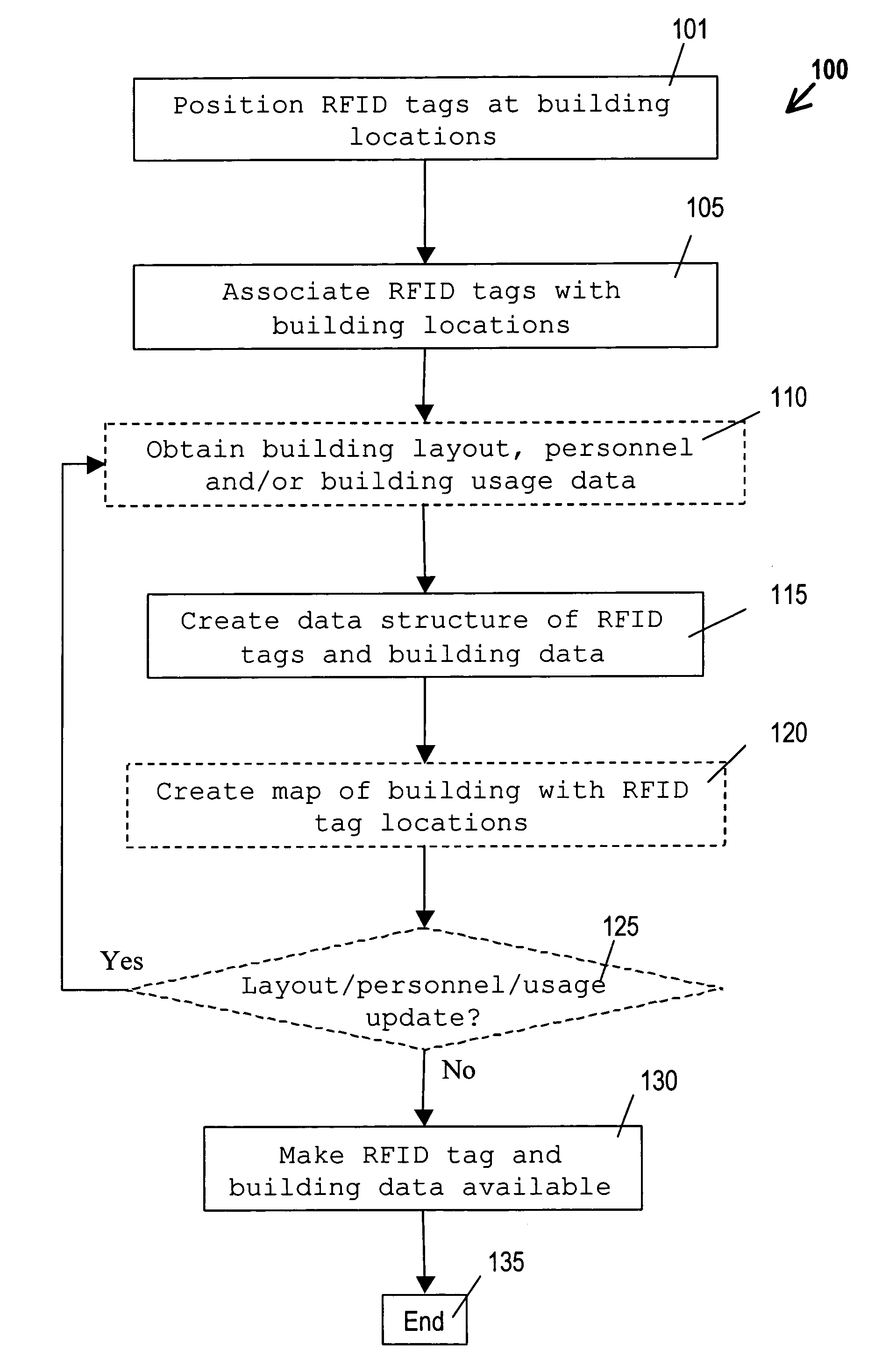
[0035]The present invention includes methods and devices for locating emergency service providers during emergency operations. One such method 100 is illustrated by the flow chart of FIG. 1. The steps of method 100 (and the other methods described herein) are not necessarily performed in the order indicated. Moreover, some aspects of the invention involve similar methods having more or fewer steps. In step 101, RFID tags are positioned at various locations throughout a building.

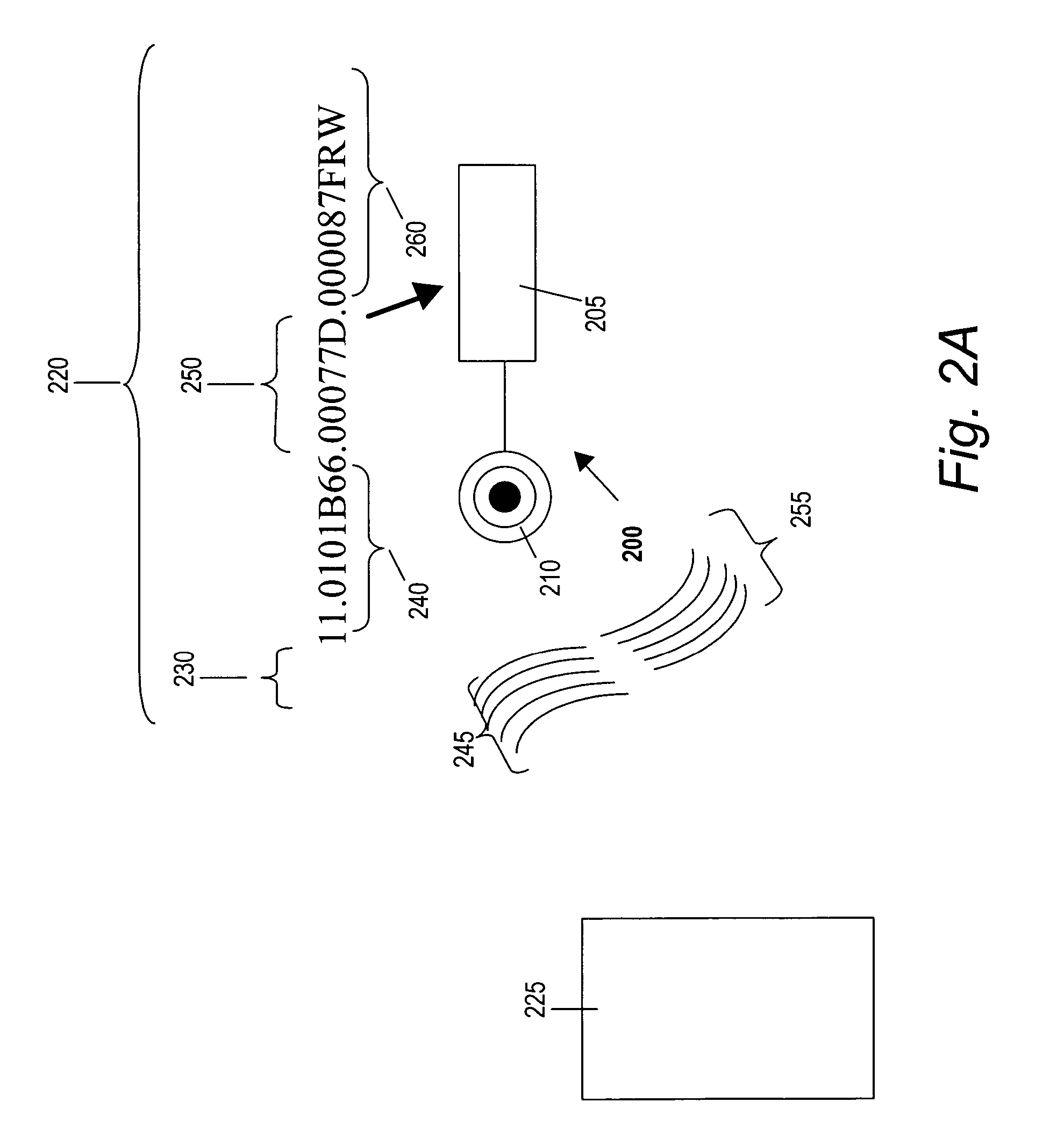
[0036]As shown in FIG. 2A, an RFID tag 200 includes microprocessor 205 and antenna 210. In this example,...


PUM


Abstract

The present invention includes methods and devices for providing. According to some implementations, radio frequency identification (“RFID”) tags are positioned at various locations throughout a building. Building locations can be determined from the RFID tags. Emergency service providers may be equipped with a portable device that includes at least one RFID reader for reading the RFID tags. Some implementations involve transmitting the RFID tag data to a control center from which the emergency services are coordinated. The emergency service workers' current and prior locations can be determined by the portable devices and / or at the control center. In preferred implementations, emergency service provider location information can be provided to control center personnel and to emergency service providers in real time.

Description

BACKGROUND OF THE INVENTION[0001]1. Field of the Invention[0002]The present invention relates to the provision of emergency services, such as fire fighting, policing, military services and special operations. More specifically, the invention relates to providing location information for emergency service workers and for others who may be coordinating emergency service operations. Although the present invention will mainly be described in terms of fire fighting operations, it applies generally to many different types of emergency service operations.[0003]2. Description of the Related Art[0004]It can be challenging to determine the location of emergency service providers during an emergency service operation. For example, when fire fighters are in a building, they are generally not familiar with the layout of the building and may become disoriented. If the building is burning, smoke may make it difficult for a fire fighter to see clearly enough to distinguish the features of the build...

Claims


Application Information

Patent Timeline
Patent Type & Authority Patents(United States)
IPC IPC(8): G08B13/14
CPCG07C9/00111G08B3/1083G08B7/06G08B13/2462G08B21/02G08B25/016G08B25/14G07C9/28
Inventor PATEL, LABHESHSHAFFER, SHMUELCHAHROURI, GEBRANSARKAR, SHANTANUMOON, BRUCEKHOURI, JOSEPH
Owner CISCO TECH INC
Why Eureka
Try Eureka