Handheld survey documentation system

a survey documentation and hand-held technology, applied in surveying and navigation, distance measurement, instruments, etc., can solve the problems of inability to further process electronically, inconvenient to use, and inability to meet the requirements of spatially coherent building layout, etc., to achieve efficient and reliable program algorithms.

Active Publication Date: 2008-03-11
HILTI AG
View PDF1 Cites 11 Cited by
  • Summary
  • Abstract
  • Description
  • Claims
  • Application Information

AI Technical Summary

Benefits of technology

[0007]It is the object of the invention to realize a survey documentation system which can be managed in an intuitively simple manner and which is based on a handheld computer and an efficient and dependable program algorithm.
[0010]By means of this algorithm, the user is intuitively urged and also compelled in practice to mark each individual measurement beforehand in the graphic representation of the building layout by means of an object. In this way, mistakes or erroneous associations which could be made especially when subsequently processed are practically eliminated.
[0011]In the marking step, an object that is already contained in the graphic representation as a basic graphic element (line, curve, polygon, circle, etc.) is advantageously marked by clicking on it so that an object can be marked quickly and intuitively by means of suitable graphic input means (cursor, input stylus, touch screen, etc.).
[0014]The optoelectronic distance measuring device is advantageously initialized in an object-specific measurement mode in the survey step in an antecedent mode-switching step, in particular: distance measurement for lines, area measurement for surfaces (multiplication of two individual measurements), and volume measurement for bodies (multiplication of three individual measurements), so that mistakes on the part of the user are avoided in practice.

Problems solved by technology

This process is cumbersome, prone to errors and costly.
It also cannot be further processed electronically and is time-consuming.
While a system of this kind is suitable for survey documentation of an individual measurement along the sight line of the laser distance measuring device, it is not suitable in principle for survey documentation of a spatially coherent building layout comprising a large number of individual measurements at different targets or aim points of different reference points.
In particular, a reliable documentation of the survey results of each individual measurement is not guaranteed.

Method used


Image

  • Handheld survey documentation system
  • Handheld survey documentation system
  • Handheld survey documentation system

Examples


Embodiment Construction

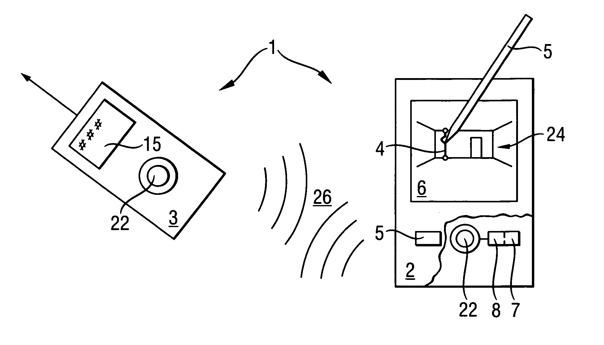
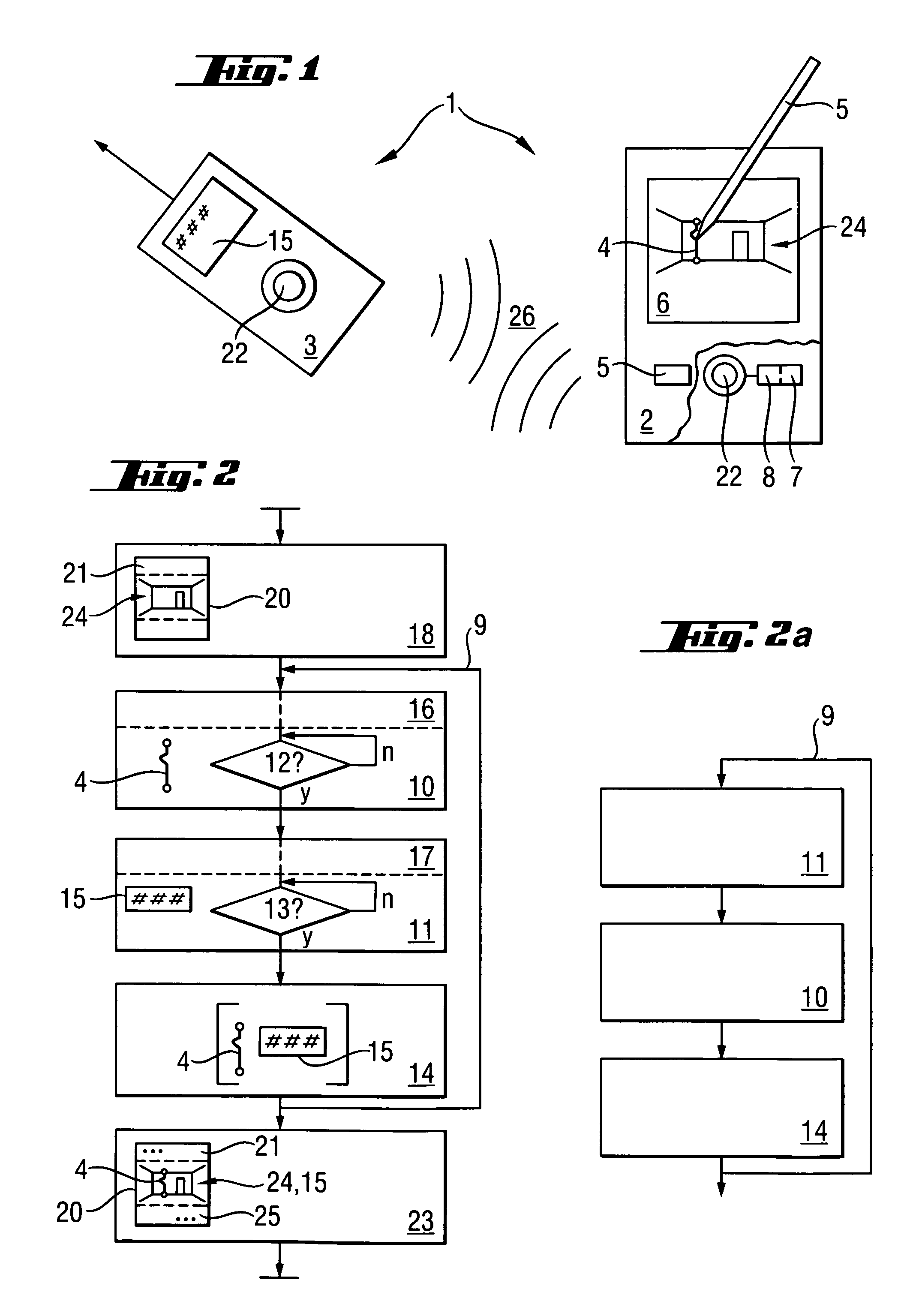
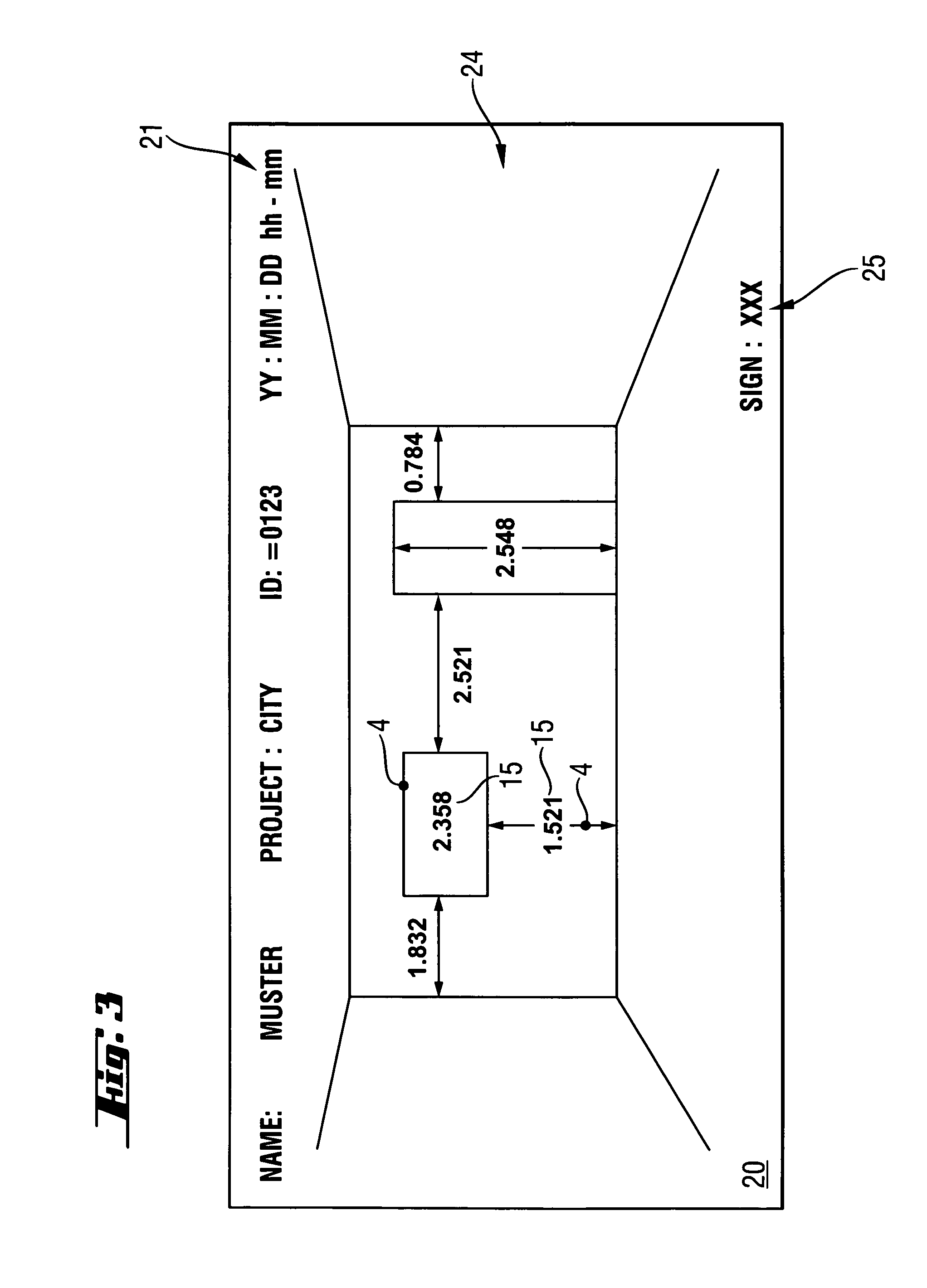
[0024]According to FIG. 1, the survey documentation system 1 comprises a handheld computer 2 which is connectable in an integrated manner to a handheld optoelectronic distance measuring device 3 in the form of a laser distance measuring device so as to communicate bidirectionally therewith by means of a wireless data interface 26 in the form of electromagnetic waves. The handheld computer 2 includes computing means 7 having an algorithm 8 executed and operated by the computing means 7, with the algorithm 8 designed for interaction with the optoelectronic distance measuring device 3. The handheld computer 2 which is constructed, in the disclosed embodiment, as a Personal Digital Assistant (PDA), has input means 5 in the form of an input stylus suitable for marking a graphic object 4, and display means 6 in the form of a graphic display suitable for displaying a graphic object 4 which displays the building layout acquired by a camera 22 integrated in the handheld computer 2 (or in the...


PUM


Abstract

A handheld computer which is connectable to an optoelectronic distance measuring device in an integrated manner so as to communicate bidirectionally therewith or connectable via a data interface, includes a computing device, an input device, and a display suitable for marking and displaying a graphic object. In a repeated sequence, an algorithm designed for interacting with the optoelectronic distance measuring device waits, in a marking step, for a marking event initiated by the user through the input device when marking an object of a graphic representation that is displayed by the display, and in a survey step which is close in time to the marking event, waits for a survey event which is triggered by a survey result measured by the user through use of the optoelectronic distance measuring device, whereupon the survey result is associated with the marked object in a subsequent association step.

Description

BACKGROUND OF THE INVENTION[0001]1. Field of the Invention[0002]The invention is directed to a handheld survey documentation system based on a handheld computer, particularly for use in the building industry, and to an associated program algorithm.[0003]2. Description of the Prior Art[0004]At the present time, when acquiring survey measurements, particularly distances, areas and volumes, for describing a building layout, sketches are usually prepared by hand to illustrate the building layout, and the survey measurements are then noted on the sketch and associated with geometric objects. Occasionally, a digital photograph of the building layout is also taken in addition for purposes of documentation. This process is cumbersome, prone to errors and costly. It also cannot be further processed electronically and is time-consuming.[0005]DE10055510 discloses a handheld laser distance measuring device which is connected to an optical camera for recording the measurement situation along the...

Claims


Application Information

Patent Timeline
Patent Type & Authority Patents(United States)
IPC IPC(8): G01C3/08G01S17/89
CPCG01C15/002G01S7/51G01S17/08G01S17/89
Inventor WAIBEL, REINHARD
Owner HILTI AG
Why Eureka
Try Eureka