Enhanced GNSS signal processing

a signal processing and enhanced technology, applied in the field of global navigation satellite systems, can solve the problems of signal refraction and multipath reception at the antenna, degrade the accuracy of gnss fixes, and signal distortion

Active Publication Date: 2009-06-02
TRIMBLE NAVIGATION LTD
View PDF9 Cites 56 Cited by
  • Summary
  • Abstract
  • Description
  • Claims
  • Application Information

AI Technical Summary

Benefits of technology

[0008]In accordance with an embodiment of the invention: (1) a hemispherical fisheye lens and accompanying imaging device are oriented such that they are fixed with respect to, and in the same plane as, the antenna element in a nearby or collocated GNSS antenna; and (2) the azimuthal orientiation with respect to a reference is known, such as from an estimated velocity vector computed by the accompanying GNSS receiver, or from a heading angle provided by an accompanying navigation system. With the orientation relationship between the GNSS antenna element and the fisheye lens and imaging device known, it is possible to relate each point in the imager's hemispherical field of view to a GNSS satellite Azimuth and Elevation angle.
[0009]Methods and apparatus in accordance with embodiments of the invention may provide for: acquiring an image representing surroundings of a GNSS antenna, determining whether an expected location of a GNSS satellite corresponds to a region of the image representing unobstructed sky, and classifying as usable the signals received from a GNSS satellite whose expected location corresponds to a region of the the image represeenting unobstructed sky.

Problems solved by technology

These obstructions can also cause signal refraction and multipath reception at the antenna due to reflections within the canopy.
Distorted signals degrade the accuracy of GNSS fixes such as fixes of position, time and velocity determined from the received signals.
Such techniques have not been found effective in the case of signals passing through or near typical obstructions found in field environments such as canopy in which the signal distortions do not follow predicted models defining multipath behavior.
Obstructions passing through the field of view of the GPS antenna may affect only a subset of the available GPS satellite signals.
However, these aforementioned methods of multipath mitigation are not satisfactory since they cannot identify specific GPS satellite signals which are affected by passing obstructions, nor can they identify specific GPS satellite signals which are not affected by passing obstructions.

Method used


Image

  • Enhanced GNSS signal processing
  • Enhanced GNSS signal processing
  • Enhanced GNSS signal processing

Examples


Embodiment Construction

[0024]The following terms are intended to have the meanings indicated, unless otherwise indicated by the context:

[0025]GALILEO comprises the Galileo satellite navigation system planned for deployment by the European Space Agency.

[0026]GLONASS comprises the Glonass satellite navigation system currently operated by the Russian Federation Ministry of Defense.

[0027]GNSS (Global Navigation Satellite System) comprises generically the GPS, GLONASS and GALILEO systems, similar satellite-based navigation systems which may from time to time become operational, and pseudolite systems.

[0028]GPS comprises the NAVSTAR Global Positioning System deployed by the United States Department of Defense, as it currently exists and as it may exist with future modernization.

[0029]A pseudolite, also called a pseudo-satellite, is a transmitter of GNSS-like signals. A pseudolite is typically terrestrial.

[0030]A satellite is a transmitter of GNSS signals, and is intended to include a pseudolite.
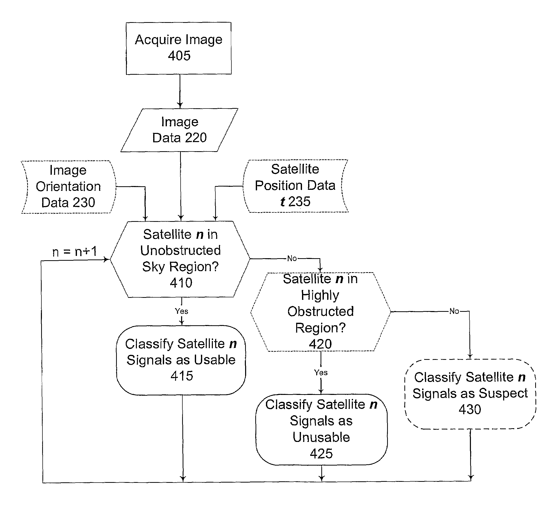
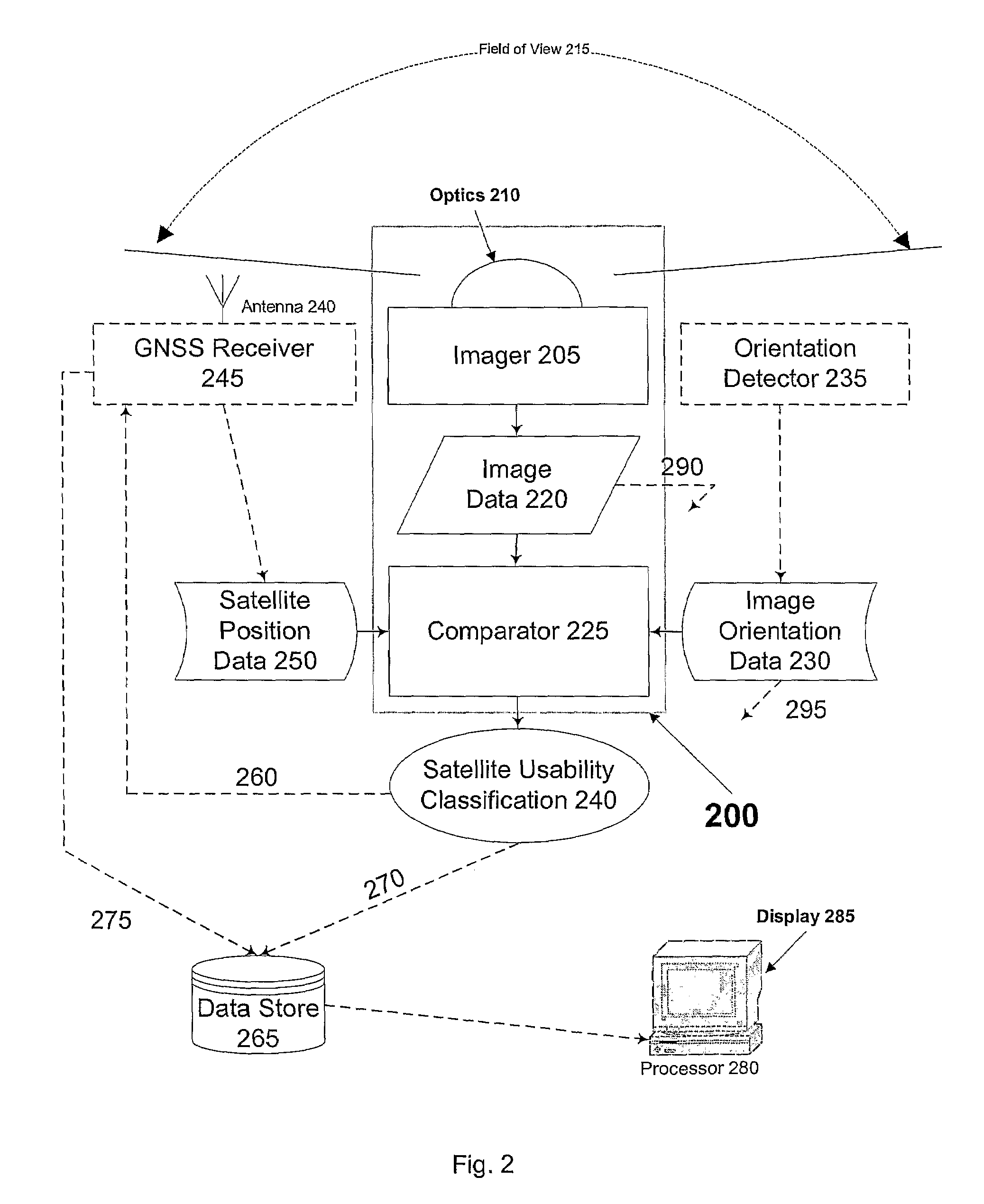
[0031]FIG. 2 sch...


PUM


Abstract

In accordance with embodiments of the invention, a skyward-looking sensor enables classification of points in its hemispherical field of view as either sky, partial sky or not sky, which in turn enables determination from data supplied by the GNSS receiver of whether each satellite in the GNSS antenna's field of view is in a region of sky, partial sky or not sky. Pseudrange and phase data from GNSS satellites determined to be in a region of sky can be considered reliable and used with confidence in a positioning solution. Pseudrange and phase data from GNSS satellites determined to be in a region of partial sky can be considered suspect and can therefore only contribute to a position solution with limited confidence and decreased accuracy. Pseudorange and phase data from GNSS satellites determined to be in a region of no sky can be considered unreliable and excluded from use in a positioning solution.

Description

TECHNICAL FIELD[0001]The present invention relates to the field of Global Navigation Satellite Systems. More particularly, the present invention relates to selection for processing of GNSS signals from satellites in view of a receiver.BACKGROUND ART[0002]Global Navigation Satellite Systems (GNSS) include the Global Positioning System (GPS), Glonass, and the proposed Galileo system.[0003]FIG. 1 illustrates a typical prior-art problem with GNSS signal reception. The antenna of a GNSS receiver such as antenna 105 is disposed for receiving signals from satellites such as satellites 3, 7, 8, 10, 12, 22. Reception of signals from satellites in line-of-sight view of antenna 105 is generally good. Signals received from satellites blocked by obstructions such as building 110 and tree canopy 115 are attenuated and distorted. These obstructions can also cause signal refraction and multipath reception at the antenna due to reflections within the canopy. Distorted signals degrade the accuracy of...

Claims


Application Information

Patent Timeline
Patent Type & Authority Patents(United States)
IPC IPC(8): G01S5/14G01S19/11
CPCG01S19/28
Inventor SEVER, MANFRED DIETER MARTINALLISON, MICHAEL TIMO
Owner TRIMBLE NAVIGATION LTD
Why Eureka
Try Eureka