
System and method for estimating the geographical location and proximity of network devices and their directly connected neighbors

a network device and geographic location technology, applied in the field of network and system management, can solve the problems of inability to accurately estimate the geographical location and proximity of network devices, high cost of maintaining data, and inability to achieve accurate data, so as to achieve the effect of increasing the capability

Active Publication Date: 2009-06-02
SAP AG
View PDF5 Cites 31 Cited by
  • Summary
  • Abstract
  • Description
  • Claims
  • Application Information

AI Technical Summary

Benefits of technology

[0010]As a result of the summarized invention, technically we have achieved a solution to the problem of determining a geographic location of resources or devices in a network. A method is provided for estimating a geographic location of each device in the network. The method may be implemented in a network management application and provide increased capability.

Problems solved by technology

It can be a challenge for users of network management applications to determine a geographic location for each resource of the network they manage.
One disadvantage of the data intensive techniques is that these techniques depend on accurate data.
It can be expensive to maintain the data and if the data is not maintained, then the techniques can be prone to error.
However, the location returned by the technique may be inaccurate due to an outdated database.
A further challenge for users of network management applications is that although some devices in the network may be automatically located using the data intensive techniques, other devices connected to the located devices may not be located due to a lack of available information or inaccurate information.

Method used


Image

  • System and method for estimating the geographical location and proximity of network devices and their directly connected neighbors
  • System and method for estimating the geographical location and proximity of network devices and their directly connected neighbors
  • System and method for estimating the geographical location and proximity of network devices and their directly connected neighbors

Examples


Embodiment Construction

[0017]Disclosed are techniques for estimating a location of a resource in a managed network. The techniques enable a user to estimate the location through the use of a number of sub-techniques that individually may produce inaccurate results. The techniques, which include methods and apparatus, use “constrained optimization” to overcome the inaccuracies of the sub-techniques.

[0018]In the constrained optimization disclosed herein, constraints are imposed by various characteristics of a particular technology. For example, Synchronous Optical Network (SONET) links are generally long haul links while Ethernet links are generally used for a short haul. Thus, a resource linked with a SONET can be presumed to be located a long distance from another resource linked with the SONET. Constrained optimization produces a “best fit” of the geographic locations while maximizing adherence to the constraints.

[0019]In one embodiment, the constrained optimization is based on “Fuzzy Logic” and is refer...


PUM


Abstract

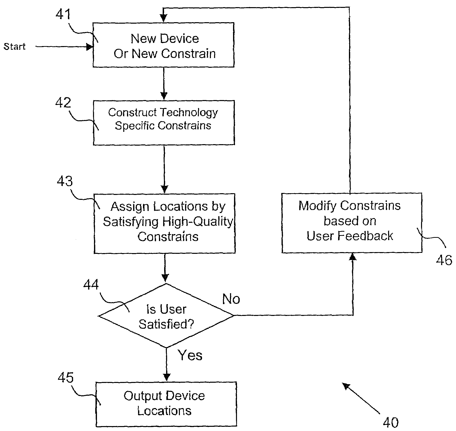
A method for estimating locations of devices in a network, the method including: identifying each of the devices; inputting an approximate location of at least one of the devices; constructing a constrain for each of the devices, the constrain comprising at least one of a type of connectivity of the device and a technology characteristic related to the device; deriving an optimization criterion on a location for each of the devices, the criterion assigning a positive weight to each constrain that is satisfied by at least one of an estimated location and the approximate location and assigning a negative weight to each constrain that is not satisfied by at least one of the estimated location and the approximate location; calculating a best fit location for each of the devices that maximizes the optimization criterion; presenting the best fit location for each of the devices to a user, the user either accepting or rejecting each best fit location, the user providing additional information for constructing each constrain associated with a rejected best fit location; and iterating at least one of the identifying, the inputting, the constructing, the deriving, the calculating, and the presenting using the additional information until the user accepts each best fit location.

Description

BACKGROUND OF THE INVENTION[0001]1. Field of the Invention[0002]The present invention relates to network and system management. More specifically, the invention relates to a computer-implemented method and system that can identify the geographic location of a device by using information for various networking technologies.[0003]2. Description of the Related Art[0004]It is important for an operator of a network to be able to locate the resources that make up the network. The operator needs to know the location of each resource in order to provide planning, upgrades, inventory control, troubleshooting, or repairs for example.[0005]It can be a challenge for users of network management applications to determine a geographic location for each resource of the network they manage. A number of data intensive techniques can be used to identify the location of a resource. One disadvantage of the data intensive techniques is that these techniques depend on accurate data. It can be expensive to...

Claims


Application Information

Patent Timeline
Patent Type & Authority Patents(United States)
IPC IPC(8): G06F15/177G05B19/418H04W4/00G06F15/16H04L12/28G06F15/173
CPCG06Q10/06312H04L12/24H04L41/00H04L41/12
Inventor AGRAWAL, DAKSHIDUGGAN, MATTHEW E.MARTIN, DANIEL J.PAPPAS, VASILEIOS
Owner SAP AG
Learn More