Al technical title is built by PatSnap Al team. It summarizes the technical point description of the patent document.
a combined map and scale technology, applied in the field of digital mapping systems, can solve the problems of ineffective scale, incorrect distance information obtained, and associated scales with conventional graphic maps, and achieve the effect of reducing the number of problems, reducing and improving the accuracy of the scal
Active Publication Date: 2009-11-17
GOOGLE LLC
View PDF50 Cites 74 Cited by
Summary
Abstract
Description
Claims
Application Information
AI Technical Summary
This helps you quickly interpret patents by identifying the three key elements:
Problems solved by technology
Method used
Benefits of technology
Problems solved by technology
Note that such a scale would be ineffective, however, if the map is zoomed or otherwise reproduced at a size different than the original map size to which the written scale was directed.
Thus, if a user attempts to measure an inch on a modified version of the map, incorrect distance information will be obtained.
However, such conventional graphic map scales are also associated with a number of problems.
For instance, some graphical scales are not always updated with panning and zoom or resize operations performed by the user.
Method used
Image
Click on the blue label to locate the original text in one second.
Reading with bidirectional positioning of images and text.
Examples
Embodiment Construction
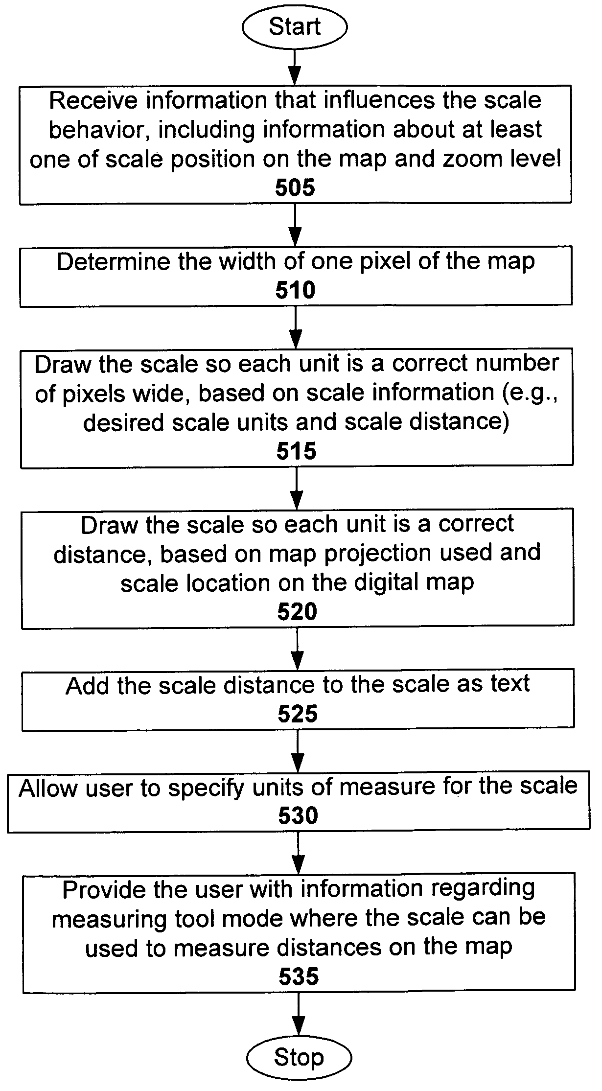
[0021]A combined map scale and measuring tool is disclosed herein that can be used in a digital mapping system. To provide added functionality to the scale without incurring undesirable processing delay, the scale is drawn on the client side. Thus, it can be quickly updated with every pan, zoom or resize operation the user performs. The user can also manipulate the scale to, for example, set its units and use it as a distance measuring tool. However, it is possible that the same functionality could be provided from the server side, but with processing delay.
[0022]Overview
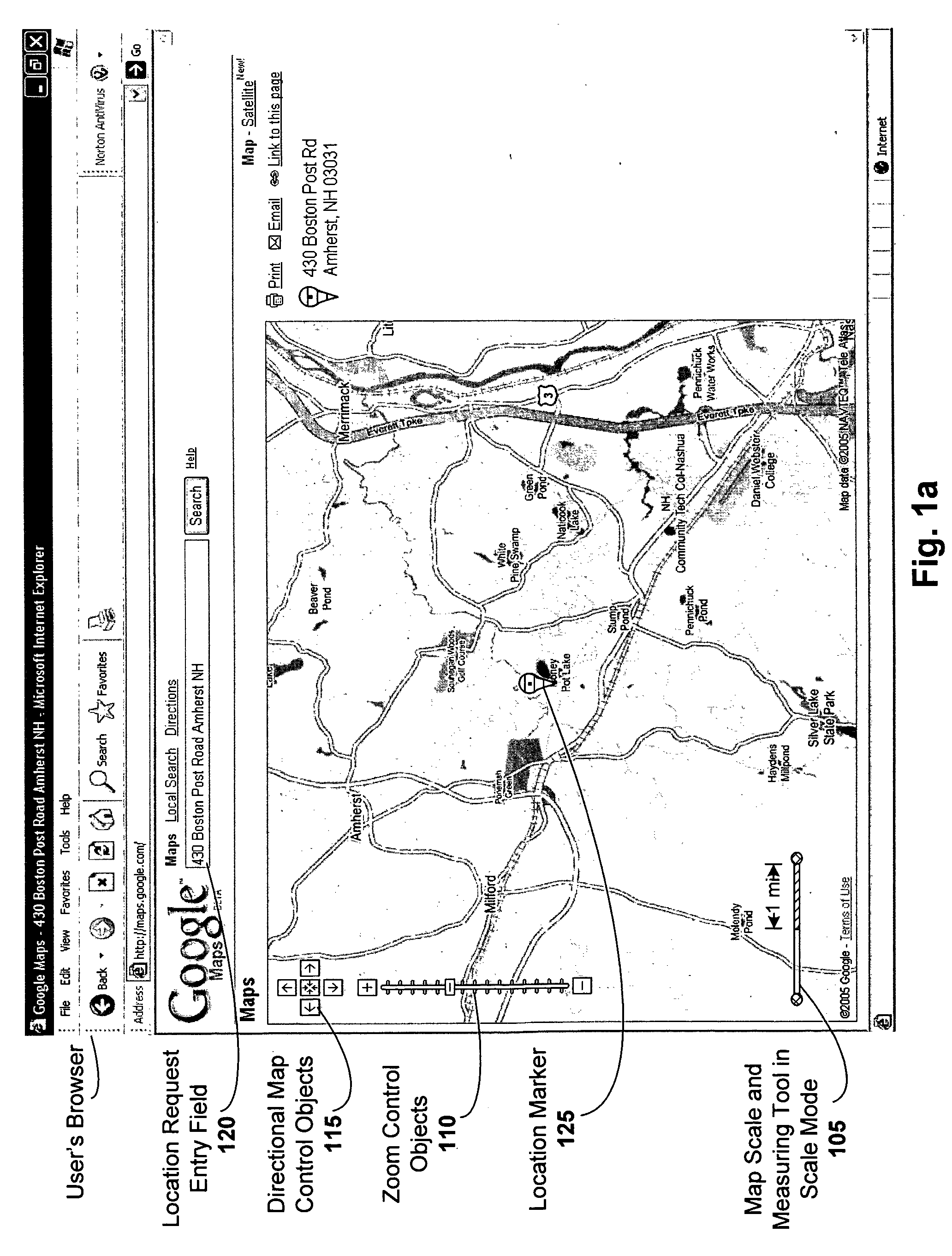
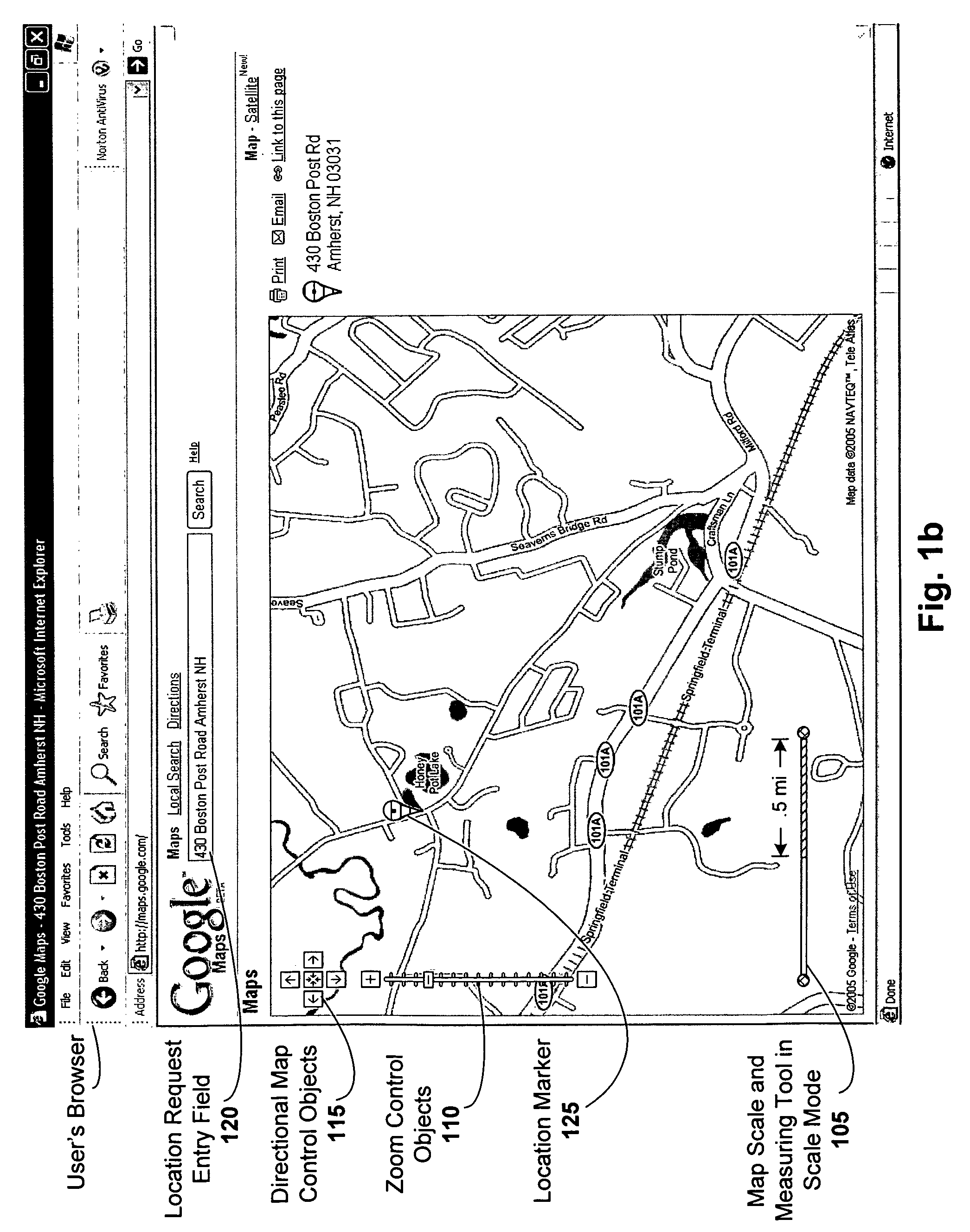
[0023]The combined map scale and measuring tool has two general modes of operation: scale mode and tool mode: In the scale mode, the scale indicates the correct scale, for instance, at the center of the map, or at the position on the map that the scale occupies. In more detail, the scale varies at different points on the map view, depending on the map projection used. Thus, a tool tip can be used to indicate where t...
PUM
Abstract
A combined map scale and measuring tool can be used in digital mapping systems. In the scale mode, the scale indicates the correct scale, for example, at the center of the map. It can be updated with every pan, zoom or resize operation the user performs, and can further update to compensate for map distortion caused by the map projection. The tool mode is entered once the user drags one or both of the scale endpoints onto the map. The distance between two endpoints of the tool can be displayed. A new point can be added each time the user drags a line between existing endpoints of the tool. Info windows can be opened that include relevant information about the endpoints (e.g., latitude / longitude, geo code), and provide option to convert the tool segments to driving directions. A drag and drop location marker is also provided.
Description
RELATED APPLICATIONS[0001]This application is a continuation-in-part of U.S. application Ser. No. 11 / 051,534, filed Feb. 5, 2005 now U.S. Pat. No. 7,158,878, titled “A Digital Mapping System”, which claims the benefit of U.S. Provisional Application Nos. 60 / 567,946, filed May 3, 2004, and 60 / 555,501, filed Mar. 23, 2004. In addition, this application is related to U.S. application Ser. No. 11 / 088,542, filed Mar. 23, 2005, titled “Generating and Serving Tiles in a Digital Mapping System”. Each of these applications is herein incorporated in its entirety by reference.FIELD OF THE INVENTION[0002]The invention relates to digital mapping systems, and more particularly, to techniques that provide more accurate and useful map scales.BACKGROUND OF THE INVENTION[0003]Computerized mapping systems have been developed to search for, identify, and discover information about geographic locations. One form of such computerized mapping systems includes travel-planning Internet websites. With an exc...
Claims
Application Information
Patent Timeline
Application Date:The date an application was filed.
Publication Date:The date a patent or application was officially published.
First Publication Date:The earliest publication date of a patent with the same application number.
Issue Date:Publication date of the patent grant document.
PCT Entry Date:The Entry date of PCT National Phase.
Estimated Expiry Date:The statutory expiry date of a patent right according to the Patent Law, and it is the longest term of protection that the patent right can achieve without the termination of the patent right due to other reasons(Term extension factor has been taken into account ).
Invalid Date:Actual expiry date is based on effective date or publication date of legal transaction data of invalid patent.