Method and system for automated planning using geographical data

a technology of geographic data and automated planning, applied in the field of engineering, can solve the problems of merely representational illustrations and may not be drawn to scal

Active Publication Date: 2010-02-16
AT&T INTPROP I L P
View PDF29 Cites 129 Cited by
  • Summary
  • Abstract
  • Description
  • Claims
  • Application Information

AI Technical Summary

Problems solved by technology

Additionally, the illustrations are merely representational and may not be drawn to scale.

Method used


Image

  • Method and system for automated planning using geographical data
  • Method and system for automated planning using geographical data
  • Method and system for automated planning using geographical data

Examples


Embodiment Construction

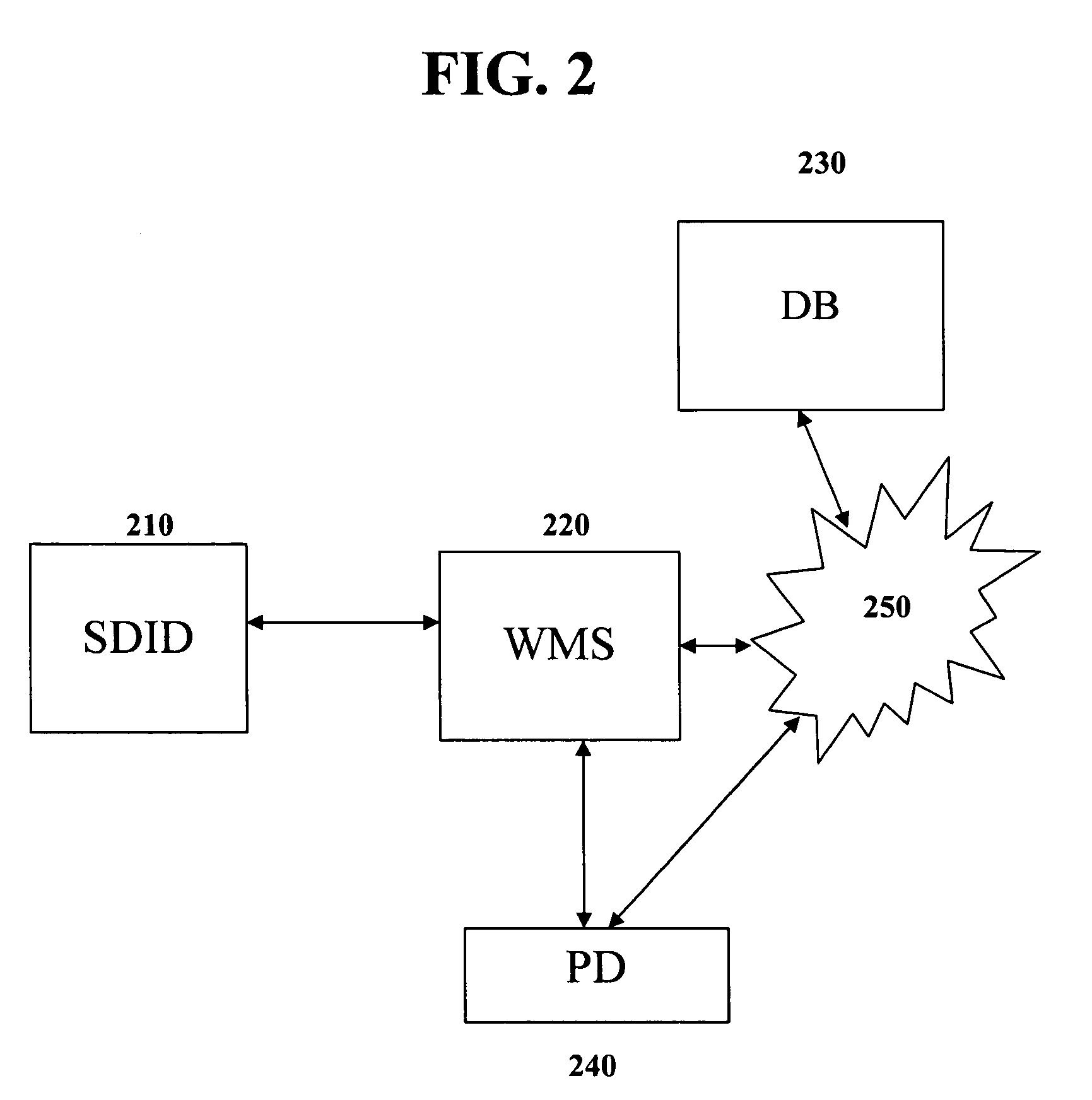
[0019]A portable smart data input device (SDID), which is connectable to a work management system (WMS), includes the capability to determine geographic position information in real time, e.g., through a GPS receiver. This allows a user, such as a field engineer surveying a potential work site, to download initial data from the WMS, such as draft work print data or other such site planning information, as well as upload additional data to the WMS. Typically, a work print is a two-dimensional plat, including geographically specific site information such as road boundaries, building structures, manholes, fire hydrants, and telephone poles.

[0020]The exemplary system of the present disclosure allows the user to visit a specific geographic location, such as a proposed work site, with the SDID. The SDID is able to download data in real time from the WMS, or to retrieve previously stored data from a memory device. The SDID enables the user to input field notes corresponding to exact geogra...


PUM


Abstract

A portable device for collecting data at a geographic location and providing accurate, comprehensive, efficient and timely work prints. The portable device for collecting data at a geographic location, the device including a memory that stores preliminary site information associated with the geographic location; a receiver that receives geographic position data of at least one point at the geographic location; an interface that enables a user to input data corresponding to the received geographic position data; and a processor that supplements the preliminary site information with the received geographic position data and the corresponding input data.

Description

BACKGROUND OF THE DISCLOSURE[0001]1. Field of the Disclosure[0002]The present disclosure relates to the field of engineering. More particularly, the present disclosure relates to gathering, managing and outputting site specific planning or other such location specific information correlating to geographical data.[0003]2. Background of the Disclosure[0004]Currently, project management entities survey worksites and other geographically specific locations in order to develop work prints by sending field engineers to these work sites. A field engineer typically may carry, for example, a preliminary work print, a notebook, a cellular telephone, a camera, and the like. Once at the work site, the engineer may use a measuring wheel to measure and record geographic information. The engineer takes separate notes on such observations as field hazards, placement of items such as culverts, and fence lines, and required work such as boring, tree trimming, bonding and grounding, to name a few.[000...

Claims


Application Information

Patent Timeline
Patent Type & Authority Patents(United States)
IPC IPC(8): H04M1/00
CPCG01C15/00G06F17/30241G01S19/14G06F16/29
Inventor SKELTON, CHRISTOPHER
Owner AT&T INTPROP I L P
Why Eureka
Try Eureka