Survivability system

a survivability and planning system technology, applied in the direction of process and machine control, instruments, navigation instruments, etc., can solve the problems of limiting the options of the aircraft operator, evading maneuvers, and unplanned problems

Inactive Publication Date: 2010-12-07
LOCKHEED MARTIN CORP
View PDF24 Cites 43 Cited by
  • Summary
  • Abstract
  • Description
  • Claims
  • Application Information

AI Technical Summary

Problems solved by technology

However, conventional route planning must also take into account the problem of unplanned threats, unknown at the time, which might “pop up” during the mission.
This approach limits the options of the aircraft operator, forces evasive maneuvers that are not optimized for an unknown threat, and is often slow.
These approaches do not consider the elapsed time required between initial detection of the aircraft by a threat and the threat's actually ability engage and fire upon the aircraft.

Method used


Image

  • Survivability system
  • Survivability system
  • Survivability system

Examples


Embodiment Construction

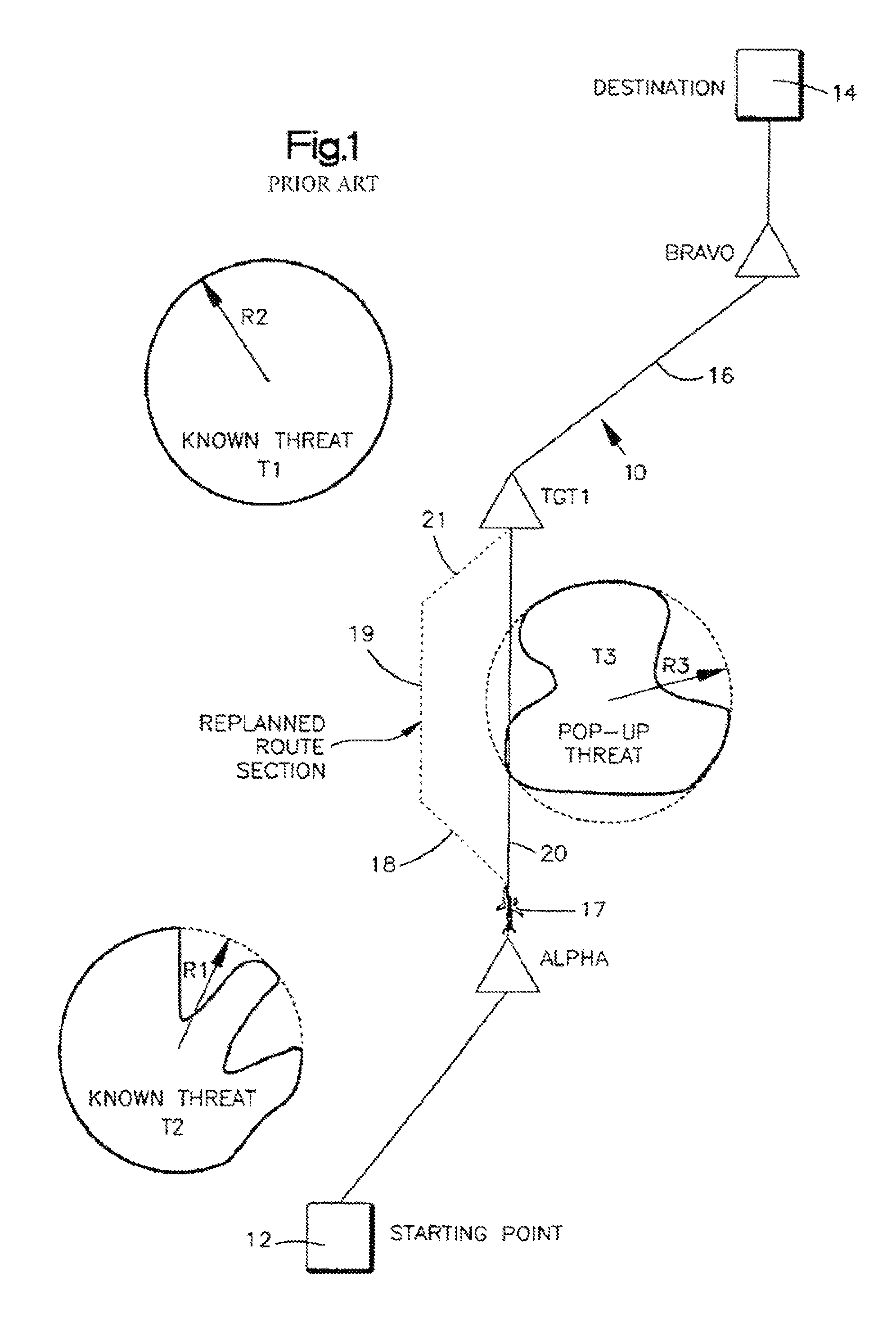
[0018]To better appreciate and understand the scope of the invention, an example of a conventional approach to the problem of avoiding previously unknown threats that appear without warning is described below. FIG. 1 illustrates known threats T1, an antiaircraft battery, and T2, a radar site, each having a maximum intervisibility range R1, R2, respectively. Intervisibility is the capability of both the threat and the aircraft to detect, or be visible to, each other. Ideally, the aircraft detects the threat before intersecting a threat's intervisibility.

[0019]However, the nature of the terrain may affect intervisibility. For example, R1 may not be circular because a mountain range may block the view of T1, an antiaircraft battery. A planned route 10 may include a starting point 12, an ending point or destination 14, and a number of intermediate waypoints such as Alpha, TGT1, and Bravo. Connecting each waypoint of the planned route is a leg, such as leg 16 between waypoints TGT1 and B...


PUM


Abstract

A system determines a course of action for a vehicle. The system includes an altitude module, a threat detection module, a route module, and a threat avoidance module. The altitude module contains a list of types of threats. The list includes a predetermined threshold time for maximum safe visibility by the vehicle for each type. The threat detection module detects threats. The route module stores a planned route for the vehicle. The threat avoidance module determines types of threats detected by the threat detection module. The threat avoidance module utilizes the predetermined threshold times from the altitude module for each threat detected by the threat detection module to determine whether the planned route may safely enter visibility range of each threat detected by the threat detection module.

Description

FIELD OF INVENTION[0001]The present invention relates to a planning system for optimizing mission survivability. More particularly, the present invention relates to a system for planning a course of action in response to sensed situational conditions by utilizing data from specific timeline modeling.BACKGROUND OF THE INVENTION[0002]Conventional survivability systems are computer-based systems for detecting and navigating aircraft around detected threats. In planning the route of an aircraft's mission, known threats such as hostile ground fire, military positions, etc., are taken into account. The planned route, which may be stored in the aircraft's computer system, includes a starting point, a number of intermediate waypoints, and an ending point. The distance between each waypoint may be measured in nautical miles and referred to as a leg. Thus, a conventional planned route consists of a number of connected legs that angle around known threats to provide a safe route between the ai...

Claims


Application Information

Patent Timeline
Patent Type & Authority Patents(United States)
IPC IPC(8): G06F19/00
CPCG05D1/0202G01C21/20
Inventor HERMAN, CARL R.
Owner LOCKHEED MARTIN CORP
Why Eureka
Try Eureka