Predicting geographic population density

a geographic population and density technology, applied in the field of location-based services, can solve the problems of poor accuracy of geographic population density determination, noisy mobile phone data, and sparse mobile phone data

Inactive Publication Date: 2013-07-02
GOOGLE LLC
View PDF8 Cites 23 Cited by
  • Summary
  • Abstract
  • Description
  • Claims
  • Application Information

AI Technical Summary

Problems solved by technology

Accurately determining geographic population density is difficult.
However, mobile phone data are sparse.
The mobile phone data are also noisy.
The data are also noisy as a result of the localization errors of individual mobile phones.

Method used


Image

  • Predicting geographic population density
  • Predicting geographic population density
  • Predicting geographic population density

Examples


Embodiment Construction

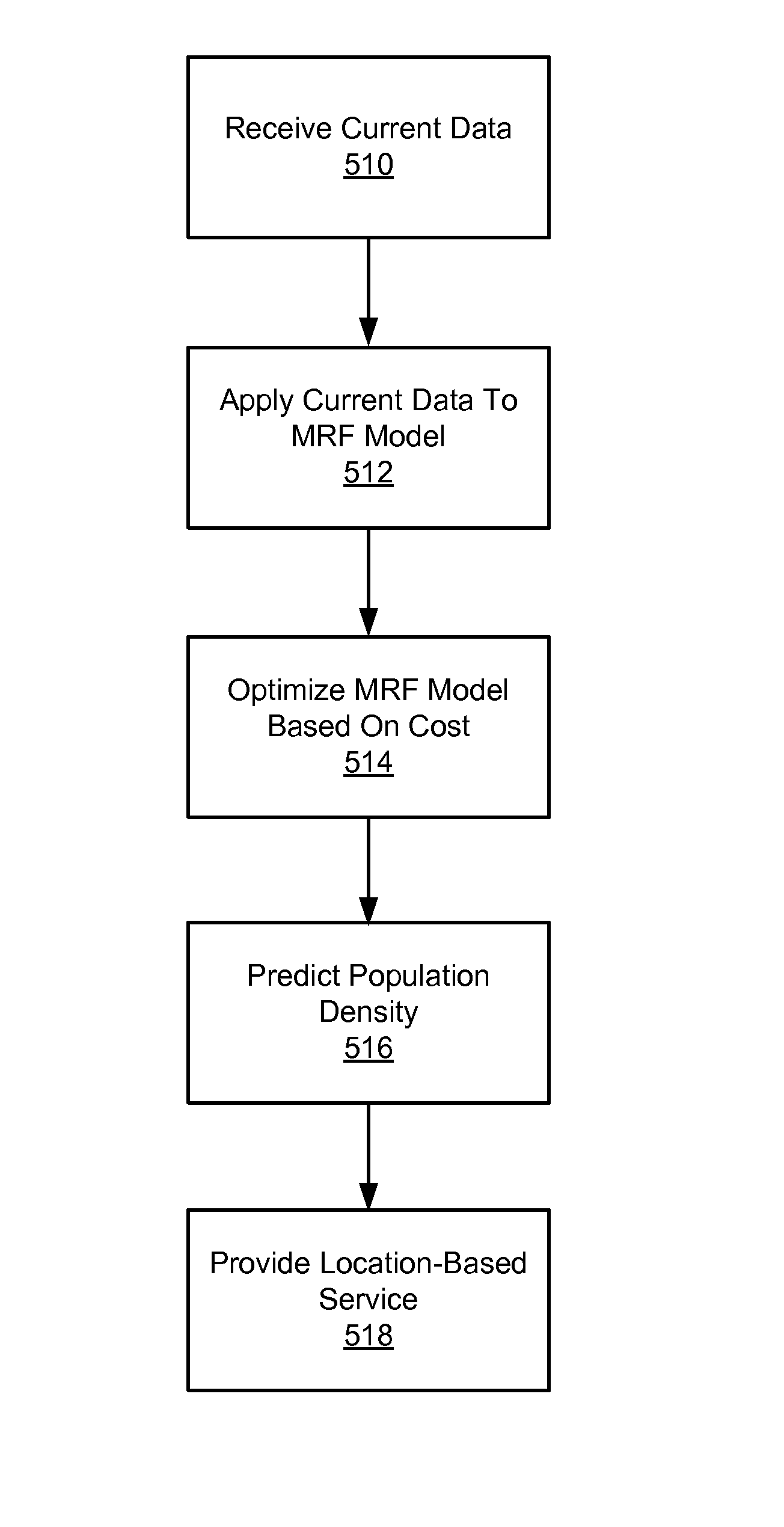
[0015]The Figures (FIGS.) and the following description describe certain embodiments by way of illustration only. One skilled in the art will readily recognize from the following description that alternative embodiments of the structures and methods illustrated herein may be employed without departing from the principles described herein. Reference will now be made in detail to several embodiments, examples of which are illustrated in the accompanying figures. It is noted that wherever practicable similar or like reference numbers may be used in the figures and may indicate similar or like functionality.

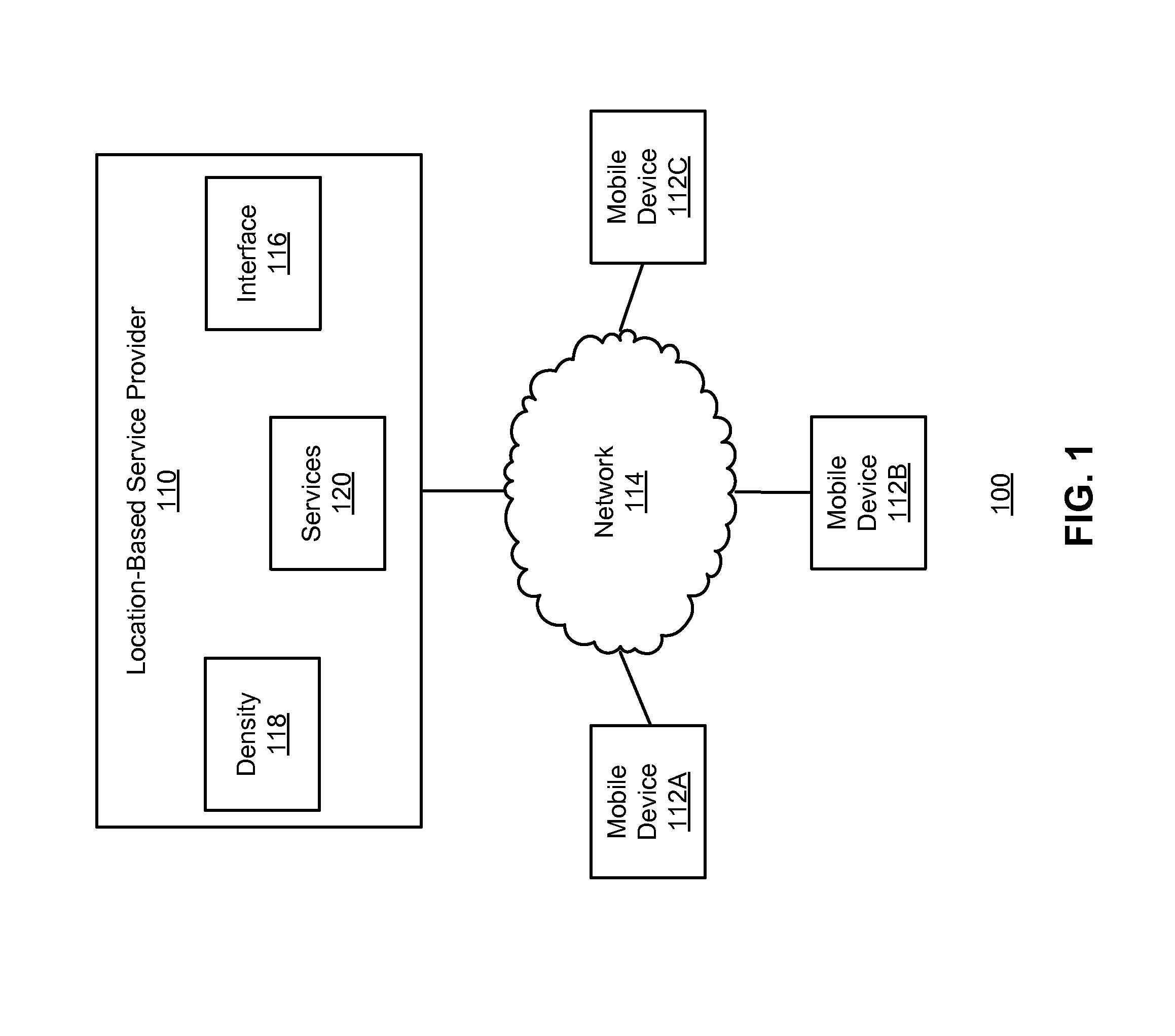
[0016]FIG. 1 is a high-level block diagram that illustrates a computing environment 100 for estimating geographic population density according to one embodiment. As shown, the computing environment 100 includes a location-based service provider (the “service provider”) 110 and multiple mobile devices 112A-C connected through a network 114. Only one service provider 110 and three mobi...


PUM


Abstract

The population density for a geographic area is predicted using a Markov Random Field (MRF) model. A MRF model is defined for estimating a number of mobile devices being used within a geographic area. The MRF model includes a set of rules describing how to use current data describing mobile devices currently observed in the area, and historical data describing mobile devices historically observed in the area to produce the estimate. Values of weight parameters in the MRF model are learned using the historical data. The current and historical data are applied to the MRF model having the learned weight parameters, and cost minimization is used to estimate of the number of mobile devices currently being used within the area. This estimate is used to predict the population density for the area. The predicted population density can then be used to provide location-based services.

Description

BACKGROUND[0001]1. Field of Disclosure[0002]This disclosure relates in general to the field of location-based services and in particular to predicting geographic population density to provide and improve such services.[0003]2. Description of the Related Art[0004]Location-based services are growing in popularity. Many modern mobile devices, such as mobile telephones, are equipped with functionality allowing determination of the devices' geographic positions. This positioning information is used, in turn, to provide location-based services such as maps of the geographic areas proximate to the devices.[0005]Geographic population density, defined as the number of people within a geographic area, can be used to enhance location-based services. For example, geographic population density can be used to estimate traffic congestion on roads within an urban area. Likewise, population density can be used to estimate the time required to find a parking space in an urban area.[0006]Accurately de...

Claims


Application Information

Patent Timeline
Patent Type & Authority Patents(United States)
IPC IPC(8): H04W24/00
CPCH04W4/021H04W16/22
Inventor LOOKINGBILL, ANDREWTHRUN, SEBASTIAN
Owner GOOGLE LLC
Why Eureka
Try Eureka