Dynamic geotagging of photographs

a geotagging and dynamic technology, applied in the field of wireless telecommunications networks, can solve the problems of not being able to quickly drain the cell phone battery of the gps receiver, not being able to quickly determine the location without assistance data, and not being able to incorporate a more powerful gps receiver

Active Publication Date: 2013-10-01
CINGULAR WIRELESS II LLC
View PDF6 Cites 6 Cited by
  • Summary
  • Abstract
  • Description
  • Claims
  • Application Information

AI Technical Summary

Benefits of technology

[0012]The present invention relates to a wireless mobile telecommunications network method and system for geotagging an image (e.g., photo) or other multimedia message transmitted from wireless user equipment (UE) and received by the network. In an exemplary embodiment of the invention, in response to receiving the image, the network uses a conventional Location-Based Services (LBS) query to determine the geographic location of the UE. The network then tags the image with the determined geographic location. A Gateway Mobile Location Center (GMLC) or similar conventional means for determining UE location can respond to the LBS query by determining the geographic location of the UE in a conventional manner, such as by using a triangulation method.
[0013]In the exemplary embodiment of the invention, in which the network is generally of the GSM / UMTS type, a novel network element that can be referred to herein for convenience as a “geotagger” communicates with the network Multimedia Messaging Service Center (MMSC) or similar means for receiving images or other multimedia messages. When the network receives the image from the UE, the MMSC has the geotagger determine the UE geographic location and tag the image. The geotagger can act as an LBS client and query the GMLC for the UE location. Alternatively, in other embodiments of the invention, the MMSC or similar network element can itself be programmed or configured to determine the UE location and tag the image.

Problems solved by technology

Cell phones generally do not include built-in full-function GPS receivers because the phone would be undesirably large, and use of the GPS receiver would rapidly drain the cell phone battery.
As minimizing size and weight and maximizing battery charge conservation remain important goals for producers of cell phones, incorporating a more powerful GPS receiver capable of rapidly determining location without assistance data is not considered a commercially viable option.
Some cell phones whose designs emphasize portability and battery conservation simply do not include even a limited processing power GPS receiver.

Method used


Image

  • Dynamic geotagging of photographs
  • Dynamic geotagging of photographs
  • Dynamic geotagging of photographs

Examples


Embodiment Construction

[0017]In the following description, like reference numerals indicate like components to enhance the understanding of the invention through the description of the drawings. Also, although specific features, configurations, arrangements and steps are discussed below, it should be understood that such specificity is for illustrative purposes only. A person skilled in the relevant art will recognize that other features, configurations, arrangements and steps are useful without departing from the spirit and scope of the invention.

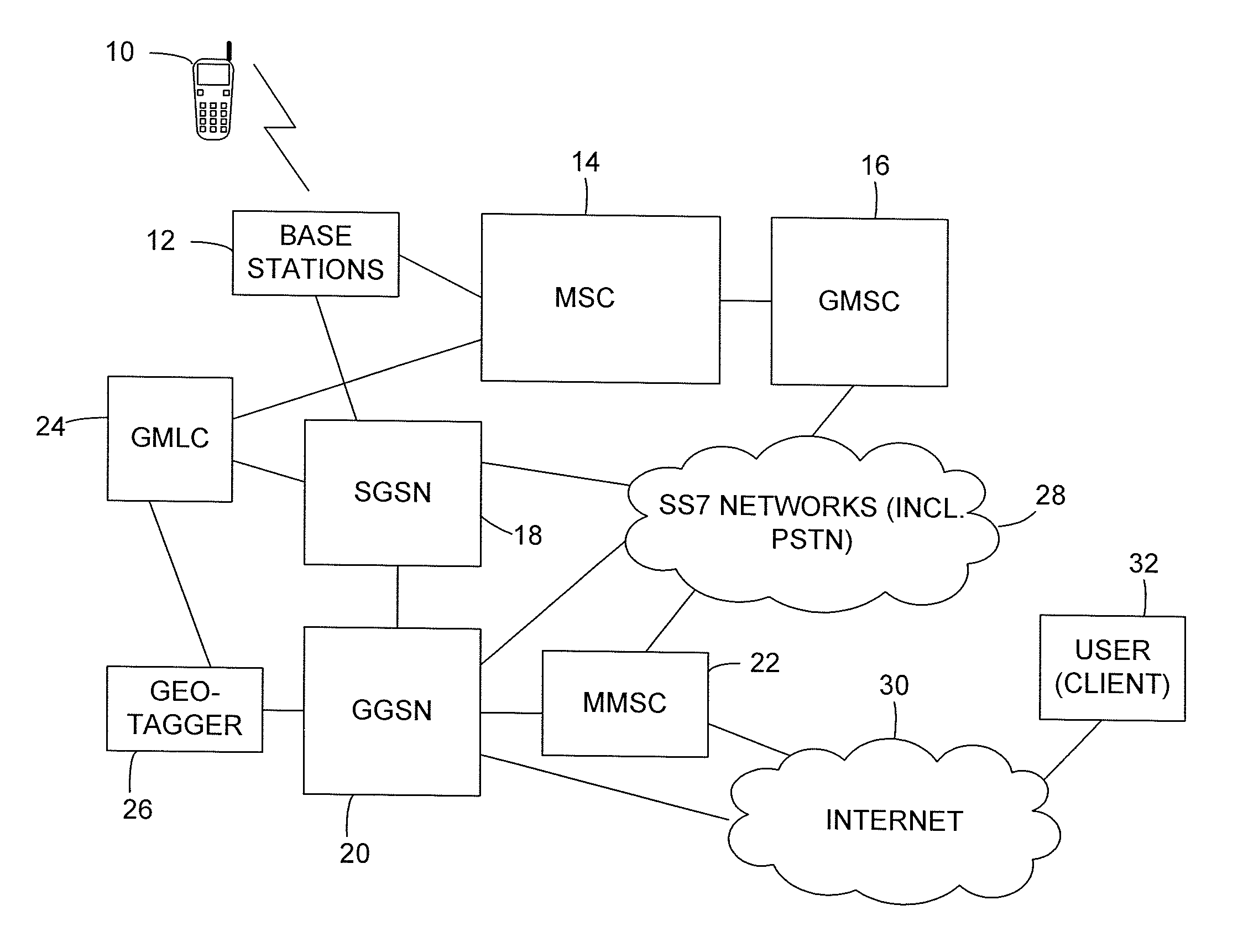
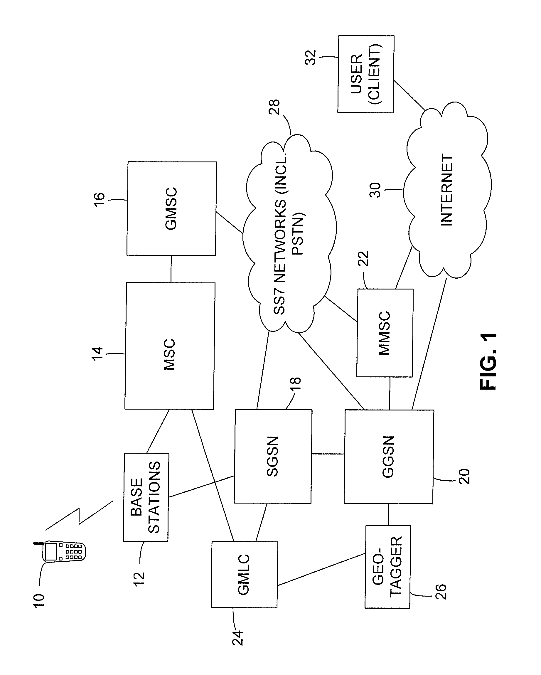
[0018]As illustrated in FIG. 1, in an exemplary embodiment of the invention a mobile telephone (also referred to as a cell phone or mobile station) or other user equipment (UE) 10 communicates with a wireless telecommunications network (also referred to as a cellular telecommunications network) having an architecture generally in conformance with the GPRS and UMTS standards. As known in the art, GPRS is a standard that has been adopted by many network service pr...


PUM


Abstract

A wireless mobile telecommunications network tags an image or other multimedia message that it receives from wireless user equipment (UE) with geographical information indicating the location of the UE. The network can determine the UE location using a conventional method such as those used in Location-Based Services.

Description

BACKGROUND OF THE INVENTION[0001]1. Field of the Invention[0002]The present invention relates generally to wireless telecommunications networks and, more specifically, to geotagging digital photographs transmitted via a wireless mobile telecommunications network.[0003]2. Description of the Related Art[0004]Geotagging, also referred to as geocoding, is the process of adding geographical identification metadata to digital data files or data sources. The data file can represent any medium, with an image (e.g., photograph) being the most common. This data generally includes a geographic location in the form of latitude and longitude coordinates, but can also include a place name, altitude and other characteristics of a specific location. In theory, every part of a digital photograph can be tied to a geographic location, but in most instances only the position of the camera is associated with the entire digital image.[0005]The most common method for geotagging a digital photo involves us...

Claims


Application Information

Patent Timeline
Patent Type & Authority Patents(United States)
IPC IPC(8): H04M11/04H04W4/021H04W4/02
CPCH04W4/02H04W4/14H04W4/185H04W4/021
Inventor MIKAN, JEFFREYCENCIARELLI, FULVIOMCNAMARA, JUSTIN
Owner CINGULAR WIRELESS II LLC
Why Eureka
Try Eureka