Server system for receiving, processing and reporting sensor data

a sensor data and server technology, applied in the field of server systems for receiving, processing and reporting sensor data, can solve problems such as affecting the accuracy of gis models

Inactive Publication Date: 2014-12-09
THE UNITED STATES OF AMERICA AS REPRESENTED BY THE SECRETARY OF THE NAVY
View PDF10 Cites 8 Cited by
  • Summary
  • Abstract
  • Description
  • Claims
  • Application Information

AI Technical Summary

Problems solved by technology

The rate at which data is uploaded to the GIS is determined entirely by the operators of the remote devices, potentially impacting the accuracy of the GIS models.

Method used


Image

  • Server system for receiving, processing and reporting sensor data
  • Server system for receiving, processing and reporting sensor data
  • Server system for receiving, processing and reporting sensor data

Examples


Embodiment Construction

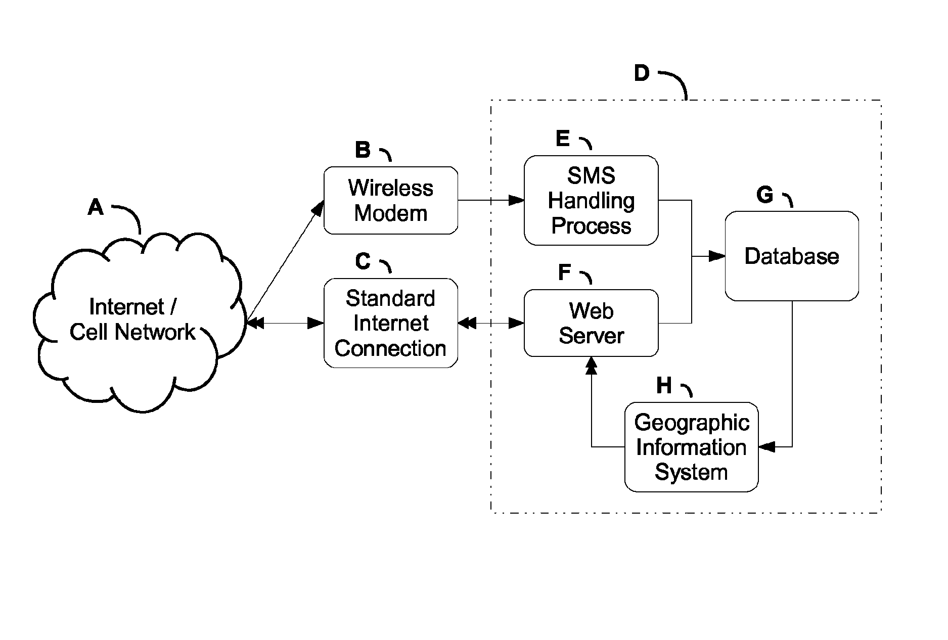
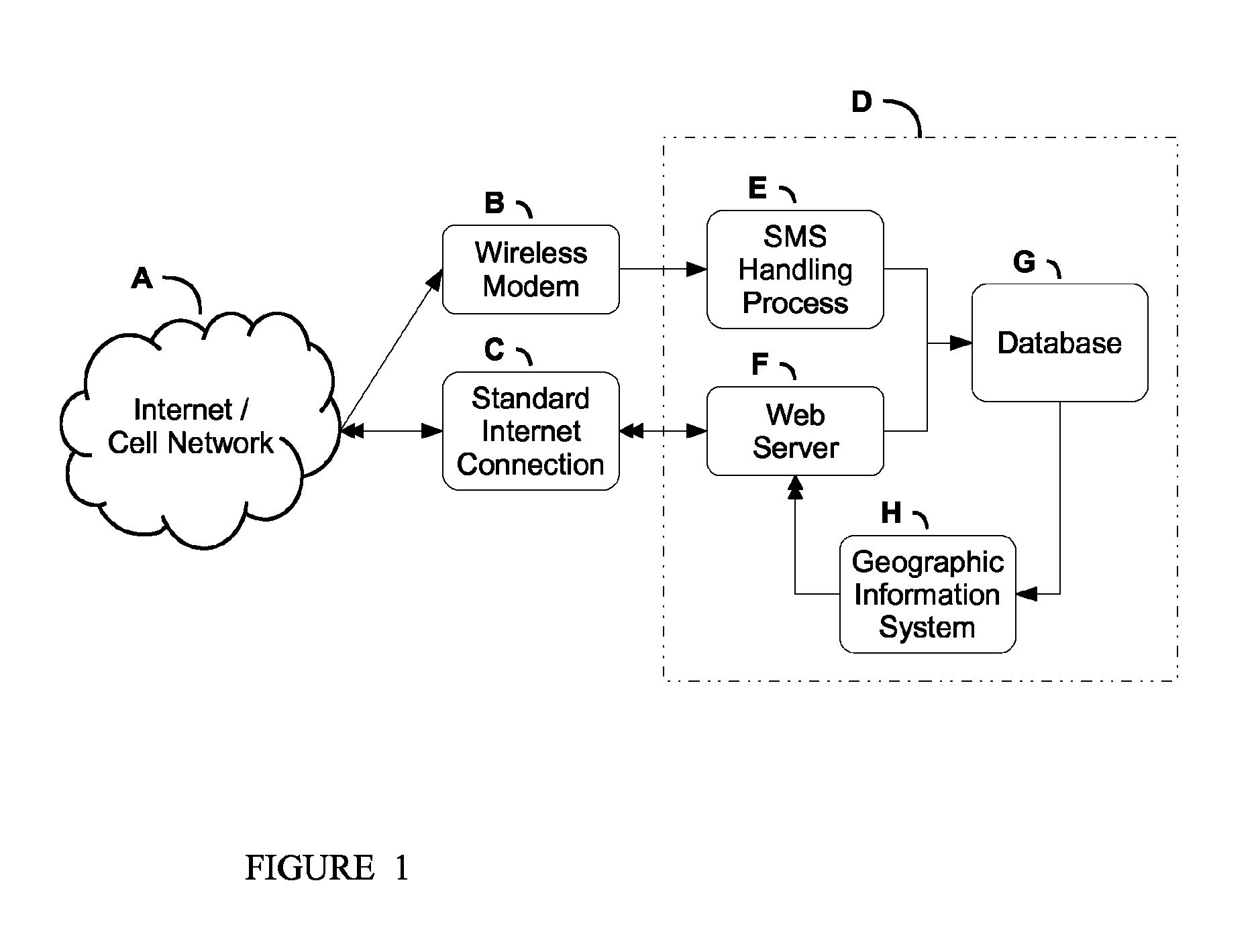
[0009]In one embodiment, a server system if provided for receiving, processing, and reporting geographic sensor data from sources that communicate through TCP / IP or Short Message Service (SMS) cellular network protocols. The geographic sensor data is representative of geospatial information and associated measurement data.

[0010]The server system comprises a database, a Geographic Information System (GIS) application, and programs to receive and process data through connections to a cellular or computer network. One purpose of the server system is to receive data transmitted over the internet or cellular network by remote sensors, process this information, and display the combined data through a GIS to users via the internet.

[0011]The sensor data can be received through a standard web interface using an internet connection or in Short Message Service (SMS) text format using a wireless modem.

[0012]SMS is a text messaging service component of phone, web or mobile communication systems,...


PUM


Abstract

In one embodiment, a server system is provided for receiving, processing and reporting sensor data from remote sources. The server system comprises a database; a Geographic Information System (GIS) application; and programs for receiving geographic sensor data from the remote sources representative of geospatial-type information through connections to a computer network and to a cellular network transmitted by the remote sources through computer network communication protocols or short message service (SMS) cellular network communication protocols; processing the received geographic sensor data for storage in the database; and displaying the processed geographic sensor data through the GIS application to users via the cellular network or the computer network.

Description

FEDERALLY-SPONSORED RESEARCH AND DEVELOPMENT[0001]This invention (Navy Case NC 101,409) is assigned to the United States Government and is available for licensing for commercial purposes. Licensing and technical inquiries may be directed to the Office of Research and Technical Applications, Space and Naval Warfare Systems Center, Pacific, Code 72120, San Diego, Calif., 92152; voice (619) 553-2778; email T2@spawar.navy.mil.BACKGROUND OF THE INVENTION[0002]The practice of using Geographic Information System (GIS) computer applications for storing and analyzing geospatial information and associated measurement data has been in place for decades. The purpose of a GIS is to collect and store geographically referenced data to allow subsequent modeling and distribution. The data is transferred to the GIS from remote devices capable of reporting GPS coordinates along with other sensor measurements. Traditional methods for transmitting geospatial data to a GIS require user interaction for bo...

Claims


Application Information

Patent Timeline
Patent Type & Authority Patents(United States)
IPC IPC(8): H04W4/00H04W24/00H04W4/90
CPCH04W4/00H04W4/22H04W4/90
Inventor HIGUCHI, EVAN Y.KAMIN, NACKIEB M.TOM, ADRIANNE
Owner THE UNITED STATES OF AMERICA AS REPRESENTED BY THE SECRETARY OF THE NAVY
Why Eureka
Try Eureka