Remote high-precision independent combined navigation locating method

A technology of integrated navigation and positioning method, which is applied in the direction of integrated navigator, navigation, and navigation through speed/acceleration measurement, which can solve the problems of filter divergence, navigation accuracy divergence, and inability to correct three-dimensional position information, and achieve the effect of improving accuracy

Inactive Publication Date: 2008-09-24
BEIHANG UNIV
View PDF0 Cites 103 Cited by
  • Summary
  • Abstract
  • Description
  • Claims
  • Application Information

AI Technical Summary

Problems solved by technology

Although inertial navigation has the advantages of strong autonomy, good concealment, maneuvering, continuous, real-time and not limited by weather conditions, the inertial navigation system has inherent disadvantages: navigation accuracy diverges with time, that is, poor long-term stability
Both EKF and UKF are filtering methods based on the Gaussian distribution of system noise and measurement noise. In practice, the noise distribution of celestial navigation systems cannot be regarded as a simple Gaussian distribution, and the precise statistical characteristics of the noise cannot be known. Therefore, EKF and UKF The filtering performance will be reduced, and even the filtering will diverge
Although PF solves the problem of non-Gaussian distribution of noise, it has a large amount of calculation and cannot meet the real-time requirements of the system, and PF also

Method used


Image

  • Remote high-precision independent combined navigation locating method
  • Remote high-precision independent combined navigation locating method
  • Remote high-precision independent combined navigation locating method

Examples


Embodiment Construction

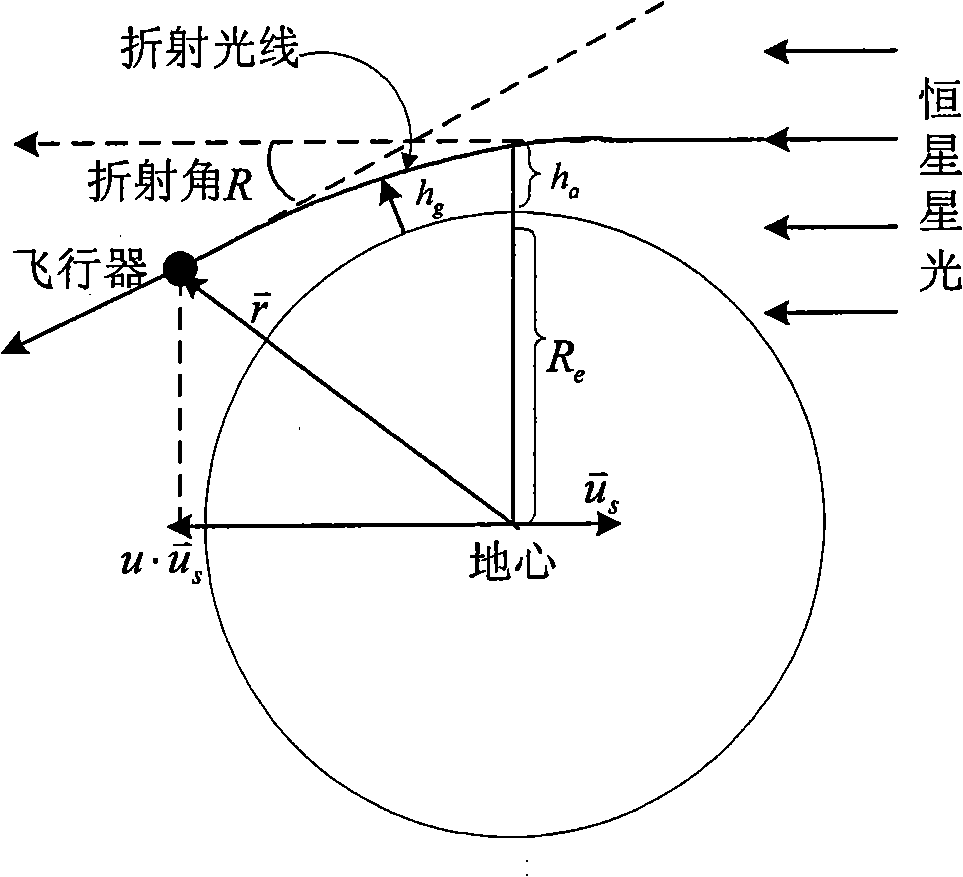
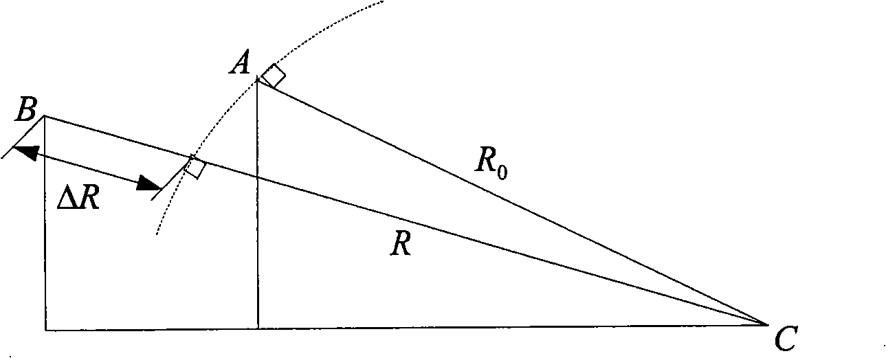
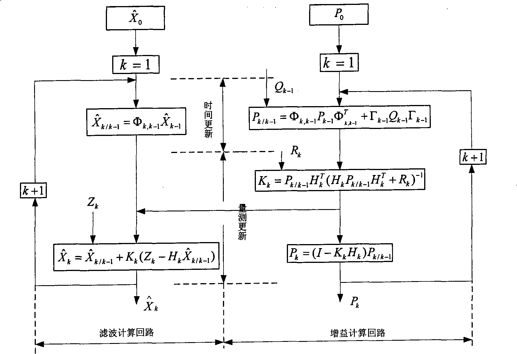
[0054] Such as figure 1 , 2 , 3, shown in 4, concrete method of the present invention is as follows:

[0055] (1) The establishment of the state model of the SINS / CNS / SAR integrated navigation system, such as formula 1.

[0056] System state equation:

[0057] X · ( t ) = F ( t ) X ( t ) + G ( t ) W ( t ) - - - ( 1 )

[0058] Among them, X(t) is the system state vector, W(t) is the system noise vector, F(t) is the system transfer matrix,

[0059] X ( t ) = ...


PUM


Abstract

The invention relates to a remote high precision autonomous integrated navigation and positioning method, which is characterized in that a Strapdown Inertial Navigation System (SINS) is used as a main navigation system during the whole flight course of the aircraft, assisted by 3D high precision position and attitude angle information provided by celestial navigation system (CNS) based on the least square differential correction in boost phase (or middle segment). In reentry phase (terminal), using the characteristics of synthetic aperture radar (SAR), such as strong penetration capability, high resolving precision and all-weather, the SINS can be corrected through accurate location information and course information provided by SAR scene matching after motion compensation when the aircraft reentry into atmospheres, so the impact point (hit) accuracy of the aircraft can be increased and the invention has remarkable effects of eliminating or decreasing non-guidance error. The invention has advantages of autonomy and high precision, which can be used for improving remote ballistic missile, remote cruise missile, navigation and positioning accuracy of remote aircraft, such as long-endurance unmanned aerial vehicle, etc.

Description

technical field [0001] The invention relates to a long-range high-precision autonomous combined navigation and positioning method, which can be used to improve the navigation and positioning accuracy of long-range ballistic missiles, long-range cruise missiles, long-endurance unmanned aerial vehicles and long-range aircraft. Background technique [0002] The technique or method of guiding a vehicle from an origin to a destination is called navigation. The navigation system measures and calculates the instantaneous motion state and position of the vehicle, and provides it to the driver or the autopilot to realize the correct manipulation or control of the vehicle. With the development of science and technology, more and more navigation information sources are available, and there are more and more types of navigation systems. Such as compass navigation using the action of the geomagnetic field; inertial navigation using gyroscopes and accelerometers to measure the accelerati...

Claims


Application Information

Patent Timeline
IPC IPC(8): G01C21/00G01C21/16G01C21/24G01C21/02G01S13/90
Inventor 王新龙马闪申亮亮谢佳
Owner BEIHANG UNIV
Why Eureka
Try Eureka