Method for interactively editing GIS topological data set

A topology data, interactive technology, applied in electrical digital data processing, special data processing applications, instruments, etc., can solve the problems of complicated operation process, limited application of topology data model, inconvenient to find and correct topology errors, etc., to improve safety. performance, productivity, and visibility

Inactive Publication Date: 2009-02-04
邱永红
View PDF0 Cites 9 Cited by
  • Summary
  • Abstract
  • Description
  • Claims
  • Application Information

AI Technical Summary

Problems solved by technology

Although these traditional methods can guarantee the correctness and integrity of the topological relationship of the data, because they are not realized by directly operating the topological data set, the operation process is complicated, and the operation results are not direct

Method used


Image

  • Method for interactively editing GIS topological data set
  • Method for interactively editing GIS topological data set
  • Method for interactively editing GIS topological data set

Examples


Example Embodiment

[0082] The following is a detailed description of a preferred embodiment of the present invention in conjunction with the accompanying drawings.

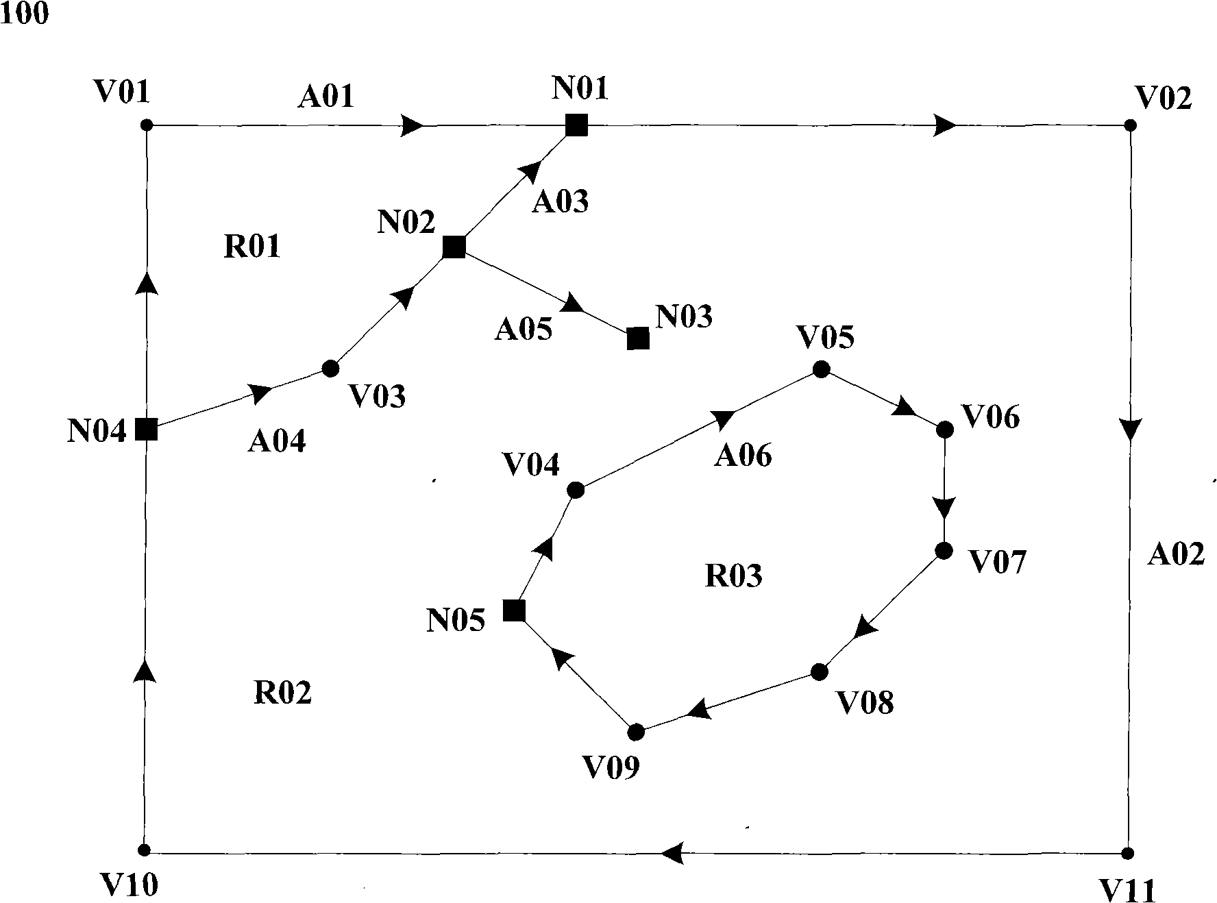
[0083] This preferred embodiment is implemented on a computer. The GIS topology data set needs to be created or loaded on the computer first and displayed on the display. The GIS topology data set is composed of zero or more topology objects. The object type includes three types: node, arc and area. A node is the point where the arc intersects or ends; the arc starts at the start node and ends at the end node. It is formed by connecting zero or more points. , These points connected into arcs are called nodes; an area is a closed range composed of an outer ring and zero or more inner rings, and a ring is formed by connecting one or more arcs.

[0084] figure 1 A graphic example 100 of a GIS topology data set according to an embodiment of the present invention is shown. The GIS topology data set includes 5 nodes, which are N01, N02, N03...


PUM


Abstract

Disclosed is a method for realizing the interactively editing of the GIS topological dataset; the method appends the topological object to the GIS topological dataset to create the topological dataset through the form that the coordinate points are inputted interactively to generate line segments; the method also modifies the topological dataset through moving the arc segments or nodes interactively and realizes the cancellation and recovery operations through adding the transaction mechanism; the cancellation and recovery operations are used for canceling the previous editing operation or recovering the previous cancelled editing operation when the editing result is inconsistent with the expectation or the editing result needs to be rolled back to the previous data state during the editing and processing process of the topological data so that the purposes of improving the safety, interactivity and the work efficiency in editing the GIS topological dataset are realized.

Description

Technical field [0001] The invention relates to GIS vector data editing technology, in particular to a method for interactively editing GIS topology data sets. Background technique [0002] Geographic Information System (GIS) vector data model includes two types, namely Spaghetti data model and topological data model (Chu Peng et al.: Introduction to Geographic Information System, Science Press, 2000, P31-43). In the Spaghetti model, a spatial point is represented by a spatial coordinate, a line is composed of a string of coordinates (called nodes), and a surface is a closed polygon formed by lines. The basic object types of the topology model include nodes, arcs and regions. The arcs are connected by a series of points (also known as nodes), which start from the starting node and end at the ending node; nodes are arcs intersecting or Terminating point; a region is a closed range composed of an outer ring and zero or more inner rings, and a ring is connected by one or more ...

Claims


Application Information

Patent Timeline
IPC IPC(8): G06F17/30
Inventor 邱永红
Owner 邱永红
Why Eureka
Try Eureka