On-board 3D terrain automatic measuring system and method

A three-dimensional terrain and automatic measurement technology, applied in the field of measurement, can solve the problems of high cost, low measurement efficiency, time-consuming and laborious, etc., and achieve the effect of reducing measurement cost and improving measurement efficiency

Inactive Publication Date: 2009-09-23
CHINA AGRI UNIV
View PDF1 Cites 13 Cited by
  • Summary
  • Abstract
  • Description
  • Claims
  • Application Information

AI Technical Summary

Problems solved by technology

[0005] However, when the above-mentioned prior art is measuring three-dimensional terrain, for each point to be measured, the measuring rod must be manually placed on the point to be measured, and the height of the measuring rod must be manually adjusted to reach the laser plane of the referenc

Method used


Image

  • On-board 3D terrain automatic measuring system and method
  • On-board 3D terrain automatic measuring system and method
  • On-board 3D terrain automatic measuring system and method

Examples


Embodiment Construction

[0023] The present invention will be described in further detail below in conjunction with the accompanying drawings and specific embodiments.

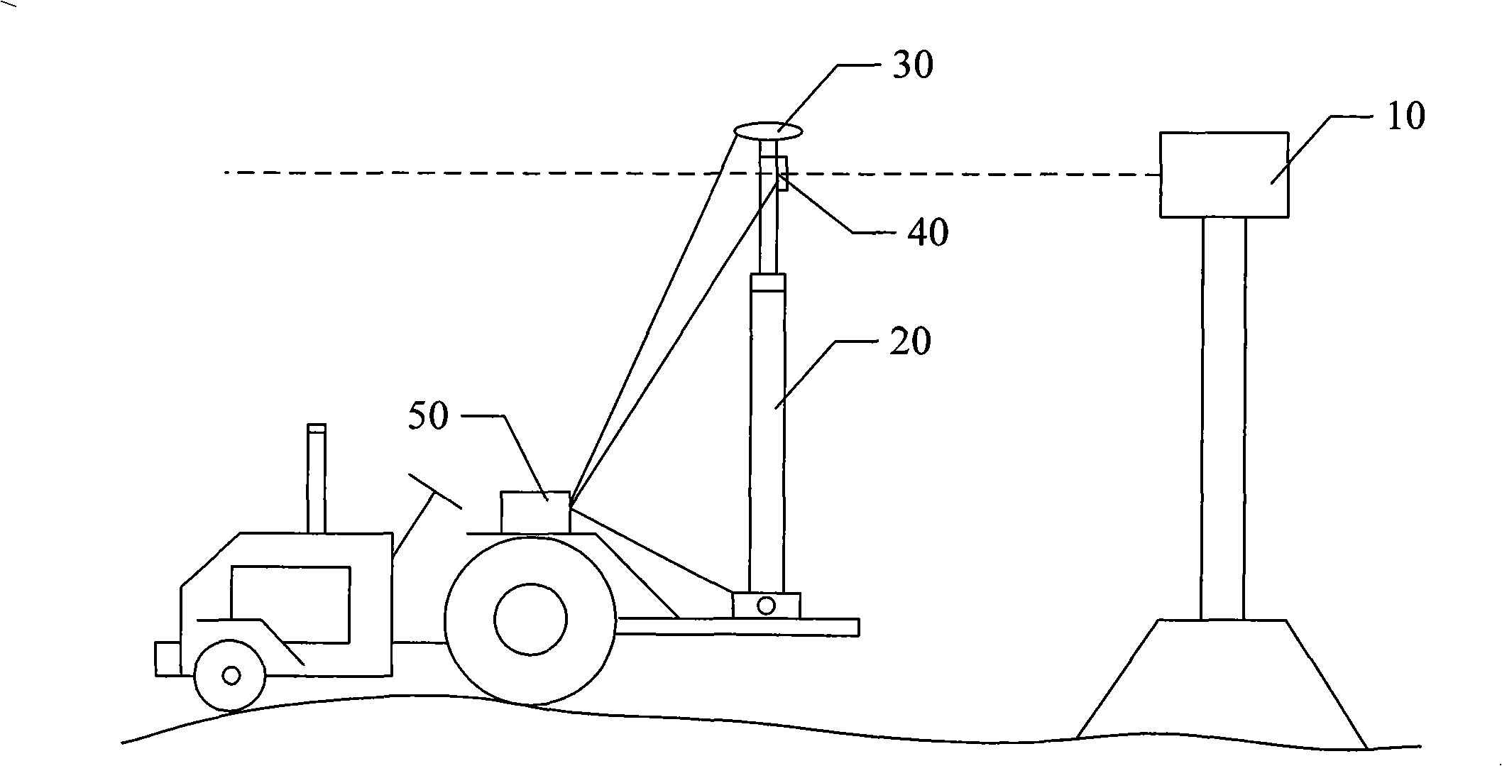
[0024] figure 1 It is a structural schematic diagram of the first embodiment of the airborne three-dimensional terrain automatic measurement system of the present invention. like figure 1 As shown, the embodiment of the airborne three-dimensional topographic automatic measurement system includes: a laser emitting device 10 , a measuring rod 20 , a GPS receiving device 30 , a laser measurement receiving device 40 and a controller 50 .

[0025] The laser emitting device 10 is arranged at an appropriate position on the ground to be measured through the supporting frame, and the supporting frame is adjusted so that the laser surface formed by the laser signal emitted by the laser emitting device 10 in rotation is higher than the top of the vehicle, that is, the laser surface is not blocked by the vehicle or other objects. block.
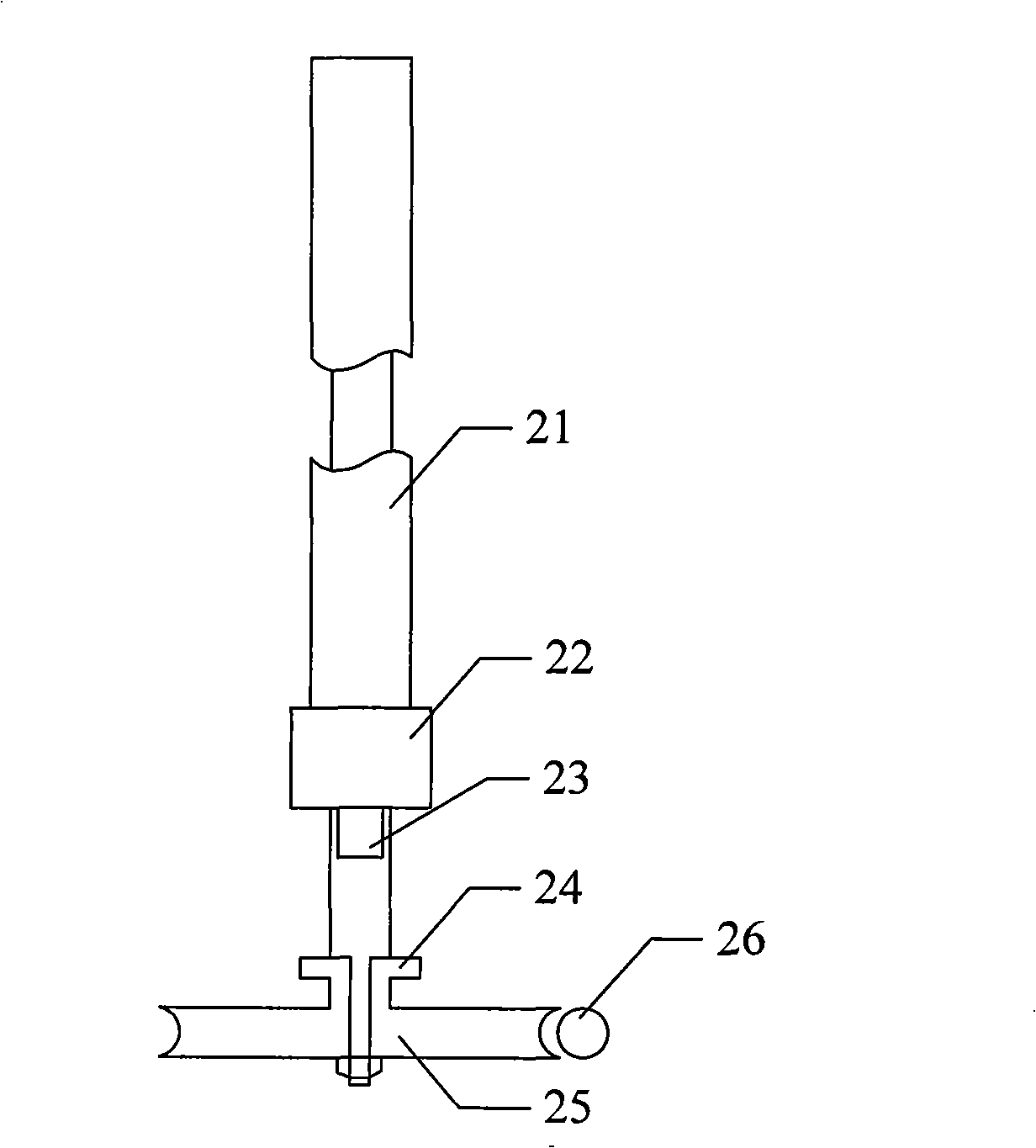
[002...


PUM


Abstract

The invention provides an on-board 3D terrain automatic measuring system and a method. The system comprises a laser transmitting device, a measuring rod, a GPS receiving device, a laser measuring receiving device and a controller; wherein, the laser measuring receiving device is arranged on the measuring rod and used for receiving a laser signal which is transmitted by the laser transmitting device. The measuring rod is arranged on a traveling vehicle; the laser measuring receiving device comprises a plurality of lengthways distributed silicon photocells and a plurality of measuring circuits, wherein, the measuring circuits are respectively connected with the silicon photocells; and the controller is respectively connected with the GPS receiving device and the laser measuring receiving device. The on-board 3D terrain automatic measuring system and the method thereof can automatically measure the 3D terrain in real time, generate the date of the 3D terrain, improve measuring efficiency and reduce measuring cost.

Description

technical field [0001] The invention relates to measurement technology, in particular to an airborne three-dimensional terrain automatic measurement system and method. Background technique [0002] Improving the leveling accuracy of the farmland ground can effectively improve the performance index of the ground irrigation system, and achieve a significant effect of saving water and increasing production. It is an important measure to improve the ground irrigation system by using laser-controlled leveling technology to achieve high-precision leveling of the farmland ground, thereby improving the terrain conditions of the farmland. In the leveling operation of the farmland ground, it is necessary to measure the three-dimensional topography before and after the leveling of the land in order to draw up a reasonable design scheme of the leveling project and quantitatively evaluate the leveling effect. [0003] Existing three-dimensional terrain surveying equipment mainly include...

Claims


Application Information

Patent Timeline
IPC IPC(8): G01B21/20G01C5/00G01S1/02
Inventor 刘刚郎晓哲谢幸福孟庆宽杨政
Owner CHINA AGRI UNIV
Why Eureka
Try Eureka