Intelligent output method for land parcel maps

An output method and technology of the map, applied in the directions of maps/plans/charts, instruments, educational appliances, etc., can solve the problems of manual judgment, lack of content screening, difficult to achieve, etc., to reduce workload, reduce map load, and reduce The effect of workload

Inactive Publication Date: 2009-12-02
ZHEJIANG UNIV
View PDF0 Cites 25 Cited by
  • Summary
  • Abstract
  • Description
  • Claims
  • Application Information

AI Technical Summary

Problems solved by technology

[0005] The deficiencies in the current parcel map mapping output process are as follows: (1) During the parcel map mapping output process, the paper size needs to be manually judged by the operator
(2) The content of the map lacks screening; it can be seen from the content of the map that in order to reduce the load on the map, it is not necessary to display its entire graphic or all boundary lines on the map of the neighboring block It is on...

Method used


Image

  • Intelligent output method for land parcel maps
  • Intelligent output method for land parcel maps
  • Intelligent output method for land parcel maps

Examples


Embodiment

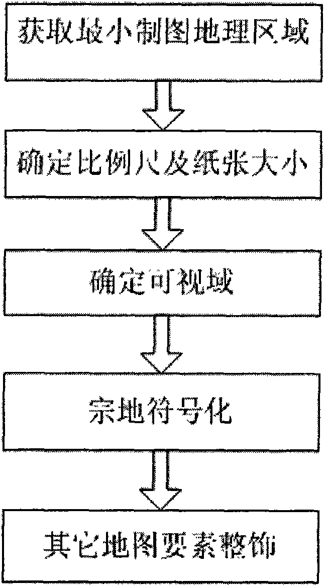
[0044] First, through the cadastral number or parcel number input by the user, the parcel graphic is obtained, and the size of its enclosing rectangle is calculated. And calculate the rectangle aspect ratio a:b. If a:b is greater than the paper aspect ratio (usually 16:9), increase the width of the rectangle so that its aspect ratio is the paper's aspect ratio, and if a:b is less than the paper's aspect ratio, increase the height of the rectangle , so that its aspect ratio is that of the paper. This determines the smallest cartographic geographic area bounded by the parcel's enclosing rectangle.

[0045] Then by interacting with the user, get the drawing scale or paper type. When the cartographic scale is determined, multiply the minimum cartographic geographic area range obtained in the previous step by the cartographic scale to calculate the minimum paper size and determine the required paper type. If the paper type is determined, the scale size can be obtained by dividin...


PUM

PropertyMeasurementUnit
Diameteraaaaaaaaaa

Abstract

The invention discloses an intelligent output method for land parcel maps based on GIS technology. The method can realize intelligent output printing of the land parcel maps adaptive to the national conditions of China by automatically extracting required information from a standard cadastre database. The method appoints a map scale or appoints the size of paper according to the user requirement to carry out map printing output; a user only needs to input an identification code of a land parcel such as a land parcel number or a cadastre number; and the method automatically acquires the land parcel maps, and determines the size and scale of the proper paper by calculating related map attributes. According to the land parcel maps, a map output mask is calculated so as to determine the visual range of the land parcel maps. The method also uses a label optimizing configuration algorithm so as to solve the gland problem of boundary point number labeling text elements. The method simulates the reasoning mode and thinking process during drawing, realizes intellectualization of land parcel map output, effectively reduces the workload during drawing the land parcel maps, and has large application prospect in the cadastral management field and other related drawing fields.

Description

technical field [0001] The invention relates to the field of cadastre management mapping, in particular to an intelligent output method of parcel maps based on GIS (Geographic Information System) technology. It also has a certain reference value for other related land industry mapping fields, and this method has practical significance for the office automation of the land department. Background technique [0002] The land parcel map is the attached map of the land certificate. After the approval of the land registration process with legal procedures, it is a legally effective map certificate held by the land owner or user, and it is a legally effective map when dealing with land ownership issues. pieces. [0003] The main contents of the parcel map include: map frame number, cadastral number; the parcel number, land category number, area and unit name; the boundary point and boundary point number of the parcel (including the boundary point shared with neighboring parcels) ...

Claims


Application Information

Patent Timeline
IPC IPC(8): G09B29/00
Inventor 张丰刘南刘仁义张亦萍杜震洪方雷
Owner ZHEJIANG UNIV
Why Eureka
Try Eureka