Multi-scale and multi-purpose land evaluation method and system

An evaluation method and multi-scale technology, applied in data processing applications, special data processing applications, instruments, etc., can solve the problems of repeated investigation and repeated calculation of data, so as to improve work efficiency, save investment, and promote land evaluation engineering. effect of development

Inactive Publication Date: 2010-01-20
WUHAN UNIV
View PDF0 Cites 12 Cited by
  • Summary
  • Abstract
  • Description
  • Claims
  • Application Information

AI Technical Summary

Problems solved by technology

Due to the basic data requirements of different evaluation types and different scales and levels of evaluation, there are a lot of overlaps and overlaps in the evaluation i

Method used


Image

  • Multi-scale and multi-purpose land evaluation method and system
  • Multi-scale and multi-purpose land evaluation method and system
  • Multi-scale and multi-purpose land evaluation method and system

Examples


Embodiment Construction

[0025] A multi-scale, multi-purpose approach to land evaluation includes the following steps:

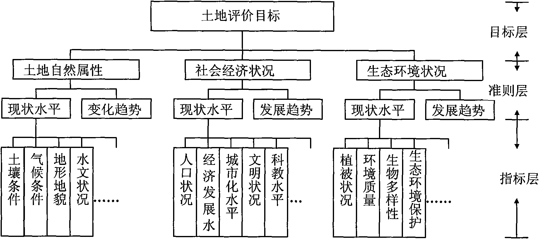
[0026] Based on different types of regions, different evaluation scales and evaluation types, the land evaluation index system is constructed, such as figure 1 shown;

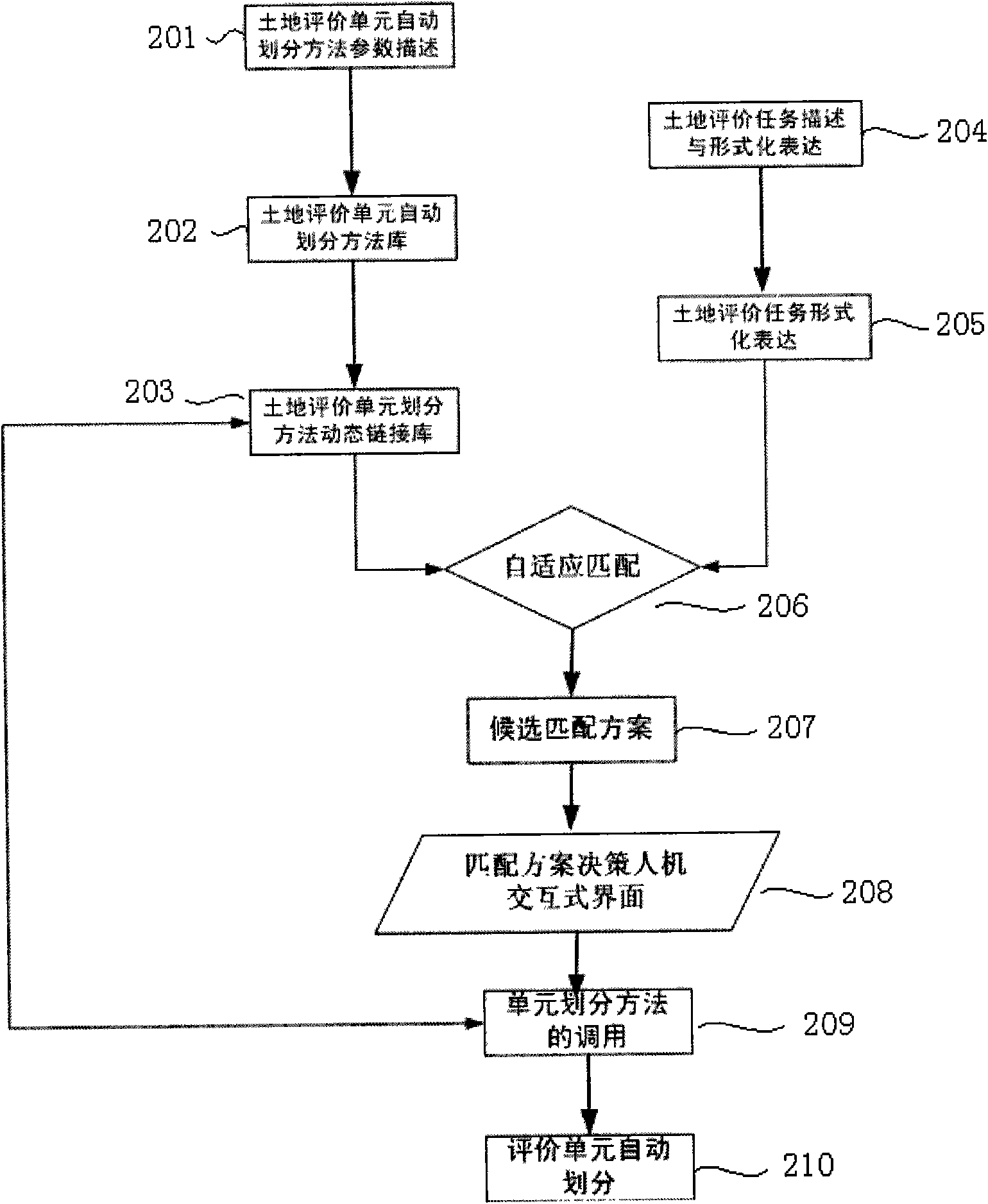
[0027] Select land evaluation units according to different regions, different scale requirements and different land evaluation types;

[0028] Calculate and evaluate the impact score of a single evaluation factor on the evaluation unit;

[0029] According to different evaluation application requirements, a quantitative model is selected to calculate the comprehensive influence of multiple factors, so as to realize the evaluation of land.

[0030] The land evaluation types mentioned above include land natural condition evaluation, economic evaluation and ecological evaluation. Among them, the natural conditions of the land include soil conditions, climate conditions, topography and hydrological conditions; the soci...


PUM


Abstract

The invention discloses a multi-scale and multi-purpose land evaluation method and a system integrating multiple types with multiple scales, wherein, the multiple types comprise land suitability evaluation, land potential evaluation, land economy evaluation, land ecology evaluation and the like, and the multiple scales comprise macro scale, midscopy scale, micro scale and the like; a land evaluation index system is built based on different types and areas, different evaluation scales and evaluation types. The invention comprises the following steps: selecting a land evaluation unit according to different areas, dimension requirements and land evaluation types; calculating and evaluating the impact effect marks of the single evaluation factor on the evaluation unit; selecting a quantified model according to different evaluation application requirements; calculating the comprehensive impact of multiple factors to realize the evaluation of land. The invention solves the problem of sharing and integration of land evaluation information, improves the work efficiency of land evaluation and promotes the land evaluation to develop toward the direction of quantification and automation.

Description

technical field [0001] The invention relates to a land evaluation method and system, in particular to the integration and system realization of land evaluation methods applied to multiple types of the same scale and different application purposes, and belongs to the field of land investigation and evaluation. Background technique [0002] The land evaluation information system is an inevitable requirement for the quantification and automation of land evaluation. The research and development of large-scale land evaluation information system has generally gone through three development stages. In the 1980s and 1990s, large-scale GIS software was used as an auxiliary tool for land evaluation spatial data management and spatial analysis to participate in land evaluation, such as the early Mapinfo, ArcGIS-based Such systems mainly use the GIS platform to solve the spatial data analysis and calculation problems in traditional land evaluation. There is no systematic land evaluation...

Claims


Application Information

Patent Timeline
IPC IPC(8): G06Q10/00G06Q50/00G06F19/00
Inventor 刘耀林刘艳芳
Owner WUHAN UNIV
Why Eureka
Try Eureka