Disturbing gravity-based quasi-geoid land-sea seamless splicing method

A technology of geoid and gravity disturbance, applied in the direction of artificial water level, height/horizontal measurement, measuring devices, etc., can solve problems such as lack of physical theory support, inconsistent datum, etc.

Inactive Publication Date: 2010-05-26
CHINESE ACAD OF SURVEYING & MAPPING
View PDF0 Cites 19 Cited by
  • Summary
  • Abstract
  • Description
  • Claims
  • Application Information

AI Technical Summary

Problems solved by technology

At the same time, the gravity anomaly is generally determined based on the local elevation datum, thus forming a "gravity anomaly" based on a variety of local elevation datums. Using this "gravity anomaly" to calculate the land-sea quasi-geoid is bound to have a problem of inconsistent datums
Simply using mathe

Method used


Image

  • Disturbing gravity-based quasi-geoid land-sea seamless splicing method
  • Disturbing gravity-based quasi-geoid land-sea seamless splicing method
  • Disturbing gravity-based quasi-geoid land-sea seamless splicing method

Examples


Embodiment Construction

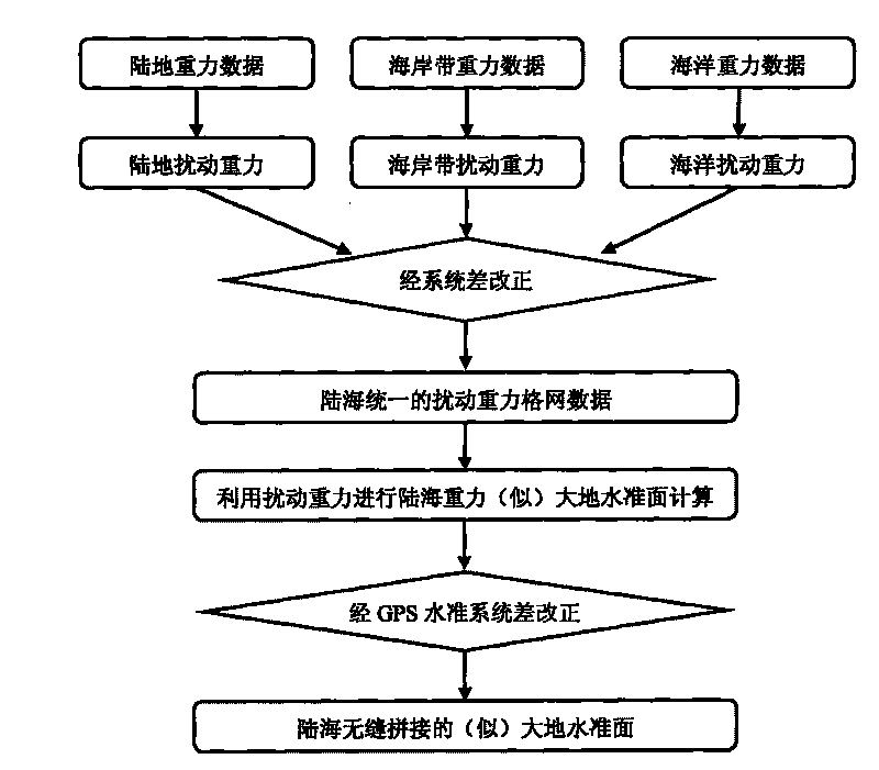
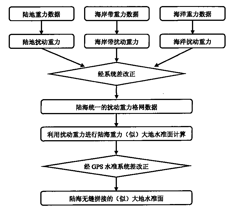
[0024] 1. Preprocessing of land and sea gravity data

[0025] The land and sea gravity data referred to in this paper mainly include land gravity data, coastline gravity data, and ocean gravity data. Theoretically speaking, if these three data are based on a unified frame (gravity reference frame, three-dimensional ellipsoid reference frame, etc.), then there is no systematic difference in these three data, that is, seamless splicing can be achieved completely. In fact, due to various factors such as the deviation of the gravity datum and the difference in the reference ellipsoid, there will be differences in splicing of the three different data, and there will be systematic deviations even in one type of data, for example, the early gravity data of my country and the 2000 gravity datum of China The maximum system deviation is more than ten milligal, and the gravity data in the ocean part is also very different due to different sources. Therefore, different gravity data need t...


PUM


Abstract

The invention discloses a disturbing gravity-based quasi-geoid land-sea seamless splicing method. In the method, the physical characteristic that the disturbing gravity is not limited by local height datum is fully utilized, a unified earth reference ellipsoid is taken as a coordinate reference frame, the land-sea unified disturbing gravity is calculated by adopting land-sea reference unified global navigation satellite system (GNSS) and gravity data, and the land-sea unified disturbing gravity is introduced to the more strict arithmetic provided by the invention so as to realize quasi-geoid land-sea seamless splicing. Different from the conventional fit algorithm for calculating land-sea height anomaly by utilizing gravity anomaly and a Stokes formula, the method is strict theoretically, and can eliminate result errors caused by the oddness of a kernel function.

Description

technical field [0001] The invention relates to a geoid-like sea-sea seamless splicing method based on disturbed gravity, and belongs to the technical field of "physical geodesy" in the discipline of "geodesy and surveying engineering". Background technique [0002] Land-sea quasi-geoid stitching is a hot and difficult point in the field of physical geodesy. At present, the main methods of land-sea quasi-geoid stitching include least squares spectrum combination method, iterative FFT method, least squares collocation method, etc. In recent years, an "extended method" has been developed in China, the basic principle of which is to calculate the quasi-geoid of the land, near the coastline, and the ocean through gravity anomalies, and then use the quasi-geoid near the coastline that coincides with the land to inversely calculate the fitting parameters , and finally use the obtained fitting parameters to correct the ocean quasi-geoid, so as to form a quasi-geoid seamlessly join...

Claims


Application Information

Patent Timeline
IPC IPC(8): G01C5/00G01C15/14
Inventor 张利明李斐章传银柯宝贵
Owner CHINESE ACAD OF SURVEYING & MAPPING
Why Eureka
Try Eureka