Multidimensional space information quality detecting and analyzing model and modeling method thereof

A multi-dimensional spatial information and analysis model technology, applied in the field of multi-dimensional spatial information quality detection and analysis models and its modeling, can solve the problems of lack of data quality detection and control process, poor accuracy and reliability of 3D geological models, etc., to achieve accuracy and reliability sex high effect

A multi-dimensional spatial information and analysis model technology, applied in the field of multi-dimensional spatial information quality detection and analysis models and its modeling, can solve the problems of lack of data quality detection and control process, poor accuracy and reliability of 3D geological models, etc., to achieve accuracy and reliability sex high effect

CN101853522AInactive Publication Date: 2010-10-06CHINA UNIV OF MINING & TECH (BEIJING)

Image

  • Multidimensional space information quality detecting and analyzing model and modeling method thereof
  • Multidimensional space information quality detecting and analyzing model and modeling method thereof
  • Multidimensional space information quality detecting and analyzing model and modeling method thereof

Examples


Embodiment Construction

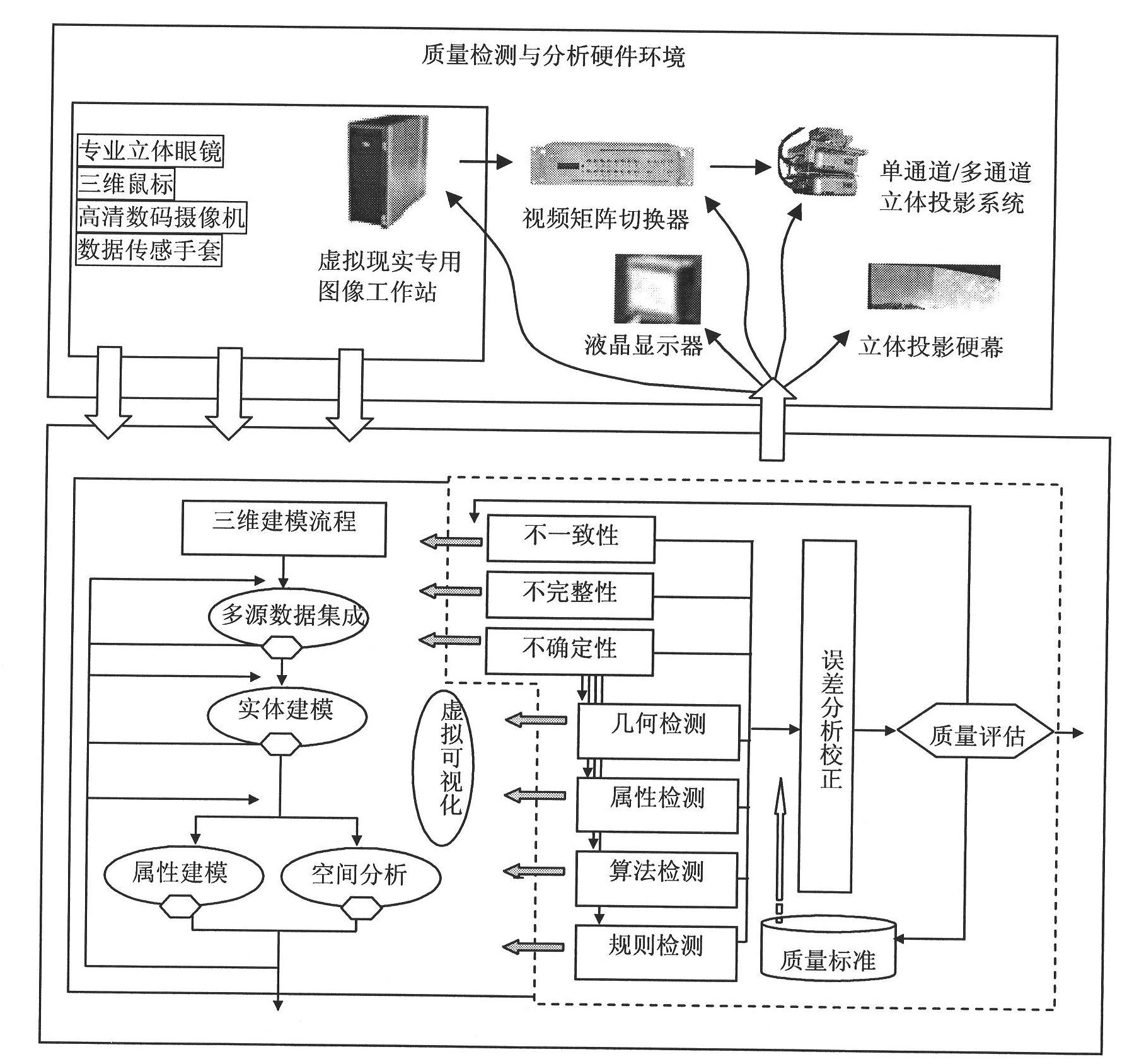
[0034] The preferred specific implementation of the multi-dimensional spatial information quality detection and analysis model of the present invention is as follows figure 1 Shown:

[0035] The multi-dimensional spatial information quality detection and analysis model includes:

[0036] Multi-source data analysis module: used to analyze the logical inconsistency of multi-source data integration in the process of 3D geological modeling and the incompleteness and uncertainty of data in the process of 3D geological modeling;

[0037] Error detection module: used for geometric detection, attribute detection, algorithm detection and rule detection in the process of 3D geological modeling;

[0038] Error analysis and correction module: used for error analysis and error correction in the process of 3D geological modeling;

[0039] Quality assessment module: used to assess the accuracy and reliability of 3D geological modeling;

[0040] Quality Standard Module: Establish general s...


PUM


Abstract

The invention discloses a multidimensional space information quality detecting and analyzing model and a modeling method thereof. The method comprises the following steps of: carrying out the processing of logic inconsistency analysis, data incompletion analysis, data uncertainty analysis, error detection, error analysis, error correction, and the like in the three-dimensional geological modeling process by a multisource data analyzing module, an error detecting module, an error analyzing and correcting module, a quality assessing module, a quality standard module, and the like; assessing whether the precision and the reliability of the established three-dimensional geological model meet the practical and applicable requirement or not by the quality assessing module; and further perfecting the quality standard module on the basis of the processing. The method can improve the precision and the reliability of the three-dimensional geological modeling.

Description

technical field [0001] The invention relates to a three-dimensional geological modeling and related technologies, in particular to a multi-dimensional spatial information quality detection and analysis model and a modeling method. Background technique [0002] Since the 1970s, the research on 3D geological modeling and related technologies has become a hot spot, and many research results have been achieved. , affects the accuracy of the 3D geological model, and its reliability is directly related to the analysis and application effect of spatial data. Some scholars have emphasized that the conclusions of spatial analysis that cannot be based on accurate data are incorrect, and spatial information systems that do not consider quality can produce various garbage at a relatively fast speed. Therefore, the detection and evaluation of spatial information quality in 3D geological modeling has become one of the most challenging topics in the world. [0003] In the prior art, some...

Claims


Application Information

Patent Timeline
06 Oct 2010
Publication
CN101853522A
IPC
G06T17/00
Inventors
武强; 徐华