Three-dimensional analog simulation system of instrument flight program

A flight procedure, three-dimensional technology, applied in the field of instrument flight procedure three-dimensional simulation system, can solve the problems of restricting the understanding of navigation standards, large manpower and material resources, and the increase of airport navigation facilities

Active Publication Date: 2011-02-09
沈阳广通测绘设计有限公司
View PDF3 Cites 10 Cited by
  • Summary
  • Abstract
  • Description
  • Claims
  • Application Information

AI Technical Summary

Problems solved by technology

Flight program design and airport management personnel usually use manual drawing method for analysis and calculation, and build a sand table model to display. Due to the complicated calculation and large measurement error, it is easy to make mistakes, and consumes a lot of manpower and material resources.
In addition

Method used


Image

  • Three-dimensional analog simulation system of instrument flight program
  • Three-dimensional analog simulation system of instrument flight program
  • Three-dimensional analog simulation system of instrument flight program

Examples


Embodiment 1

[0020] Example 1-Three-dimensional rendering of aeronautical chart elements:

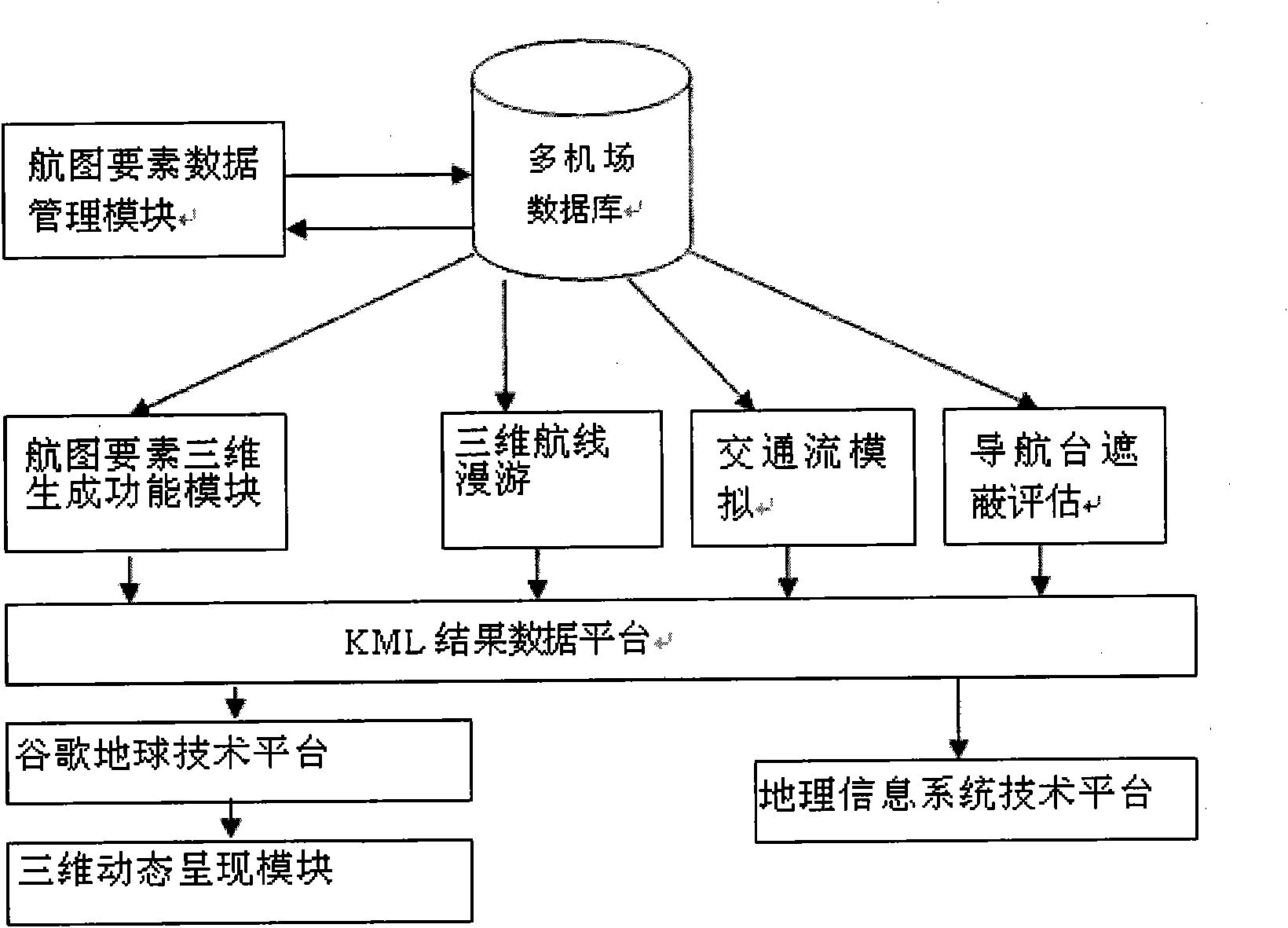
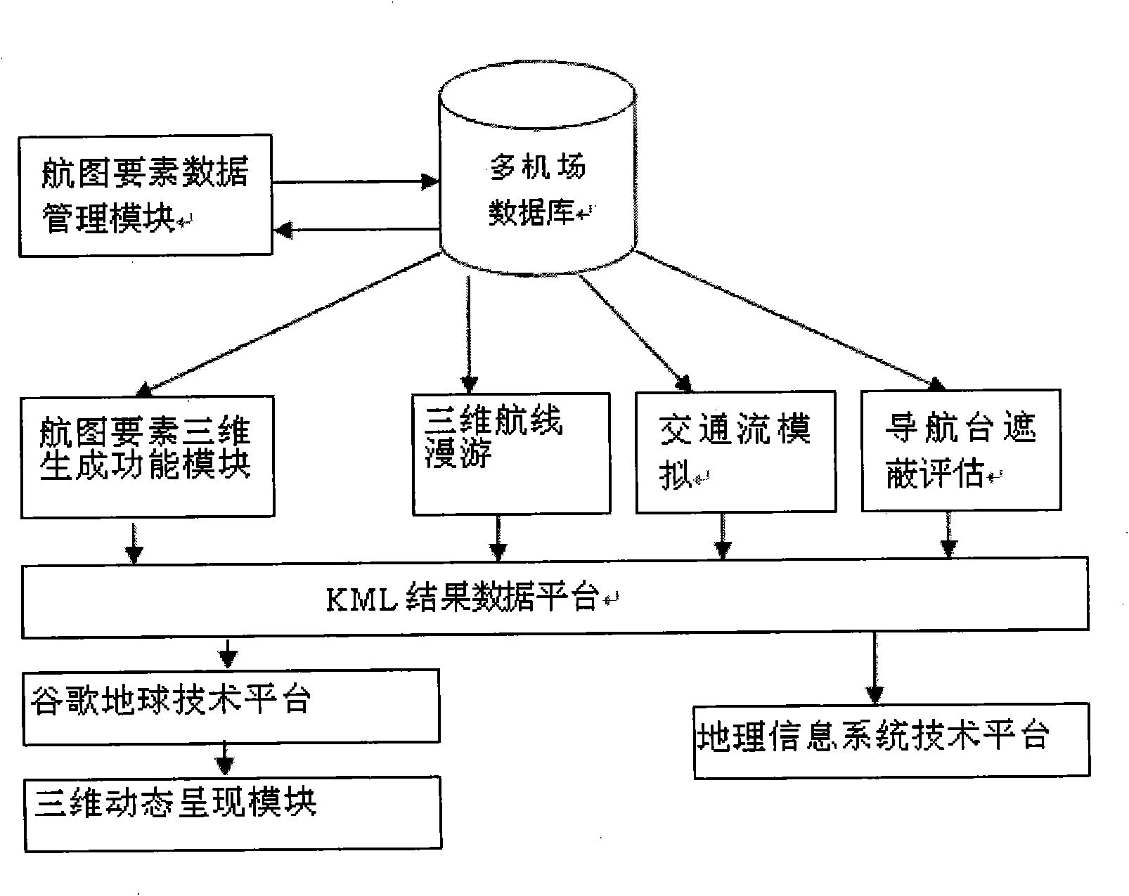
[0021] First establish the basic information of the airport, enter the airport code, the airport’s geographic coordinates, magnetic difference, elevation, runway length and width, magnetic direction, type of navigation station / positioning point, geographic coordinates, type of route, Height, approach and departure runway, node information, geographical coordinates of obstacles, height information, as well as the type of airspace, upper limit height and other information, these information is converted into the storage information in the database and stored in the multi-airport database through calculation The 6 functional modules in the element data management module classify and manage these data.

[0022] According to customer needs, the aeronautical chart element 3D generation function module retrieves one or more aeronautical chart elements from the multi-airport database, calculates the required dat...

Embodiment 2 3

[0024] Embodiment 2-Real-time multi-angle roaming of three-dimensional route:

[0025] First, establish the basic information of the airport as in the first embodiment, mainly to ensure the accuracy of the route type, altitude, approach and departure runway, node information, navigation station / positioning point type, and geographic coordinates.

[0026] According to the needs of customers, the route selection is performed. The 3D route roaming module uses the information to automatically generate a 3D route roaming algorithm, connects the route nodes, and simulates the roaming effect in 3D on the Google Earth technology platform. Realize the route roaming experience for controllers and pilots in the design of specific flight procedures, test the rationality of the airport flight procedure design, and observe the terrain and evaluate obstacles during route roaming. The system realizes real-time simulation of 3D roaming along the designated route and designated speed, and the displa...

Embodiment 3

[0027] Example three-real-time three-dimensional dynamic simulation of multi-airline traffic flow:

[0028] First, establish the basic information of the airport as in the first embodiment, mainly to ensure the accuracy of the route type, altitude, approach and departure runway, node information, type of navigation station / positioning point, and geographic coordinates.

[0029] According to customer needs, select any flight plan, the traffic flow simulation module will retrieve the corresponding multiple flight data from the database, calculate the location data of the flight through the traffic flow simulation algorithm, and send it to the KML result data platform , Generate the relevant kml file, dynamically load the generated kml file on the Google Earth technology platform, and realize the three-dimensional dynamic simulation of multi-route traffic flow through the three-dimensional dynamic rendering module.

[0030] The basic requirement of the traffic flow simulation system is ...


PUM


Abstract

The invention discloses a three-dimensional analog simulation system of an instrument flight program. The system comprises a multi-airport database, a chart element data management module, a chart element three-dimensional generation functional module, a three-dimensional flight course roaming module, a traffic flow analogue module, a navigation station shielding evaluation module, a keyhole markup language (KML) result data platform, a goggle geotechnical platform, a three-dimensional dynamic representation module and a geographic information system technical platform. The simulation system provides three-dimensional visualization technology for representing vision and instrument flight program design, so that 3D dynamic demonstration is formed by navigation elements designed by a two-dimensional diagram, works such as planning, demonstration, reporting and the like of related works such as airspace planning, vision, instrument flight program design, airport construction, navigation facility planning, site selection and the like are vivid and intuitive, the cost and the time cost of site exploitation, planning, airspace coordination, navigation facility shielding evaluation, airport clearance protection and evaluation and the like are reduced, and further the safety guard capacity of related works of civil aviation is improved.

Description

Technical field [0001] The invention relates to a three-dimensional simulation simulation system of an instrument flight program, which is used for visually displaying the design result of an airport flight program and evaluating its rationality in a 3D display environment, and belongs to the technical field of computer application. Background technique [0002] With the rapid development of my country's civil aviation industry, the number of aircraft is increasing, the scale of airport construction is increasing, and the construction speed of new airports is also accelerating. At this stage, the location of the airport, the erection of navigation stations, and the evaluation of obstacles , Still staying at the stage of "field survey, drawing on paper", even if the electronic map is used to display airports, navigation stations, and obstacles, it is limited to two-dimensional presentation, which is not only unintuitive, but also requires a lot of work. Flight program design and ai...

Claims


Application Information

Patent Timeline
IPC IPC(8): G06F17/50
Inventor 李斌郭兆宏田建华边境闫鹏
Owner 沈阳广通测绘设计有限公司
Why Eureka
Try Eureka